Palo Colorado Canyon, California
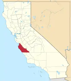
Palo Colorado Canyon is an unincorporated community in the Big Sur region of Monterey County, California.[1] The canyon entrance is located 11.3 miles (18.2 km) south of Carmel Valley River at the former settlement of Notley's Landing, 6.5 miles (10 km) north of Point Sur,[2] and at an elevation of 112 feet (34 m).[1]
Palo Colorado Canyon | |
|---|---|
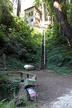 Home on Palo Colorado Road | |
 Palo Colorado Canyon Location in California  Palo Colorado Canyon Palo Colorado Canyon (the United States) | |
| Coordinates: 36°23′58″N 121°53′17.5″W | |
| Country | United States |
| State | California |
| County | Monterey County |
| Elevation | 112 ft (34 m) |
Etymology
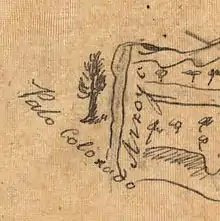
Arroyo de Palo Colorado was first named on a diseño, a hand-drawn descriptive map of Rancho San Jose y Sur Chiquito, that was submitted by Jose Castro to the Land Claims Commission in 1853 to prove his title to the rancho.[3][4]
Road
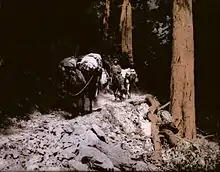
The entrance to the road is at the former settlement at Notley's Landing. The first 3 miles (4.8 km) of road winds through a Redwood tree-lined canyon alongside Palo Colorado Creek. It then climbs sharply up a stretch of road to a point known locally as The Hoist and into the Rocky Creek watershed. The name for "The Hoist" came about because of the very steep road which during the turn of the century required wagon-loads of tanbark and lumber to be hoisted by block and tackle hitched to oxen.[5] The old block and tackle is still chained to a massive log beam, now used to support mailboxes and labeled "The Hoist."[6] The road ended at this point until 1950, when the US Army Corps of Engineers began a construction project to extend the road to the North fork of the Little Sur River and future site of Camp Pico Blanco.
The road connects to two private unpaved roads to the north. Garrapata Road connects into Garrapata State Park and the other, over Long Ridge, connects to the Big Sur Land Trust's Glen Deven Ranch. Both are only used as fire emergency routes.[7]
The road ends after 7.4 miles (11.9 km) at Bottchers Gap, at 2,050 feet (620 m) altitude, the site of former homesteader John Bottcher's cabin in 1885–90. It is currently a primitive campsite and trail head into the Ventana Wilderness and the Los Padres National Forest. A locked gate provides access to a 3.3 miles (5.3 km) long private road leading to Camp Pico Blanco.[8][9]
Closures
The last five-mile segment of Palo Colorado Road was heavily damaged in January 2017. Heavy rains caused debris to block a culvert under the road and Rocky Creek overflowed Palo Colorado Road at mile marker 3.3.[10] The floods resulted from runoff from lands burnt by the Soberanes Fire. Monterey County installed a temporary bridge at Rocky Creek.[11][12]
The county repaired the road where it crosses Rocky Creek in 2018, but slipouts farther east on the road remain and the road as of June 2020 remains closed.[13][14][15] The rains caused considerable additional damage to the road between The Hoist at milepost 4.0 and Bottcher's Gap at milepost 7.4. In August, 2018, the county installed a security gate at The Hoist to prevent non-residents from proceeding further. Camp Pico Blanco, Mill Creek Redwood Preserve, and the Bottchers Gap campground and trail head are closed. About 60 homes are in the area beyond the closure. The county estimates the four projects in that area will cost about $11 million.[16]
The county does not have sufficient funds to repair the entire road and is applying for federal grants. The cost for all of all repairs along the road from milepost 1.0 to 7.4 at Bottcher's Gap is about $20 million.[16]
History
Esselen home
Before the arrival of Europeans, the land was occupied by the Esselen people. They had a number of seasonal villages located along the Big Sur coast from near present-day Hurricane Point to the vicinity of Vicente Creek in the south, inland to the upper Carmel and Arroyo Seco Rivers. A large boulder with a dozen or more deep mortar bowls worn into it, known as a bedrock mortar, is located in Apple Tree Camp on the southwest slope of Devil's Peak, northeast of Palo Colorado Road.[17]
Adler Ranch
Yankee businessman Charles Henry Bixby obtained a patent on April 10, 1889 for 160 acres (65 ha) south of Bixby Creek,[18] and later bought additional tracts of land on the north side of the creek, between it and Palo Colorado Canyon. In the 20th century, Axel Adler built a cabin on the former Bixby Ranch and gradually acquired more land. In 2013, descendants of the Adler family who lived in Sweden put 1,312 acres (531 ha) of the Adler Ranch on the market for $15 million. It is located at the end and south of Palo Colorado Road. The ranch is located along the Little Sur River at the northwestern edge of the Ventana Wilderness adjacent to the Monterey Peninsula Regional Park District's Mill Creek Redwood Preserve, Los Padres National Forest, and includes the peak of Bixby Mountain and the upper portions of Mescal Ridge. The El Sur Ranch and Pico Blanco Mountain are to the south.[19][20][21]
The nonprofit Western Rivers Conservancy secured a purchase agreement for the land. It initially wanted to sell the land to the US Forest Service, which would make it possible for hikers to travel from Bottchers Gap to the sea. But some local residents thought the federal agency lacked funding required to maintain a critical fire break on the land.[19][20]
On October 2, 2019, the California Natural Resources Agency announced it was seeking funding to obtain the land for the Esselen tribe. The Adler family agreed to sell 1,199 acres (485 ha) of the Adler Ranch.[21] In late July 2020 the purchase of the Adler Ranch successfully closed and the property was transferred to the Esselen tribe.[22] The land acquisition could help facilitate federal recognition of the tribe.[21][22]
Mission era
During the Spanish mission era from 1769 to 1833, the native people were heavily affected by the establishment of three missions (Mission San Carlos Borromeo de Carmelo, Mission Nuestra Señora de la Soledad, and Mission San Antonio de Padua) near them from 1770 to 1791.[17] The native population was decimated by disease, including measles, smallpox, and syphilis, which wiped out 90 percent of the native population,[23]: and by conscript labor, poor food, and forced assimilation. Virtually all of the Esselen people's villages within the current Los Padres National Forest were left largely uninhabited.[24]
Rancho era
Rancho San Jose y Sur Chiquito was first granted in 1835 to Teodoro Gonzalez and re-granted by Governor Juan Alvarado the same year to Marcelino Escobar. It bordered the first mile of Palo Colorado Canyon to the north. It was later owned by Jose Castro and was used for farming and ranching.[25][26]
Homesteaders
Early homesteaders in the Palo Colorado Canyon region included Samuel L. Trotter (January 23, 1914),[27] George Notley (March 21, 1896),[28] and his brother William F. Notley (May 8, 1901),[29] and Andre Cushing who bought a 40-acre patent just east of the mouth of the canyon.[30] After filing a patent for a homestead, the settler had complete ownership after residing on the property for five years or after six months with payment of $1.50 per acre.[31]
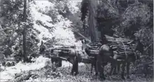
Notley began harvesting tanoak bark from the canyon, a lucrative source of income at the time. The bark was used to manufacture tannic acid, necessary to the growing leather tanning industry located in Santa Cruz, about 40 miles to the north. Notley constructed a landing at the mouth of the Palo Colorado River like that at Bixby Landing to the south. The tanbark was harvested from the isolated trees inland, corded, brought out by mule back or using wooden sleds, and loaded by cable onto waiting vessels anchored offshore at Notley's Landing.
Swetnam and Trotter worked for the Notley brothers, who harvested Redwood in the Santa Cruz area and expanded operations to include tanbark in the mountains around Palo Colorado Canyon. Swetnam married Adelaide Pfeiffer and bought the Notley home at the mouth of Palo Colorado Canyon for their residence. He also constructed two cabins and a small barn on his patent along the Little Sur River at the site of the future Pico Blanco camp.
Road construction and logging left many steep canyons denuded. The resulting erosion clogged stream with sediment and woody debris for decades after loggers cleared the land and moved their timber to mills and coastal landings.[32]
Mill Creek Redwood Preserve
A portion of land to the south of Palo Colorado Canyon formerly owned by Charles Henry Bixby was sold to a lumber company in 1986. Their plan to harvest over a million board feet of redwood was only derailed by the savings and loan crisis, when the land was seized by federal financial regulators. They sold the property to the Big Sur Land Trust, which in turn sold it to the Monterey Peninsula Regional Park District in 1988. The district joined it with three adjacent properties to form the Mill Creek Redwood Preserve.[33] The county hired a crew to build a 2.7 miles (4.3 km) trail from Palo Colorado Road to an overlook, which was completed over ten years. Responding to concerns of canyon residents about traffic on narrow Palo Colorado Road, the county agreed to limit access to six permits per day. Visitors are required to obtain a permit in advance from the Monterey Peninsula Regional Park District. The trail head is located 6 miles (9.7 km) inland on Palo Colorado Road.[33][34]
Palo Colorado Association
The Palo Colorado Association was formed in 1917 and legally organized in 1928. Its purposes are to provide social and recreational opportunities to its members, manage real and personal property belonging to members, provide upkeep of the association property, and to hire a caretaker to manage their properties. It includes the owners of eleven cabins that are more than 100 years old. The cabins are built of whole logs alongside Palo Colorado Creek and within the first three-tenths of a mile near the entrance to the canyon.[35][36]
Fire impact
Historical fires
In 1906, a fire that began in Palo Colorado Canyon from the embers of a campfire burned for 35 days, scorching an estimated 150,000 acres (61,000 ha), and was finally extinguished by the first rainfall of the season.[37]
On August 26, 1924, a fire started in Danish Creek in the Carmel River watershed. It burned 49,400 acres (20,000 ha) until it was extinguished by rainfall on October 4. This was the largest fire for more than 50 years, until the Marble Cone Fire in 1977.[38]
In October, 2007, a fire broke out in a residence in the canyon and spread to nearby brush. About 50 acres (20 ha) were burned. While fighting the fire, Matthew Will, a bulldozer operator with CalFire, was killed when his bulldozer rolled down a steep slope.[39]
2016 Soberanes fire
The July 2016 Soberanes Fire was caused by unknown individuals who started and lost control of an illegal campfire in the Garrapata Creek watershed. During the first few days of the fire, it destroyed 57 homes and 11 outbuildings in the Garrapata and Palo Colorado Canyon areas. Fire fighters were able to build lines around parts of the Big Sur community. A bulldozer operator was killed when his equipment overturned during night operations in Palo Colorado Canyon.[40][41][42][43]
Population
The United States does not define a census-designated place called Palo Colorado Canyon, but it does define a ZIP Code Tabulation Area (ZCTA), 93923 which extends north to include parts of Carmel Valley and Carmel-by-the-Sea, so it is not possible to obtain census data for the canyon itself.[44]
As of 2004, there were about 300 households in the Palo Colorado Canyon area. The residents raised $300,000 to build a firehouse to house the Mid-Coast Fire Brigade, an all-volunteer unit that offers fire protection to the area.[45]
Government
At the county level, Palo Colorado Canyon is represented on the Monterey County Board of Supervisors by Supervisor Dave Potter.[46]
In the California State Legislature, Palo Colorado Canyon is in the 17th Senate District, represented by Democrat John Laird, and in the 30th Assembly District, represented by Democrat Robert Rivas.[47]
In the United States House of Representatives, Palo Colorado Canyon is in California's 20th congressional district, represented by Democrat Jimmy Panetta[48]
References
- U.S. Geological Survey Geographic Names Information System: Palo Colorado Canyon, California
- Durham, David L. (1998). California's Geographic Names: A Gazetteer of Historic and Modern Names of the State. Clovis, Calif.: Word Dancer Press. p. 930. ISBN 1-884995-14-4.
- Grimes, Teresa; Heumann, Leslie (January 7, 1997). "Historic Context Statement Carmel-by-the-Sea". ci.carmel.ca.us. Archived from the original on 2015-09-21. Retrieved 30 December 2017.
- Gustav, Erwin (1998). California Place Names: The Origin and Etymology of Current Geographical Names 1889-1969. Bright, William (fourth, rev. and enl. ed.). Berkeley: University of California Press. p. 279. ISBN 9780520266193. OCLC 37854320.
- "Mill Creek Redwood Preserve". Monterey Peninsula Regional Park District. 2009. Archived from the original on February 10, 2007. Retrieved October 27, 2009.
- Fischer, Meade. "Five Great Winter Hikes in Big Sur". Archived from the original on July 10, 2012. Retrieved November 14, 2009.
- Trust, Big Sur Land. "Landscapes - Glen Deven Ranch (Big Sur Land Trust)". Archived from the original on 2018-01-01.
- Wood, Lea (Fall 2001). "The Story of Comings Cabin". Double Cone Quarterly, Volume IV, Number 3. Archived from the original on January 24, 2010. Retrieved November 15, 2009.
- "John Bottcher, Patent #CACAAA-090676". The Land Patent. September 25, 1888. Retrieved 12 August 2016.
- Coury, Nic. "County explores taking over Palo Colorado Road from the feds, braces for $13.5 million in repairs". Archived from the original on 2017-07-20. Retrieved 2018-01-01.
- "California's Big Sur Coast: A Scenic Drive - Foster Travel Publishing". 19 July 2012. Archived from the original on 1 January 2018.
- Wright, Tom. "Palo Colorado Road to close for months as crews repair culverts". Monterey Herald. Archived from the original on 3 May 2018. Retrieved 3 May 2018.
- "Palo Colorado Road Repair Projects". Archived from the original on 2018-01-08. Retrieved 2018-01-07.
- "Monterey County closes part of Palo Colorado Road due to storm damage". Archived from the original on 2018-01-08. Retrieved 2018-01-07.
- "Palo Colorado Road Repair Project - Harris & Associates". Harris & Associates. Archived from the original on 2018-01-08. Retrieved 2018-01-07.
- "Palo Colorado's long road to repair". Archived from the original on 2019-11-11. Retrieved 2020-05-30.
- Breschini, Gary S.; Trudy Haversat. "A Brief Overview of the Esselen Indians of Monterey County". Montery County Historical Society. Archived from the original on November 22, 2011. Retrieved November 3, 2011.
- "Charles H Bixby, Patent #CACAAA-090682". The Land Patents. Retrieved 20 August 2016.
- Counts, Chris (March 26, 2010). "Big Sur mountain is on the market: $15M". www.pineconearchive.com.
- Schmalz, David. "A proposition to create more public land in Big Sur has some residents seeing red". Monterey County Weekly. Retrieved 19 March 2018.
- Shalev, Asaf. "The Esselen of Big Sur are landless no more, thanks to a $4.5 million state grant". Monterey County Weekly. Retrieved 4 June 2020.
- Rogers, Paul (2020-07-27). "Big Sur tribe regains land 250 years after being removed". The Mercury News. Retrieved 2020-07-28.
- Kripal, Jeffrey J. (April 2007). America and the Religion of No Religion. Chicago: The University of Chicago Press. p. 594. ISBN 9780226453712.
- Blakley, E.R. "Jim"; Barnette, Karen (July 1985). "Historical Overview of the Los Padres National Forest" (PDF). ForestWatch. Archived (PDF) from the original on February 7, 2016.
- Grimes, Teresa; Heumann, Leslie (January 7, 1997). "Historic Context Statement Carmel-by-the-Sea". ci.carmel.ca.us. Archived from the original on 10 May 2014. Retrieved 30 December 2017.
- Ogden Hoffman, 1862, Reports of Land Cases Determined in the United States District Court for the Northern District of California, Numa Hubert, San Francisco
- "Samuel M Trotter, Patent #CASF--0005429". The Land Patents. Retrieved 28 July 2016.
- "George A Notley, Patent #CACAAA-090763". The Land Patents. Retrieved 28 July 2016.
- "William F Notley, Patent #CACAAA-092695". The Land Patents. Retrieved 28 July 2016.
- "William F Notley, Patent #CACAAA-092695". The Land Patents. Retrieved 28 September 2017.
- Blakley, E.R. “Jim” and Karen Barnette Historical Overview of the Los Padres National Forest July 1985
- Nedeff, Nicole (December 1, 2004). "Garrapata Creek Watershed Assessment and Restoration Plan Riparian Element" (PDF). Archived (PDF) from the original on 23 May 2016. Retrieved 14 August 2016.
- "Mill Creek Redwood Preserve". Monterey Peninsula Regional Park District. Archived from the original on September 19, 2016. Retrieved September 5, 2016.
 This article incorporates text from this source, which is in the public domain.
 - Anderson, Corby. "Mill Creek Redwood Preserve Trail taps the serenity of Palo Colorado Canyon". Monterey County Weekly. Archived from the original on October 30, 2018. Retrieved August 12, 2016.
- Sernoffsky, Evan (January 8, 2017). "Weekend storm batters resilient, remote Big Sur communities". San Francisco Chronicle. Archived from the original on January 8, 2018. Retrieved 2018-01-08.
- "Articles of Incorporation Palo Colorado Association", California Secretary of State, November 29, 2007
- Rogers, David. "The Big Sur Fire of 1906". Double Cone Quarterly. Archived from the original on 28 June 2016. Retrieved 22 August 2016.
- "Mid-Coast Fire Brigade". www.midcoastfirebrigade.org. Archived from the original on 2018-01-01. Retrieved 2018-01-01.
- Congressional Record Proceeding and Debates of the 110th Congress First Session Volume 153-Part 20. Government Printing Office.
- Murphy, Mike (August 1, 2016). "Wildfire cripples tourism in California's scenic Big Sur". MarketWatch. Archived from the original on August 29, 2016. Retrieved August 22, 2016.
- "Soberanes Fire: A survivor's story in Palo Colorado". Archived from the original on 2018-01-01.
- "Homes in Palo Colorado Canyon destroyed by wildfire". KWBW. Archived from the original on September 5, 2016. Retrieved September 6, 2015.
- Handy, Ryan Maye; Gabbert, Bill. "Damage assessment teams document 57 homes destroyed in Soberanes Fire". WildFireToday.com. Archived from the original on 17 September 2016. Retrieved 7 September 2016.
- "Carmel-by-the-Sea city, California". American Fact Finder. U.S. Census Bureau. Retrieved 7 September 2016.
- Howe, Kevin. "Palo Colorado Canyon, California Station To Go Up". Firehouse.com. Archived from the original on 12 October 2016. Retrieved 7 September 2016.
- "Monterey County Supervisorial District 5 Map (North District 5)" (PDF). County of Monterey. Archived from the original (PDF) on 1 July 2012. Retrieved 21 September 2012.
- "Statewide Database". UC Regents. Archived from the original on February 1, 2015. Retrieved February 11, 2015.
- "California's 20th Congressional District - Representatives & District Map". Civic Impulse, LLC. Retrieved September 24, 2014.
This article contains content from government publications that are in the public domain.

