Saint-Nizier-de-Fornas
Saint-Nizier-de-Fornas is a commune in the Loire department in central France.
Saint-Nizier-de-Fornas | |
|---|---|
Commune | |
 | |
.svg.png.webp) Coat of arms | |
Location of Saint-Nizier-de-Fornas 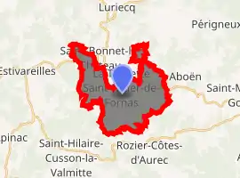
| |
 Saint-Nizier-de-Fornas  Saint-Nizier-de-Fornas | |
| Coordinates: 45°24′16″N 4°04′57″E | |
| Country | France |
| Region | Auvergne-Rhône-Alpes |
| Department | Loire |
| Arrondissement | Montbrison |
| Canton | Saint-Just-Saint-Rambert |
| Intercommunality | Saint-Étienne Métropole |
| Government | |
| • Mayor (2014–2020) | Gilbert Soulier |
| Area 1 | 15.88 km2 (6.13 sq mi) |
| Population (2017-01-01)[1] | 666 |
| • Density | 42/km2 (110/sq mi) |
| Time zone | UTC+01:00 (CET) |
| • Summer (DST) | UTC+02:00 (CEST) |
| INSEE/Postal code | 42266 /42380 |
| Elevation | 619–995 m (2,031–3,264 ft) (avg. 792 m or 2,598 ft) |
| 1 French Land Register data, which excludes lakes, ponds, glaciers > 1 km2 (0.386 sq mi or 247 acres) and river estuaries. | |
Population
| Year | Pop. | ±% |
|---|---|---|
| 1793 | 1,100 | — |
| 1806 | 1,164 | +5.8% |
| 1821 | 1,114 | −4.3% |
| 1831 | 1,167 | +4.8% |
| 1841 | 1,276 | +9.3% |
| 1851 | 1,223 | −4.2% |
| 1861 | 1,115 | −8.8% |
| 1872 | 1,028 | −7.8% |
| 1881 | 1,022 | −0.6% |
| 1891 | 984 | −3.7% |
| 1901 | 989 | +0.5% |
| 1911 | 909 | −8.1% |
| 1921 | 868 | −4.5% |
| 1931 | 778 | −10.4% |
| 1946 | 604 | −22.4% |
| 1954 | 586 | −3.0% |
| 1962 | 501 | −14.5% |
| 1968 | 452 | −9.8% |
| 1975 | 436 | −3.5% |
| 1982 | 453 | +3.9% |
| 1990 | 585 | +29.1% |
| 1999 | 585 | +0.0% |
| 2009 | 639 | +9.2% |
| 2017 | 666 | +4.2% |
See also
References
- "Populations légales 2017". INSEE. Retrieved 6 January 2020.
| Wikimedia Commons has media related to Saint-Nizier-de-Fornas. |
| Authority control |
|---|
This article is issued from Wikipedia. The text is licensed under Creative Commons - Attribution - Sharealike. Additional terms may apply for the media files.