Sainte-Agathe-la-Bouteresse
Sainte-Agathe-la-Bouteresse is a commune in the Loire department in central France.
Sainte-Agathe-la-Bouteresse | |
|---|---|
Commune | |
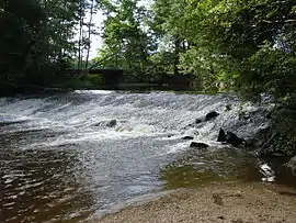 A weir on the Lignon du Forez | |
.svg.png.webp) Coat of arms | |
Location of Sainte-Agathe-la-Bouteresse 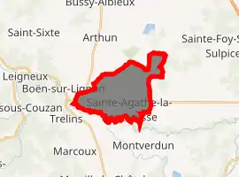
| |
 Sainte-Agathe-la-Bouteresse  Sainte-Agathe-la-Bouteresse | |
| Coordinates: 45°44′06″N 4°03′21″E | |
| Country | France |
| Region | Auvergne-Rhône-Alpes |
| Department | Loire |
| Arrondissement | Montbrison |
| Canton | Boën-sur-Lignon |
| Intercommunality | CA Loire Forez |
| Government | |
| • Mayor (2014–2020) | Pierre Dreyet |
| Area 1 | 11.75 km2 (4.54 sq mi) |
| Population (2017-01-01)[1] | 1,023 |
| • Density | 87/km2 (230/sq mi) |
| Time zone | UTC+01:00 (CET) |
| • Summer (DST) | UTC+02:00 (CEST) |
| INSEE/Postal code | 42197 /42130 |
| Elevation | 355–411 m (1,165–1,348 ft) (avg. 387 m or 1,270 ft) |
| 1 French Land Register data, which excludes lakes, ponds, glaciers > 1 km2 (0.386 sq mi or 247 acres) and river estuaries. | |
Geography
The river Lignon du Forez flows through the commune.
Population
| Year | Pop. | ±% |
|---|---|---|
| 1793 | 365 | — |
| 1806 | 148 | −59.5% |
| 1821 | 226 | +52.7% |
| 1831 | 319 | +41.2% |
| 1841 | 343 | +7.5% |
| 1851 | 445 | +29.7% |
| 1861 | 425 | −4.5% |
| 1872 | 468 | +10.1% |
| 1881 | 534 | +14.1% |
| 1891 | 563 | +5.4% |
| 1901 | 573 | +1.8% |
| 1911 | 545 | −4.9% |
| 1921 | 514 | −5.7% |
| 1931 | 529 | +2.9% |
| 1946 | 574 | +8.5% |
| 1954 | 604 | +5.2% |
| 1962 | 656 | +8.6% |
| 1968 | 757 | +15.4% |
| 1975 | 791 | +4.5% |
| 1982 | 831 | +5.1% |
| 1990 | 846 | +1.8% |
| 1999 | 813 | −3.9% |
| 2009 | 1,062 | +30.6% |
| 2016 | 1,012 | −4.7% |
See also
References
- "Populations légales 2017". INSEE. Retrieved 6 January 2020.
| Wikimedia Commons has media related to Sainte-Agathe-la-Bouteresse. |
| Authority control |
|---|
This article is issued from Wikipedia. The text is licensed under Creative Commons - Attribution - Sharealike. Additional terms may apply for the media files.