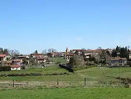
Saint-Georges-Lagricol
Saint-Georges-Lagricol is a commune in the Haute-Loire department in south-central France.
Saint-Georges-Lagricol | |
|---|---|
Commune | |
 | |
Location of Saint-Georges-Lagricol 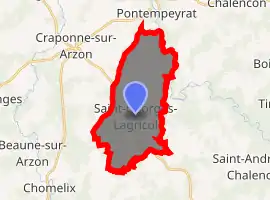
| |
 Saint-Georges-Lagricol  Saint-Georges-Lagricol | |
| Coordinates: 45°17′56″N 3°53′13″E | |
| Country | France |
| Region | Auvergne-Rhône-Alpes |
| Department | Haute-Loire |
| Arrondissement | Le Puy-en-Velay |
| Canton | Plateau du Haut-Velay granitique |
| Government | |
| • Mayor (2014–2020) | André Roche |
| Area 1 | 19.17 km2 (7.40 sq mi) |
| Population | 527 |
| • Density | 27/km2 (71/sq mi) |
| Time zone | UTC+01:00 (CET) |
| • Summer (DST) | UTC+02:00 (CEST) |
| INSEE/Postal code | 43189 /43500 |
| Elevation | 743–963 m (2,438–3,159 ft) (avg. 850 m or 2,790 ft) |
| 1 French Land Register data, which excludes lakes, ponds, glaciers > 1 km2 (0.386 sq mi or 247 acres) and river estuaries. | |
Population
| Year | Pop. | ±% |
|---|---|---|
| 1793 | 1,076 | — |
| 1806 | 905 | −15.9% |
| 1821 | 989 | +9.3% |
| 1831 | 1,141 | +15.4% |
| 1841 | 1,160 | +1.7% |
| 1851 | 1,219 | +5.1% |
| 1861 | 1,155 | −5.3% |
| 1872 | 1,118 | −3.2% |
| 1881 | 1,044 | −6.6% |
| 1891 | 940 | −10.0% |
| 1901 | 901 | −4.1% |
| 1911 | 908 | +0.8% |
| 1921 | 780 | −14.1% |
| 1931 | 716 | −8.2% |
| 1946 | 583 | −18.6% |
| 1954 | 572 | −1.9% |
| 1962 | 636 | +11.2% |
| 1968 | 446 | −29.9% |
| 1975 | 447 | +0.2% |
| 1982 | 411 | −8.1% |
| 1990 | 400 | −2.7% |
| 1999 | 411 | +2.8% |
| 2009 | 491 | +19.5% |
| 2017 | 527 | +7.3% |
References
- "Populations légales 2017". INSEE. Retrieved 6 January 2020.
| Wikimedia Commons has media related to Saint-Georges-Lagricol. |
| Authority control |
|---|
This article is issued from Wikipedia. The text is licensed under Creative Commons - Attribution - Sharealike. Additional terms may apply for the media files.