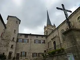
Saint-Pal-de-Chalencon
Saint-Pal-de-Chalencon is a commune in the Haute-Loire department in south-central France.
Saint-Pal-de-Chalencon | |
|---|---|
Commune | |
 | |
 Coat of arms | |
Location of Saint-Pal-de-Chalencon 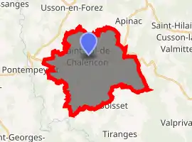
| |
 Saint-Pal-de-Chalencon  Saint-Pal-de-Chalencon | |
| Coordinates: 45°21′27″N 3°57′27″E | |
| Country | France |
| Region | Auvergne-Rhône-Alpes |
| Department | Haute-Loire |
| Arrondissement | Yssingeaux |
| Canton | Plateau du Haut-Velay granitique |
| Government | |
| • Mayor (2014–2020) | Pierre Brun |
| Area 1 | 28.95 km2 (11.18 sq mi) |
| Population (2017-01-01)[1] | 1,016 |
| • Density | 35/km2 (91/sq mi) |
| Time zone | UTC+01:00 (CET) |
| • Summer (DST) | UTC+02:00 (CEST) |
| INSEE/Postal code | 43212 /43500 |
| Elevation | 700–978 m (2,297–3,209 ft) (avg. 878 m or 2,881 ft) |
| 1 French Land Register data, which excludes lakes, ponds, glaciers > 1 km2 (0.386 sq mi or 247 acres) and river estuaries. | |
Population
| Year | Pop. | ±% |
|---|---|---|
| 1793 | 1,793 | — |
| 1806 | 2,338 | +30.4% |
| 1821 | 2,192 | −6.2% |
| 1831 | 2,416 | +10.2% |
| 1841 | 2,467 | +2.1% |
| 1851 | 2,485 | +0.7% |
| 1861 | 2,541 | +2.3% |
| 1872 | 2,222 | −12.6% |
| 1881 | 2,154 | −3.1% |
| 1891 | 2,277 | +5.7% |
| 1901 | 2,156 | −5.3% |
| 1911 | 2,070 | −4.0% |
| 1921 | 1,743 | −15.8% |
| 1931 | 1,635 | −6.2% |
| 1946 | 1,454 | −11.1% |
| 1954 | 1,368 | −5.9% |
| 1962 | 1,301 | −4.9% |
| 1968 | 1,206 | −7.3% |
| 1975 | 1,039 | −13.8% |
| 1982 | 1,043 | +0.4% |
| 1990 | 1,029 | −1.3% |
| 1999 | 1,046 | +1.7% |
| 2008 | 1,009 | −3.5% |
| 2017 | 1,016 | +0.7% |
References
- "Populations légales 2017". INSEE. Retrieved 6 January 2020.
| Wikimedia Commons has media related to Saint-Pal-de-Chalencon. |
| Authority control |
|---|
This article is issued from Wikipedia. The text is licensed under Creative Commons - Attribution - Sharealike. Additional terms may apply for the media files.