National Register of Historic Places listings in Carroll County, Virginia
This is a list of the National Register of Historic Places listings in Carroll County, Virginia.
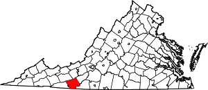
Location of Carroll County in Virginia
This is intended to be a complete list of the properties and districts on the National Register of Historic Places in Carroll County, Virginia, United States. The locations of National Register properties and districts for which the latitude and longitude coordinates are included below, may be seen in an online map.[1]
There are 9 properties and districts listed on the National Register in the county.
- This National Park Service list is complete through NPS recent listings posted January 29, 2021.[2]
Current listings
| [3] | Name on the Register[4] | Image | Date listed[5] | Location | City or town | Description |
|---|---|---|---|---|---|---|
| 1 | Sidna Allen House |  Sidna Allen House |
July 15, 1974 (#74002112) |
North of Fancy Gap on U.S. Route 52 36°41′35″N 80°41′36″W |
Fancy Gap | |
| 2 | Buffalo Mountain Presbyterian Church and Cemetery | 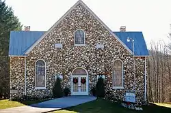 Buffalo Mountain Presbyterian Church and Cemetery |
March 30, 2007 (#07000229) |
2102 Childress Rd. 36°46′39″N 80°31′04″W |
Willis | Church is in Carroll County; cemetery is in Floyd County |
| 3 | Carroll County Courthouse |  Carroll County Courthouse |
July 8, 1982 (#82004549) |
515 Main St. 36°45′59″N 80°44′11″W |
Hillsville | |
| 4 | Carter Hydraulic Rams |  Carter Hydraulic Rams |
November 21, 2002 (#02001373) |
Off Grayson St. and U.S. Route 221 36°46′03″N 80°43′56″W |
Hillsville | |
| 5 | Dinwiddie Presbyterian Church and Cemetery |  Dinwiddie Presbyterian Church and Cemetery |
March 30, 2007 (#07000228) |
2698 Homestead Rd. 36°51′46″N 80°43′02″W |
Hillsville | |
| 6 | Hillsville Historic District |  Hillsville Historic District |
May 16, 2002 (#02000522) |
300-500 blocks of Main St. 36°45′56″N 80°44′13″W |
Hillsville | |
| 7 | Point Pleasant School | 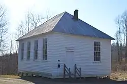 Point Pleasant School |
October 31, 2007 (#07001133) |
Laurel Fork Rd. 36°43′40″N 80°33′24″W |
Laurel Fork | |
| 8 | Snake Creek Farm Historic District |  Snake Creek Farm Historic District |
January 11, 1991 (#90002138) |
Snake Creek Rd. south of its junction with Red Hill Rd. 36°42′53″N 80°38′52″W |
Hillsville | |
| 9 | Woodlawn School |  Woodlawn School |
January 17, 2019 (#100003322) |
745 Woodlawn Rd. 36°43′39″N 80°49′06″W |
Woodlawn |
See also
| Wikimedia Commons has media related to National Register of Historic Places in Carroll County, Virginia. |
References
- The latitude and longitude information provided in this table was derived originally from the National Register Information System, which has been found to be fairly accurate for about 99% of listings. Some locations in this table may have been corrected to current GPS standards.
- "National Register of Historic Places: Weekly List Actions". National Park Service, United States Department of the Interior. Retrieved on January 29, 2021.
- Numbers represent an alphabetical ordering by significant words. Various colorings, defined here, differentiate National Historic Landmarks and historic districts from other NRHP buildings, structures, sites or objects.
- "National Register Information System". National Register of Historic Places. National Park Service. April 24, 2008.
- The eight-digit number below each date is the number assigned to each location in the National Register Information System database, which can be viewed by clicking the number.
Municipalities and communities of Carroll County, Virginia, United States | ||
|---|---|---|
| Town | Map of Virginia highlighting Carroll County | |
| CDPs | ||
| Unincorporated communities | ||
| ||
This article is issued from Wikipedia. The text is licensed under Creative Commons - Attribution - Sharealike. Additional terms may apply for the media files.