National Register of Historic Places listings in Orange County, Virginia
This is a list of the National Register of Historic Places listings in Orange County, Virginia.
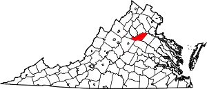
Location of Orange County in Virginia
This is intended to be a complete list of the properties and districts on the National Register of Historic Places in Orange County, Virginia, United States. The locations of National Register properties and districts for which the latitude and longitude coordinates are included below, may be seen in an online map.[1]
There are 36 properties and districts listed on the National Register in the county, including 1 National Historic Landmark.
- This National Park Service list is complete through NPS recent listings posted January 29, 2021.[2]
Current listings
| [3] | Name on the Register[4] | Image | Date listed[5] | Location | City or town | Description |
|---|---|---|---|---|---|---|
| 1 | Ballard-Marshall House |  Ballard-Marshall House |
October 27, 1988 (#88002138) |
158 E. Main St. 38°14′45″N 78°06′30″W |
Orange | |
| 2 | Barboursville |  Barboursville |
November 12, 1969 (#69000267) |
South of the junction of Vineyard Rd. and Governor Barbour St. 38°09′45″N 78°16′51″W |
Barboursville | |
| 3 | Berry Hill |  Berry Hill |
May 7, 1980 (#80004208) |
South of Orange on Old Gordonsville Rd. 38°14′18″N 78°06′27″W |
Orange | |
| 4 | Black Meadow | .jpg.webp) Black Meadow |
November 16, 2005 (#05001262) |
17379 Wolf Trap Dr. 38°10′03″N 78°08′31″W |
Gordonsville | |
| 5 | Bloomsbury |  Bloomsbury |
February 27, 1992 (#92000044) |
Off State Route 20, west of its junction with Mt. Sharon Rd. 38°15′23″N 78°03′18″W |
Orange | |
| 6 | Burlington |  Burlington |
January 11, 1994 (#93001458) |
6400 State Route 20 38°10′45″N 78°15′38″W |
Barboursville | |
| 7 | Chestnut Hill |  Chestnut Hill |
June 11, 2009 (#09000417) |
236 Caroline St. 38°14′21″N 78°06′51″W |
Orange | |
| 8 | Exchange Hotel |  Exchange Hotel |
August 14, 1973 (#73002046) |
S. Main St. 38°08′08″N 78°11′10″W |
Gordonsville | |
| 9 | Frascati |  Frascati |
June 28, 1982 (#82004579) |
South of Somerset on State Route 231 38°11′35″N 78°12′43″W |
Somerset | |
| 10 | Germanna Site | 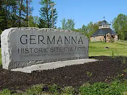 Germanna Site |
August 24, 1978 (#78003036) |
2062 State Route 3 38°22′56″N 77°46′50″W |
Culpeper | |
| 11 | Gordonsville Historic District | _between_Market_Street_and_Mayhugh_Street_in_Gordonsville%252C_Orange_County%252C_Virginia.jpg.webp) Gordonsville Historic District |
October 13, 1983 (#83004250) |
U.S. Route 15 and vicinity 38°08′20″N 78°11′17″W |
Gordonsville | |
| 12 | Greenwood |  Greenwood |
December 17, 1992 (#92001702) |
13011 Greenwood Rd. 38°13′45″N 78°08′23″W |
Orange | |
| 13 | Grelen |  Grelen |
February 13, 1998 (#98000049) |
15149 Grelen Dr. 38°16′32″N 78°06′52″W |
Orange | |
| 14 | Hampstead Farm Archeological District |  Hampstead Farm Archeological District |
August 16, 1984 (#84003559) |
Scuffletown Rd. 38°13′46″N 78°14′42″W |
Barboursville | |
| 15 | Hare Forest Farm | January 28, 1992 (#91002016) |
Trimmers Rd., west of its junction with Rapidan Rd. 38°17′14″N 78°04′53″W |
Orange | ||
| 16 | Lessland |  Lessland |
August 5, 1999 (#99000965) |
4256 Bushy Mountain Rd. 38°20′41″N 77°58′20″W |
Culpeper | |
| 17 | Madison-Barbour Rural Historic District | 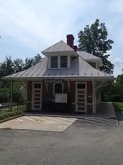 Madison-Barbour Rural Historic District |
January 17, 1991 (#90002115) |
Roughly bounded by U.S. Route 15, the Rapidan River, and the Albemarle and Greene county lines 38°11′56″N 78°13′37″W |
Barboursville | |
| 18 | Mayhurst | 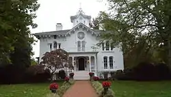 Mayhurst |
November 12, 1969 (#69000268) |
Southwest of the junction of U.S. Route 15 and Old Gordonsville Rd. 38°13′58″N 78°07′03″W |
Orange | |
| 19 | Montpelier | .jpg.webp) Montpelier |
October 15, 1966 (#66000843) |
4 miles (6.4 km) west of Orange on State Route 20 38°13′08″N 78°10′06″W |
Orange | Residence of President James Madison |
| 20 | Mount Calvary Baptist Church |  Mount Calvary Baptist Church |
November 22, 2016 (#16000799) |
11229 Kendall Rd. 38°15′03″N 78°01′07″W |
Orange | |
| 21 | Mount Sharon |  Mount Sharon |
September 9, 2013 (#13000710) |
19184 Mount Sharon Ln. 38°16′21″N 78°02′29″W |
Orange | |
| 22 | Old Manse |  Old Manse |
February 1, 2018 (#100001498) |
171 Landon Ln. 38°14′59″N 78°06′19″W |
Orange | |
| 23 | Orange Commercial Historic District |  Orange Commercial Historic District |
January 21, 1999 (#98001651) |
Roughly along Madison and Main Sts. 38°14′42″N 78°06′42″W |
Orange | |
| 24 | Orange County Courthouse |  Orange County Courthouse |
December 28, 1979 (#79003062) |
Madison Rd. and N. Main St. 38°14′43″N 78°06′41″W |
Orange | |
| 25 | Orange High School |  Orange High School |
July 5, 2001 (#01000692) |
224 Belleview Ave. 38°14′56″N 78°06′54″W |
Orange | |
| 26 | Orange Springs |  Orange Springs |
February 27, 1992 (#90002134) |
Orange Springs Rd., east of its junction with U.S. Route 522 38°11′06″N 77°55′53″W |
Unionville | |
| 27 | Rapidan Historic District |  Rapidan Historic District |
May 8, 1987 (#87000723) |
Junction of Locust Dale, Rapidan, and Old Rapidan Rds. 38°18′46″N 78°03′58″W |
Rapidan | |
| 28 | Rebel Hall |  Rebel Hall |
March 13, 2002 (#02000179) |
151 May-Fray Ave. 38°14′50″N 78°06′36″W |
Orange | |
| 29 | Rocklands |  Rocklands |
September 23, 1982 (#82004578) |
North of Gordonsville on State Route 231 38°10′07″N 78°11′38″W |
Gordonsville | |
| 30 | Rockwood |  Rockwood |
July 5, 2001 (#01000695) |
12225 Chicken Mountain Rd. 38°12′34″N 78°09′23″W |
Montpelier Station | |
| 31 | St. Thomas Church |  St. Thomas Church |
December 6, 1976 (#76002115) |
119 Caroline St. 38°14′38″N 78°06′47″W |
Orange | |
| 32 | Somerset Christian Church |  Somerset Christian Church |
February 28, 1979 (#79003061) |
State Route 20 38°13′34″N 78°13′29″W |
Old Somerset | |
| 33 | Tetley |  Tetley |
February 5, 1991 (#91000018) |
Liberty Mills Rd., east of its junction with State Route 231 38°14′23″N 78°12′13″W |
Somerset | |
| 34 | Waddell Memorial Presbyterian Church | Waddell Memorial Presbyterian Church |
August 28, 1975 (#75002028) |
Southeast of Rapidan on Rapidan Rd. 38°18′30″N 78°03′45″W |
Rapidan | |
| 35 | Willow Grove |  Willow Grove |
May 7, 1979 (#79003063) |
2 miles (3.2 km) northwest of Orange on U.S. Route 15 38°16′24″N 78°07′55″W |
Madison Mills | |
| 36 | Williston |  Williston |
November 16, 2005 (#05001270) |
13430 State Route 20 38°14′24″N 78°08′13″W |
Orange |
See also
| Wikimedia Commons has media related to National Register of Historic Places in Orange County, Virginia. |
References
- The latitude and longitude information provided in this table was derived originally from the National Register Information System, which has been found to be fairly accurate for about 99% of listings. Some locations in this table may have been corrected to current GPS standards.
- "National Register of Historic Places: Weekly List Actions". National Park Service, United States Department of the Interior. Retrieved on January 29, 2021.
- Numbers represent an alphabetical ordering by significant words. Various colorings, defined here, differentiate National Historic Landmarks and historic districts from other NRHP buildings, structures, sites or objects.
- "National Register Information System". National Register of Historic Places. National Park Service. April 24, 2008.
- The eight-digit number below each date is the number assigned to each location in the National Register Information System database, which can be viewed by clicking the number.
Municipalities and communities of Orange County, Virginia, United States | ||
|---|---|---|
| Towns | Map of Virginia highlighting Orange County | |
| CDP | ||
| Unincorporated communities | ||
| Footnotes | ‡This populated place also has portions in an adjacent county or counties | |
| ||
This article is issued from Wikipedia. The text is licensed under Creative Commons - Attribution - Sharealike. Additional terms may apply for the media files.