National Register of Historic Places listings in Rockingham County, Virginia
This is a list of the National Register of Historic Places listings in Rockingham County, Virginia.
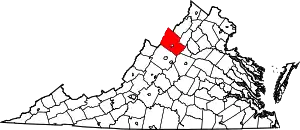
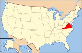
Location of Rockingham County in Virginia
This is intended to be a complete list of the properties and districts on the National Register of Historic Places in Rockingham County, Virginia, United States. The locations of National Register properties and districts for which the latitude and longitude coordinates are included below, may be seen in an online map.[1]
There are 43 properties and districts listed on the National Register in the county, including 1 National Historic Landmark.
- This National Park Service list is complete through NPS recent listings posted January 29, 2021.[2]
Current listings
| [3] | Name on the Register[4] | Image | Date listed[5] | Location | City or town | Description |
|---|---|---|---|---|---|---|
| 1 | Baxter House |  Baxter House |
October 3, 1973 (#73002057) |
North of Harrisonburg on State Route 42 38°33′21″N 78°50′09″W |
Edom | |
| 2 | John K. Beery Farm |  John K. Beery Farm |
September 19, 1973 (#73002058) |
North of Harrisonburg off State Route 42 38°31′08″N 78°51′31″W |
Edom | |
| 3 | Bethlehem Church |  Bethlehem Church |
June 27, 1985 (#85001414) |
Tenth Legion Rd. 38°34′39″N 78°43′56″W |
Broadway | |
| 4 | Big Run Quarry Site | December 13, 1985 (#85003177) |
Address Restricted |
Luray | ||
| 5 | Bogota |  Bogota |
March 25, 2009 (#09000162) |
5375 Lynnwood Rd. 38°19′03″N 78°46′27″W |
Port Republic | |
| 6 | Bon Air |  Bon Air |
May 2, 2007 (#07000399) |
2477 Bear Lithia Rd. 38°26′10″N 78°37′08″W |
Elkton | |
| 7 | Breneman-Turner Mill | 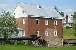 Breneman-Turner Mill |
April 20, 2006 (#06000325) |
5036 Turners Mill Ln. 38°31′30″N 78°52′30″W |
Harrisonburg | |
| 8 | Bridgewater Historic District |  Bridgewater Historic District |
November 1, 1984 (#84000477) |
Roughly Main St. from the North River to Crawford Ave., and E. College, Gravel Lane, and Bank St. 38°22′56″N 78°58′36″W |
Bridgewater | |
| 9 | Cave Hill Farm |  Cave Hill Farm |
November 18, 2011 (#11000839) |
9780 Cave Hill Rd. 38°21′34″N 78°43′18″W |
McGaheysville | |
| 10 | George Chrisman House |  George Chrisman House |
December 1, 2006 (#06001099) |
5341 Shaver Mill Rd. 38°32′42″N 78°52′04″W |
Linville | |
| 11 | Contentment |  Contentment |
May 19, 2004 (#04000481) |
253 Contentment Ln. 38°20′32″N 78°56′06″W |
Mount Crawford | |
| 12 | Dayton Historic District |  Dayton Historic District |
August 16, 1984 (#84003590) |
Roughly bounded by Main, Mason, Walnut, Summit, and Bowman Sts. 38°24′58″N 78°56′27″W |
Dayton | |
| 13 | Deering Hall | August 25, 2020 (#100005530) |
140 North Main St. 38°36′51″N 78°47′55″W |
Broadway | ||
| 14 | David and Catherine Driver Farm |  David and Catherine Driver Farm |
May 8, 2007 (#07000415) |
3796 Long Meadow Dr. 38°37′20″N 78°45′18″W |
Timberville | |
| 15 | Edom Store and Post Office |  Edom Store and Post Office |
July 24, 2007 (#07000768) |
5375 Jesse Bennett Way 38°31′31″N 78°51′36″W |
Edom | |
| 16 | Joseph Funk House | 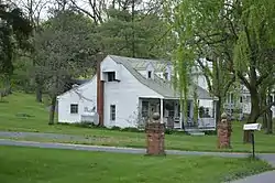 Joseph Funk House |
February 24, 1975 (#75002036) |
Singers Glen Rd. 38°33′04″N 78°55′03″W |
Singers Glen | |
| 17 | Harnsberger Farm |  Harnsberger Farm |
January 22, 1992 (#91001974) |
Junction of Point and Rinacas Corner Rds. 38°28′35″N 78°38′08″W |
Shenandoah | |
| 18 | Stephen Harnsberger House |  Stephen Harnsberger House |
July 8, 1982 (#82004593) |
Holly Ave. 38°16′31″N 78°49′48″W |
Grottoes | |
| 19 | Daniel Harrison House | 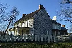 Daniel Harrison House |
July 24, 1973 (#73002056) |
Northeast of Dayton on State Route 42 38°25′05″N 78°56′09″W |
Dayton | |
| 20 | Haugh House |  Haugh House |
August 18, 2011 (#11000552) |
6529 State Route 253 38°21′05″N 78°49′27″W |
Port Republic | |
| 21 | Inglewood |  Inglewood |
May 30, 1985 (#85001172) |
Kratzler Rd. 38°28′51″N 78°50′43″W |
Harrisonburg | |
| 22 | Kite Mansion |  Kite Mansion |
February 13, 2007 (#07000049) |
17271 U.S. Route 33 38°24′12″N 78°36′15″W |
Elkton | |
| 23 | Kyle's Mill House |  Kyle's Mill House |
March 6, 2001 (#01000142) |
1764 Cross Keys Rd. 38°22′20″N 78°49′37″W |
Harrisonburg | |
| 24 | Lincoln Homestead and Cemetery |  Lincoln Homestead and Cemetery |
December 5, 1972 (#72001414) |
South of the junction of State Route 42 and Klines Mill Rd. 38°33′32″N 78°50′04″W |
Broadway | |
| 25 | Linville Creek Bridge | .jpg.webp) Linville Creek Bridge |
April 15, 1978 (#78003042) |
South of Broadway on Springbrook Rd. 38°36′23″N 78°48′11″W |
Broadway | |
| 26 | Long Meadow |  Long Meadow |
June 1, 2005 (#05000528) |
2525 Fridleys Gap Rd. 38°30′55″N 78°44′34″W |
Harrisonburg | |
| 27 | Longs Chapel |  Longs Chapel |
November 15, 2006 (#06001042) |
1334B Fridleys Gap Rd. 38°30′46″N 78°45′46″W |
Harrisonburg | |
| 28 | Mannheim (082-0005) | 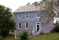 Mannheim (082-0005) |
May 27, 2004 (#04000553) |
4713 Wengers Mill Rd. 38°32′53″N 78°50′50″W |
Linville | |
| 29 | Massanetta Springs Historic District |  Massanetta Springs Historic District |
May 26, 2005 (#05000477) |
712 Massanetta Springs Rd. 38°24′03″N 78°50′10″W |
Harrisonburg | |
| 30 | Melrose Caverns and Harrison Farmstead | 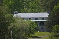 Melrose Caverns and Harrison Farmstead |
May 14, 2014 (#14000237) |
6639 N. U.S. Route 11 38°31′02″N 78°47′25″W |
Harrisonburg | |
| 31 | Miller-Kite House | 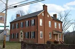 Miller-Kite House |
February 1, 1979 (#79003083) |
302 Rockingham St. 38°24′32″N 78°36′57″W |
Elkton | Headquarters of Confederate General Stonewall Jackson during the Shenandoah Valley Campaign of the American Civil War |
| 32 | Paul's Ottobine Mill |  Paul's Ottobine Mill |
June 12, 2017 (#100001083) |
8061 Judge Paul Rd. 38°25′44″N 79°02′15″W |
Dayton | |
| 33 | Peter Paul House |  Peter Paul House |
December 28, 1979 (#79003082) |
North of Dayton on Silver Lake Rd. 38°25′48″N 78°56′19″W |
Dayton | |
| 34 | Jonathan Peale House |  Jonathan Peale House |
November 1, 2007 (#07001144) |
67 Cross Keys Rd. 38°23′31″N 78°48′39″W |
Harrisonburg | |
| 35 | Plains Mill |  Plains Mill |
May 19, 2014 (#14000238) |
14767 Plains Mill Rd. 38°38′49″N 78°43′14″W |
Timberville | |
| 36 | Port Republic Historic District |  Port Republic Historic District |
September 8, 1980 (#80004224) |
State Route 253 and Main St. 38°17′39″N 78°48′56″W |
Port Republic | |
| 37 | Silver Lake Historic District |  Silver Lake Historic District |
May 22, 2019 (#100003978) |
Silver Lake and Linhoss Rds. 38°25′20″N 78°56′24″W |
Dayton | |
| 38 | Singers Glen Historic District |  Singers Glen Historic District |
January 20, 1978 (#78003043) |
Junction of Green Hill and Singers Glen Rds. 38°33′09″N 78°54′50″W |
Singers Glen | |
| 39 | Sites House |  Sites House |
April 3, 1979 (#79003081) |
Southwest of Broadway off Sunset Dr. 38°35′40″N 78°49′40″W |
Broadway | |
| 40 | Skyline Drive Historic District | 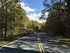 Skyline Drive Historic District |
April 28, 1997 (#97001112) |
Shenandoah National Park, from the northern entrance station at Front Royal to the southern entrance station at the Rockfish Gap 38°22′03″N 78°32′12″W |
Luray | |
| 41 | Taylor Springs |  Taylor Springs |
June 6, 2002 (#02000621) |
3712 Taylor Spring Ln. 38°23′40″N 78°50′18″W |
Harrisonburg | |
| 42 | Timberville Historic District | _at_Rockingham_Street_in_Timberville%252C_Rockingham_County%252C_Virginia.jpg.webp) Timberville Historic District |
January 2, 2013 (#12001137) |
Bounded by Main, Bellevue, Montevideo, High, Church, and S. C Sts., and Maple Ave. 38°38′20″N 78°46′24″W |
Timberville | |
| 43 | Tunker House |  Tunker House |
July 2, 1971 (#71000989) |
South of central Broadway on Lindsay Ave. 38°36′16″N 78°47′54″W |
Broadway |
See also
| Wikimedia Commons has media related to National Register of Historic Places in Rockingham County, Virginia. |
References
- The latitude and longitude information provided in this table was derived originally from the National Register Information System, which has been found to be fairly accurate for about 99% of listings. Some locations in this table may have been corrected to current GPS standards.
- "National Register of Historic Places: Weekly List Actions". National Park Service, United States Department of the Interior. Retrieved on January 29, 2021.
- Numbers represent an alphabetical ordering by significant words. Various colorings, defined here, differentiate National Historic Landmarks and historic districts from other NRHP buildings, structures, sites or objects.
- "National Register Information System". National Register of Historic Places. National Park Service. April 24, 2008.
- The eight-digit number below each date is the number assigned to each location in the National Register Information System database, which can be viewed by clicking the number.
Municipalities and communities of Rockingham County, Virginia, United States | ||
|---|---|---|
| Towns | Map of Virginia highlighting Rockingham County | |
| CDPs | ||
| Unincorporated communities |
| |
| Footnotes | ‡This populated place also has portions in an adjacent county or counties | |
| ||
This article is issued from Wikipedia. The text is licensed under Creative Commons - Attribution - Sharealike. Additional terms may apply for the media files.