National Register of Historic Places listings in Henry County, Virginia
This is a list of the National Register of Historic Places listings in Henry County, Virginia.

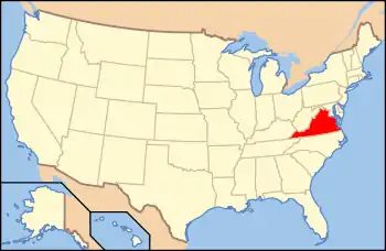
Location of Henry County in Virginia
This is intended to be a complete list of the properties and districts on the National Register of Historic Places in Henry County, Virginia, United States. The locations of National Register properties and districts for which the latitude and longitude coordinates are included below, may be seen in an online map.[1]
There are 18 properties and districts listed on the National Register in the county.
- This National Park Service list is complete through NPS recent listings posted January 29, 2021.[2]
Current listings
| [3] | Name on the Register[4] | Image | Date listed[5] | Location | City or town | Description |
|---|---|---|---|---|---|---|
| 1 | John D. Bassett High School |  John D. Bassett High School |
February 3, 2006 (#05001587) |
State Route 57 36°45′44″N 79°59′47″W |
Bassett | |
| 2 | Beaver Creek Plantation | 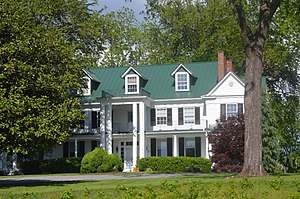 Beaver Creek Plantation |
May 9, 1985 (#85000984) |
State Route 108 36°43′11″N 79°52′53″W |
Martinsville | |
| 3 | Belleview |  Belleview |
June 10, 1974 (#74002129) |
South of the Joseph Martin Highway 36°36′28″N 79°53′17″W |
Ridgeway | |
| 4 | Edgewood |  Edgewood |
March 29, 2007 (#07000231) |
150 Old Stage Rd. 36°44′19″N 79°57′03″W |
Stanleytown | |
| 5 | Eltham Manor |  Eltham Manor |
August 5, 1999 (#99000960) |
405 Riverside Dr. 36°44′06″N 79°57′47″W |
Bassett | |
| 6 | Fairy Stone State Park Historic District | .jpg.webp) Fairy Stone State Park Historic District |
April 10, 2007 (#07000338) |
967 Fairystone Lake Dr. 36°47′48″N 80°07′00″W |
Stuart | |
| 7 | Fieldale Historic District |  Fieldale Historic District |
February 22, 2008 (#08000072) |
Roughly bounded by 10th St., River Rd., Patrick Ave., and Chestnut St. 36°41′59″N 79°56′18″W |
Fieldale | |
| 8 | Grassdale Farm |  Grassdale Farm |
May 30, 2002 (#02000587) |
187 Spencer Penn Rd. 36°37′02″N 80°00′33″W |
Spencer | |
| 9 | The Highlands |  The Highlands |
February 13, 2018 (#100002136) |
510 Edgewood Dr. 36°44′16″N 79°56′53″W |
Stanleytown | |
| 10 | Ingleside |  Ingleside |
August 5, 1999 (#99000963) |
500 Mica Rd. 36°35′48″N 79°51′23″W |
Ridgeway | |
| 11 | Marshall Field and Company Clubhouse | 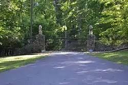 Marshall Field and Company Clubhouse |
June 1, 2005 (#05000523) |
2692 River Rd. 36°41′35″N 79°55′48″W |
Fieldale | |
| 12 | Martinsville Fish Dam |  Martinsville Fish Dam |
January 21, 1974 (#74002128) |
Smith River below the Rives Rd. bridge[6] 36°39′14″N 79°52′17″W |
Martinsville | |
| 13 | Old Turner Place |  Old Turner Place |
November 21, 2002 (#02001371) |
7643 Henry Rd. 36°49′44″N 79°59′55″W |
Henry | |
| 14 | Rock Run School |  Rock Run School |
November 16, 2005 (#05001268) |
532 John Baker Rd. 36°43′00″N 79°58′52″W |
Fieldale | |
| 15 | Spencer-Penn School |  Spencer-Penn School |
May 26, 2005 (#05000482) |
30 George Taylor Rd. 36°36′54″N 80°00′49″W |
Spencer | |
| 16 | R.L. Stone House |  R.L. Stone House |
August 16, 2006 (#06000708) |
3136 State Route 57 36°45′20″N 79°59′05″W |
Bassett | |
| 17 | Stoneleigh | 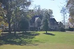 Stoneleigh |
November 24, 1982 (#82001820) |
Oak Level Rd. 36°44′05″N 79°56′48″W |
Stanleytown | |
| 18 | Virginia Home |  Virginia Home |
May 24, 2000 (#00000495) |
986 Field Ave. 36°42′20″N 79°56′23″W |
Fieldale |
See also
| Wikimedia Commons has media related to National Register of Historic Places in Henry County, Virginia. |
References
- The latitude and longitude information provided in this table was derived originally from the National Register Information System, which has been found to be fairly accurate for about 99% of listings. Some locations in this table may have been corrected to current GPS standards.
- "National Register of Historic Places: Weekly List Actions". National Park Service, United States Department of the Interior. Retrieved on January 29, 2021.
- Numbers represent an alphabetical ordering by significant words. Various colorings, defined here, differentiate National Historic Landmarks and historic districts from other NRHP buildings, structures, sites or objects.
- "National Register Information System". National Register of Historic Places. National Park Service. April 24, 2008.
- The eight-digit number below each date is the number assigned to each location in the National Register Information System database, which can be viewed by clicking the number.
- Martinsville Fish Dam on Smith River, Virginia Tourism Corporation, 2017. Accessed 2017-03-28.
Municipalities and communities of Henry County, Virginia, United States | ||
|---|---|---|
| Town | Map of Virginia highlighting Henry County | |
| CDPs | ||
| Unincorporated communities | ||
| ||
This article is issued from Wikipedia. The text is licensed under Creative Commons - Attribution - Sharealike. Additional terms may apply for the media files.