National Register of Historic Places listings in Garrett County, Maryland
This is a list of the National Register of Historic Places listings in Garrett County, Maryland.
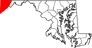
Location of Garrett County in Maryland
This is intended to be a complete list of the properties and districts on the National Register of Historic Places in Garrett County, Maryland, United States. Latitude and longitude coordinates are provided for many National Register properties and districts; these locations may be seen together in a map.[1]
There are 20 properties and districts listed on the National Register in the county, including 1 National Historic Landmark.
| Allegany - Anne Arundel - Baltimore (city) - Baltimore County - Calvert - Caroline - Carroll - Cecil - Charles - Dorchester - Frederick - Garrett - Harford - Howard - Kent - Montgomery - Prince George's - Queen Anne's - Somerset - St. Mary's - Talbot - Washington - Wicomico - Worcester |
- This National Park Service list is complete through NPS recent listings posted January 29, 2021.[2]
Current listings
| [3] | Name on the Register[4] | Image | Date listed[5] | Location | City or town | Description |
|---|---|---|---|---|---|---|
| 1 | Anderson Chapel |  Anderson Chapel |
June 7, 1984 (#84001775) |
Swanton Hill and Pine Hill Rds. 39°27′34″N 79°13′53″W |
Swanton | |
| 2 | Baltimore and Ohio Railroad Station, Oakland |  Baltimore and Ohio Railroad Station, Oakland |
February 5, 1974 (#74000953) |
Liberty St. 39°24′35″N 79°24′47″W |
Oakland | |
| 3 | Bloomington Viaduct | 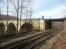 Bloomington Viaduct |
November 21, 1976 (#76000996) |
Over the Potomac River south of Maryland Route 135 39°28′37″N 79°04′05″W |
Bloomington | |
| 4 | Borderside | October 29, 1975 (#75000898) |
Oakland-Westernport Rd. 39°28′43″N 79°04′21″W |
Bloomington | ||
| 5 | Casselman's Bridge, National Road |  Casselman's Bridge, National Road |
October 15, 1966 (#66000391) |
East of Grantsville on U.S. Route 40 39°41′48″N 79°08′37″W |
Grantsville | |
| 6 | Creedmore |  Creedmore |
December 27, 1984 (#84000505) |
510 G St. 39°23′59″N 79°22′59″W |
Mountain Lake Park | |
| 7 | James Drane House | 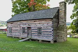 James Drane House |
January 11, 1985 (#85000059) |
Accident-Bittinger Rd. 39°37′45″N 79°18′47″W |
Accident | |
| 8 | Fuller-Baker Log House |  Fuller-Baker Log House |
February 12, 1971 (#71000375) |
0.5 miles west of Grantsville on U.S. Route 40 39°41′45″N 79°10′20″W |
Grantsville | |
| 9 | Garrett County Courthouse |  Garrett County Courthouse |
November 12, 1975 (#75000899) |
3rd and Alder Sts. 39°24′26″N 79°24′25″W |
Oakland | |
| 10 | Glamorgan | September 13, 1984 (#84001778) |
Maryland Route 135 39°25′46″N 79°19′29″W |
Deer Park | ||
| 11 | Hoye Site |  Hoye Site |
May 12, 1975 (#75000900) |
Address Restricted |
Oakland | |
| 12 | Inns on the National Road | 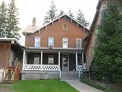 Inns on the National Road |
December 22, 1976 (#76000976) |
East and west of Cumberland on U.S. Route 40 from Flintstone to Grantsville 39°41′49″N 79°08′31″W |
Grantsville | |
| 13 | Kaese Mill |  Kaese Mill |
September 13, 1984 (#84001782) |
North of Accident 39°39′02″N 79°17′49″W |
Accident | |
| 14 | Mercy Chapel at Mill Run |  Mercy Chapel at Mill Run |
September 7, 1984 (#84001792) |
Mill Run Rd. 39°42′40″N 79°22′19″W |
Selbysport | |
| 15 | Meyer Site | June 19, 1973 (#73000921) |
Address Restricted |
Westernport | ||
| 16 | Mountain Lake Park Historic District |  Mountain Lake Park Historic District |
September 1, 1983 (#83002948) |
Roughly bounded by Alleghany Dr., Oakland Ave., and D and N Sts. 39°23′49″N 79°22′53″W |
Mountain Lake Park | |
| 17 | Oakland Historic District | 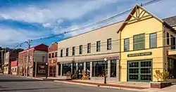 Oakland Historic District |
January 26, 1984 (#84001798) |
Roughly bounded by Oak, 8th, High, 3rd, Omaha, and Bartlet Sts. 39°24′35″N 79°24′20″W |
Oakland | |
| 18 | Pennington Cottage |  Pennington Cottage |
May 17, 1976 (#76000997) |
Deer Park Hotel Rd. 39°25′12″N 79°20′00″W |
Deer Park | |
| 19 | Stanton's Mill |  Stanton's Mill |
January 17, 1983 (#83002949) |
East of Grantsville on U.S. Route 40 39°41′48″N 79°08′25″W |
Grantsville | |
| 20 | Tomlinson Inn and the Little Meadows | 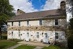 Tomlinson Inn and the Little Meadows |
September 20, 1973 (#73000920) |
3 miles east of Grantsville on U.S. Route 40 39°41′37″N 79°05′46″W |
Grantsville |
See also
| Wikimedia Commons has media related to National Register of Historic Places in Garrett County, Maryland. |
References
- The latitude and longitude information provided in this table was derived originally from the National Register Information System, which has been found to be fairly accurate for about 99% of listings. Some locations in this table may have been corrected to current GPS standards.
- "National Register of Historic Places: Weekly List Actions". National Park Service, United States Department of the Interior. Retrieved on January 29, 2021.
- Numbers represent an alphabetical ordering by significant words. Various colorings, defined here, differentiate National Historic Landmarks and historic districts from other NRHP buildings, structures, sites or objects.
- "National Register Information System". National Register of Historic Places. National Park Service. April 24, 2008.
- The eight-digit number below each date is the number assigned to each location in the National Register Information System database, which can be viewed by clicking the number.
| Topics | 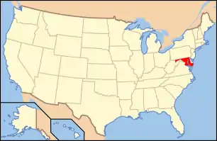 | |
|---|---|---|
| Lists by county | ||
| Lists by city | ||
| Other lists | ||
| ||
Municipalities and communities of Garrett County, Maryland, United States | ||
|---|---|---|
| Towns | | |
| CDPs | ||
| Unincorporated communities | ||
| Ghost town | ||
| Footnotes | ‡This populated place also has portions in an adjacent county or counties | |
| ||
This article is issued from Wikipedia. The text is licensed under Creative Commons - Attribution - Sharealike. Additional terms may apply for the media files.