National Register of Historic Places listings in Howard County, Maryland
This is a list of the National Register of Historic Places listings in Howard County, Maryland.
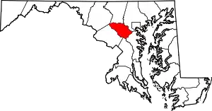
Location of Howard County in Maryland
This is intended to be a complete list of the properties and districts on the National Register of Historic Places in Howard County, Maryland, United States. Latitude and longitude coordinates are provided for many National Register properties and districts; these locations may be seen together in a map.[1]
There are 42 properties and districts listed on the National Register in the county, including 4 National Historic Landmarks.
| Allegany - Anne Arundel - Baltimore (city) - Baltimore County - Calvert - Caroline - Carroll - Cecil - Charles - Dorchester - Frederick - Garrett - Harford - Howard - Kent - Montgomery - Prince George's - Queen Anne's - Somerset - St. Mary's - Talbot - Washington - Wicomico - Worcester |
- This National Park Service list is complete through NPS recent listings posted February 5, 2021.[2]
Current listings
| [3] | Name on the Register[4] | Image | Date listed[5] | Location | City or town | Description |
|---|---|---|---|---|---|---|
| 1 | Commodore Joshua Barney House | 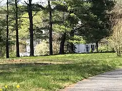 Commodore Joshua Barney House |
August 25, 1978 (#78001470) |
North of Savage at 7912 Savage-Guilford Rd. 39°09′17″N 76°49′54″W |
Savage | |
| 2 | Bollman Suspension and Trussed Bridge | 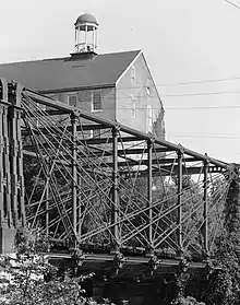 Bollman Suspension and Trussed Bridge |
October 18, 1972 (#72000582) |
Spanning the Little Patuxent River near the junction of Gorman Rd. and Foundry St. 39°08′05″N 76°49′31″W |
Savage | |
| 3 | Brick House on the Pike | 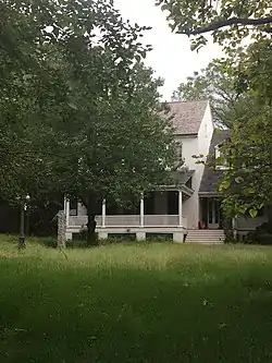 Brick House on the Pike |
January 11, 1996 (#95001522) |
9465 Baltimore National Pike 39°16′45″N 76°50′38″W |
Ellicott City | |
| 4 | Burleigh | 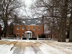 Burleigh |
November 30, 1982 (#82001596) |
3950 White Rose Way 39°15′45″N 76°52′04″W |
Ellicott City | Also known as Burleigh Manor |
| 5 | Carrollton Hall | _-_outbuilding_1.jpg.webp) Carrollton Hall |
December 16, 2014 (#14001042) |
12280 Folly Quarter Rd. 39°15′22″N 76°56′14″W |
Ellicott City | Now part of the Shrine of St. Anthony. |
| 6 | Cherry Grove, HO-1 | 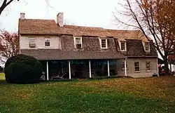 Cherry Grove, HO-1 |
June 21, 2007 (#07000567) |
2937 Jennings Chapel Rd. 39°17′39″N 77°05′38″W |
Woodbine | |
| 7 | Christ Church Guilford | 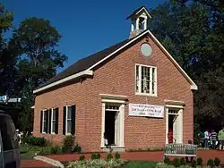 Christ Church Guilford |
January 30, 1978 (#78001469) |
North of Guilford at 6800 Oakland Mills Rd. 39°11′04″N 76°49′41″W |
Columbia | |
| 8 | Curtis-Shipley Farmstead | 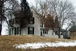 Curtis-Shipley Farmstead |
December 12, 2006 (#06001127) |
5771 Waterloo Rd. 39°12′53″N 76°48′03″W |
Ellicott City | |
| 9 | Daniels Mill |  Daniels Mill |
April 11, 1973 (#73000929) |
Daniels Rd. 39°19′02″N 76°48′47″W |
Daniels | |
| 10 | Dorsey Hall |  Dorsey Hall |
December 28, 2001 (#01001374) |
5100 Dorsey Hall Dr. 39°14′43″N 76°50′05″W |
Columbia | |
| 11 | Doughoregan Manor | 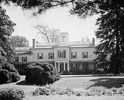 Doughoregan Manor |
November 11, 1971 (#71000376) |
8 miles west of Ellicott City on Manor Lane 39°16′37″N 76°53′25″W |
Ellicott City | |
| 12 | Elkridge Furnace Complex |  Elkridge Furnace Complex |
June 28, 1990 (#90000635) |
5730 and 5741-5745 Furnace Ave., 5735 Race Rd. 39°12′47″N 76°42′12″W |
Elkridge | |
| 13 | Ellicott City Historic District |  Ellicott City Historic District |
July 31, 1978 (#78001467) |
Maryland Route 144 39°16′11″N 76°48′00″W |
Ellicott City | |
| 14 | Ellicott City Station | 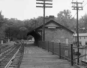 Ellicott City Station |
November 24, 1968 (#68000025) |
South of the Patapsco River Bridge 39°16′02″N 76°47′43″W |
Ellicott City | |
| 15 | Elmonte | 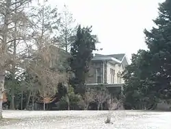 Elmonte |
August 25, 1978 (#78001468) |
9095 Furrow Avenue 39°18′28″N 76°49′25″W |
Ellicott City | |
| 16 | Enniscorthy | 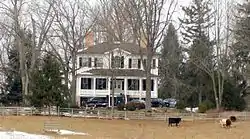 Enniscorthy |
May 8, 1986 (#86001019) |
3412 Folly Quarter Rd. 39°16′42″N 76°54′12″W |
Ellicott City | |
| 17 | Forest View | 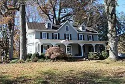 Forest View |
December 12, 2017 (#100001894) |
1805 Marriottsville Rd. 39°19′14″N 76°53′54″W |
Marriottsville vicinity | |
| 18 | Glenelg Manor | 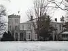 Glenelg Manor |
February 3, 1983 (#83002952) |
Southeast of Glenelg at 12793 Folly Quarter Road 39°15′06″N 76°57′41″W |
Glenelg | |
| 19 | Hobson's Choice | 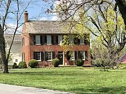 Hobson's Choice |
September 13, 1984 (#84001802) |
3145 Florence Rd. 39°18′24″N 77°05′32″W |
Woodbine | |
| 20 | Howard Lodge | 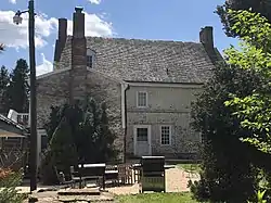 Howard Lodge |
October 9, 2012 (#12000845) |
12301 Howard Lodge Rd. 39°20′14″N 76°56′23″W |
Sykesville vicinity | |
| 21 | The Lawn | 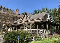 The Lawn |
October 29, 1984 (#84000412) |
6036 Old Lawyers Hill Rd. 39°13′16″N 76°43′09″W |
Elkridge | |
| 22 | Lawyers Hill Historic District | 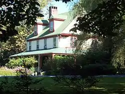 Lawyers Hill Historic District |
September 23, 1993 (#93001000) |
Area surrounding Lawyers Hill and Old Lawyers Hill Rds. and Elibank Dr. 39°13′12″N 76°43′53″W |
Elkridge | |
| 23 | Linnwood |  Linnwood |
December 12, 2006 (#06001126) |
2327 Daniels Rd. 39°18′27″N 76°48′23″W |
Ellicott City | |
| 24 | MacAlpine | 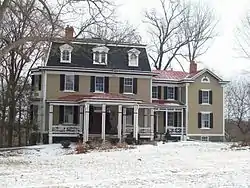 MacAlpine |
December 23, 2004 (#04001382) |
3621 Macalpine Rd. 39°16′15″N 76°49′46″W |
Ellicott City | |
| 25 | Montrose | 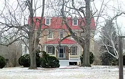 Montrose |
December 13, 2000 (#00001506) |
13370 Brighton Dam Rd. 39°12′04″N 76°58′39″W |
Clarksville | |
| 26 | Oakdale | 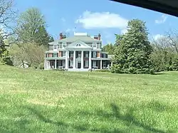 Oakdale |
December 16, 2014 (#14001041) |
16449 Ed Warfield Rd. 39°17′19″N 77°04′56″W |
Woodbine | |
| 27 | Oakland Mills Blacksmith House and Shop |  Oakland Mills Blacksmith House and Shop |
November 18, 2011 (#11000820) |
5471 Old Columbia Pike 39°13′17″N 76°50′51″W |
Columbia | |
| 28 | Old National Pike Milestones |  Old National Pike Milestones |
November 27, 1975 (#75002107) |
U.S. Route 40, Alternate U.S. Route 40, and Scenic U.S. Route 40, and Maryland Routes 44 and 165 39°25′13″N 77°16′01″W |
Lisbon | |
| 29 | Patterson Viaduct Ruins |  Patterson Viaduct Ruins |
June 3, 1976 (#76002221) |
South of Catonsville at the Patapsco River 39°15′00″N 76°45′51″W |
Ilchester | |
| 30 | Richland Farm | 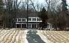 Richland Farm |
March 26, 2008 (#08000217) |
4730 Sheppard Ln. 39°14′40″N 76°56′45″W |
Clarksville | |
| 31 | Roberts Inn | 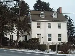 Roberts Inn |
August 2, 2006 (#06000661) |
14610 Frederick Rd. 39°19′27″N 77°01′12″W |
Cooksville | |
| 32 | Round About Hills | 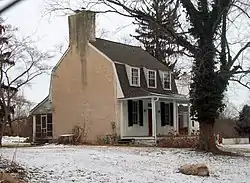 Round About Hills |
November 20, 2008 (#08001072) |
15505 Cattail Oaks 39°16′00″N 77°02′10″W |
Glenwood | |
| 33 | Savage Mill |  Savage Mill |
April 18, 1974 (#74002251) |
Southwestern corner of Foundry Rd. and Washington St. 39°08′07″N 76°49′37″W |
Savage | |
| 34 | Savage Mill Historic District | 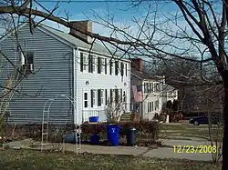 Savage Mill Historic District |
February 20, 1975 (#75000905) |
North of the Little Patuxent River off U.S. Route 1 39°08′12″N 76°49′38″W |
Savage | |
| 35 | Temora | 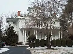 Temora |
April 30, 1976 (#76001003) |
4252 Columbia Rd. 39°15′14″N 76°49′28″W |
Ellicott City | |
| 36 | Thomas Viaduct, Baltimore & Ohio Railroad | 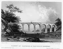 Thomas Viaduct, Baltimore & Ohio Railroad |
October 15, 1966 (#66000388) |
Over the Patapsco River between Relay and Elkridge 39°13′19″N 76°42′49″W |
Relay | |
| 37 | Trinity Church | 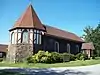 Trinity Church |
May 6, 1974 (#74000957) |
7474 Washington Boulevard 39°10′48″N 76°46′13″W |
Elkridge | |
| 38 | Troy |  Troy |
June 22, 1979 (#79001137) |
Interstate 95 and Maryland Route 176 (6500 Mansion Lane) 39°11′44″N 76°45′42″W |
Elkridge | |
| 39 | Union Chapel | 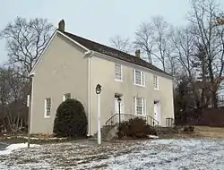 Union Chapel |
March 17, 1975 (#75000904) |
1 mile north of Glenwood on Maryland Route 97 39°17′45″N 77°01′31″W |
Glenwood | |
| 40 | Waverley | 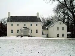 Waverley |
October 18, 1974 (#74000958) |
2335 Marriottsville Road 39°18′06″N 76°53′55″W |
Marriottsville | |
| 41 | White Hall | 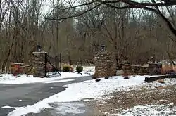 White Hall |
August 12, 1977 (#77000698) |
West of Ellicott City at 4130 Chatham Rd. 39°15′29″N 76°50′12″W |
Ellicott City | |
| 42 | Woodlawn | 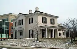 Woodlawn |
February 3, 1983 (#83002953) |
9254 Old Annapolis Rd. 39°14′05″N 76°49′33″W |
Columbia |
See also
| Wikimedia Commons has media related to National Register of Historic Places in Howard County, Maryland. |
References
- The latitude and longitude information provided in this table was derived originally from the National Register Information System, which has been found to be fairly accurate for about 99% of listings. Some locations in this table may have been corrected to current GPS standards.
- "National Register of Historic Places: Weekly List Actions". National Park Service, United States Department of the Interior. Retrieved on February 5, 2021.
- Numbers represent an alphabetical ordering by significant words. Various colorings, defined here, differentiate National Historic Landmarks and historic districts from other NRHP buildings, structures, sites or objects.
- "National Register Information System". National Register of Historic Places. National Park Service. April 24, 2008.
- The eight-digit number below each date is the number assigned to each location in the National Register Information System database, which can be viewed by clicking the number.
| Topics |  | |
|---|---|---|
| Lists by county | ||
| Lists by city | ||
| Other lists | ||
| ||
Municipalities and communities of Howard County, Maryland, United States | ||
|---|---|---|
| CDPs | | |
| Villages | ||
| Unincorporated communities |
| |
| Footnotes | ‡This populated place also has portions in an adjacent county or counties | |
| ||
This article is issued from Wikipedia. The text is licensed under Creative Commons - Attribution - Sharealike. Additional terms may apply for the media files.