National Register of Historic Places listings in Adams County, Pennsylvania
This is a list of the National Register of Historic Places listings in Adams County, Pennsylvania.

Location of Adams County in Pennsylvania
This is intended to be a complete list of the properties and districts on the National Register of Historic Places in Adams County, Pennsylvania, United States. The locations of National Register properties and districts for which the latitude and longitude coordinates are included below, may be seen in a map.[1]
There are 35 properties and districts listed on the National Register in the county. One site is further designated as a National Historic Site and another is designated as a National Military Park. Another property was once listed but has been removed.
- This National Park Service list is complete through NPS recent listings posted January 29, 2021.[2]
Current listings
| [3] | Name on the Register | Image | Date listed[4] | Location | Municipality | Description |
|---|---|---|---|---|---|---|
| 1 | John Abbott House | 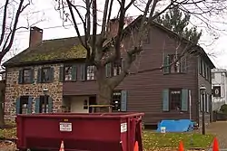 John Abbott House |
February 22, 1980 (#80003394) |
East King Street 39°53′14″N 76°58′55″W |
Abbottstown | |
| 2 | Adams County Courthouse | 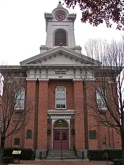 Adams County Courthouse |
October 1, 1974 (#74001728) |
Baltimore and West Middle Streets 39°49′46″N 77°13′53″W |
Gettysburg | |
| 3 | Black Horse Tavern |  Black Horse Tavern |
March 30, 1978 (#78002331) |
West of Gettysburg on Pennsylvania Route 116 39°49′08″N 77°17′02″W |
Cumberland Township | |
| 4 | Bridge in Cumberland Township | 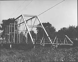 Bridge in Cumberland Township |
June 22, 1988 (#88000866) |
Legislative Route 01002 over Marsh Creek, near Greenmount 39°45′27″N 77°17′06″W |
Cumberland and Freedom Townships | |
| 5 | Carbaugh Run Rhyolite Quarry Site (36AD30) | January 15, 1986 (#86000817) |
Atop Snaggy Ridge, west of Carbaugh Run[5] 39°53′02″N 77°27′26″W |
Franklin Township | ||
| 6 | Cline's Church of the United Brethren in Christ |  Cline's Church of the United Brethren in Christ |
August 22, 2002 (#02000894) |
Cline's Church Road, 0.5 miles (0.80 km) south of Pennsylvania Route 34, near Menallen 40°00′02″N 77°13′14″W |
Menallen Township | |
| 7 | Conewago Chapel | 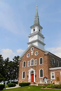 Conewago Chapel |
January 29, 1975 (#75001604) |
3 miles (4.8 km) northwest of Hanover 39°49′08″N 77°02′17″W |
Conewago Township | |
| 8 | Dobbin House | 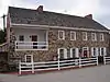 Dobbin House |
March 26, 1973 (#73001584) |
89 Steinwehr Avenue 39°49′22″N 77°13′58″W |
Gettysburg | |
| 9 | East Berlin Historic District | 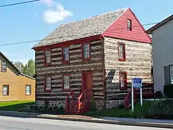 East Berlin Historic District |
September 30, 1985 (#85002693) |
Portions of King, Harrisburg, and Abbottstown Streets 39°56′17″N 76°58′56″W |
East Berlin | |
| 10 | Eisenhower National Historic Site | 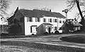 Eisenhower National Historic Site |
November 27, 1967 (#67000017) |
200 Eisenhower Farm Lane, near Gettysburg 39°47′45″N 77°16′02″W |
Cumberland Township | |
| 11 | Fairfield Historic District |  Fairfield Historic District |
May 18, 2000 (#00000518) |
Roughly bounded by Landis Drive, Steelman Street, Wortz Drive, and the northwestern borough boundary 39°47′36″N 77°22′10″W |
Fairfield | |
| 12 | Fairfield Inn |  Fairfield Inn |
April 2, 1973 (#73001583) |
Main Street 39°47′13″N 77°22′11″W |
Fairfield | |
| 13 | Gettysburg Armory | 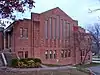 Gettysburg Armory |
April 18, 1990 (#90000422) |
315 West Confederate Avenue 39°49′37″N 77°14′38″W |
Gettysburg | |
| 14 | Gettysburg Battlefield Historic District |  Gettysburg Battlefield Historic District |
March 19, 1975 (#75000155) |
Town of Gettysburg and its environs 39°48′59″N 77°13′49″W |
Cumberland Township, Gettysburg, and Highland Township | |
| 15 | Gettysburg National Military Park | 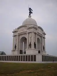 Gettysburg National Military Park |
October 15, 1966 (#66000642) |
Gettysburg National Military Park, near Gettysburg 39°48′43″N 77°14′39″W |
Cumberland, Highland, and Straban Townships | |
| 16 | Great Conewago Presbyterian Church | 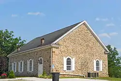 Great Conewago Presbyterian Church |
December 27, 1974 (#74001730) |
Church Road, near Hunterstown 39°53′15″N 77°09′46″W |
Straban Township | |
| 17 | Heikes Covered Bridge | 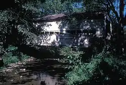 Heikes Covered Bridge |
August 25, 1980 (#80003396) |
North of Heidlersburg on Township 5857 39°58′41″N 77°08′47″W |
Huntington and Tyrone Townships | |
| 18 | Horner House and Barn | 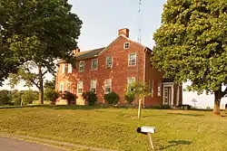 Horner House and Barn |
May 24, 2007 (#07000468) |
20 Horner Road 39°43′41″N 77°14′59″W |
Cumberland Township | |
| 19 | Hunterstown Historic District | 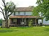 Hunterstown Historic District |
May 15, 1979 (#79002154) |
Pennsylvania Route 394 and Granite Station Road, in Hunterstown 39°53′03″N 77°09′36″W |
Straban Township | |
| 20 | Jacks Mountain Covered Bridge | 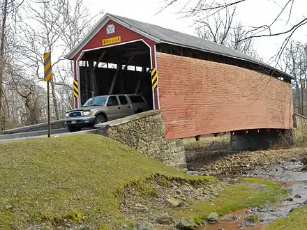 Jacks Mountain Covered Bridge |
August 25, 1980 (#80003397) |
Southwest of Fairfield on Legislative Route 01053, near Iron Springs 39°46′01″N 77°23′13″W |
Carroll Valley and Hamiltonban Township | |
| 21 | John's Burnt Mill Bridge | 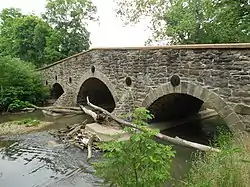 John's Burnt Mill Bridge |
December 16, 1974 (#74001731) |
Southwest of New Oxford on Township 428 39°49′56″N 77°04′47″W |
Mount Pleasant and Oxford Townships | |
| 22 | Lower Marsh Creek Presbyterian Church | 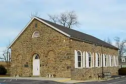 Lower Marsh Creek Presbyterian Church |
October 15, 1980 (#80003399) |
Southeast of Orrtanna on Legislative Route 01002 39°48′42″N 77°19′59″W |
Highland Township | |
| 23 | Lutheran Theological Seminary-Old Dorm | 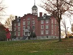 Lutheran Theological Seminary-Old Dorm |
May 3, 1974 (#74001729) |
Seminary Ridge, Lutheran Theological Seminary campus 39°49′55″N 77°14′41″W |
Gettysburg | |
| 24 | Mason and Dixon West Line Milestone Markers 76 and 77 | August 21, 2018 (#100002789) |
716 Mason Dixon Rd. 39°43′12″N 77°13′15″W |
Cumberland Township | Extends into Frederick County, Maryland | |
| 25 | Jacob and Juliana Middlekauff House | 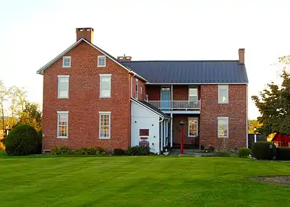 Jacob and Juliana Middlekauff House |
January 17, 2017 (#100000500) |
530 Flohrs Church Rd. 39°52′23″N 77°20′29″W |
Franklin Township | |
| 26 | Pennsylvania Hall, Gettysburg College | 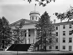 Pennsylvania Hall, Gettysburg College |
March 16, 1972 (#72001087) |
Gettysburg College campus 39°50′06″N 77°14′05″W |
Gettysburg | |
| 27 | Pleasant Grove School |  Pleasant Grove School |
September 4, 2012 (#12000603) |
4084 Baltimore Pike, Germantown 39°45′51″N 77°08′16″W |
Mount Joy Township | part of the Educational Resources of Pennsylvania Multiple Property Submission (MPS) |
| 28 | Pond Mill Bridge | 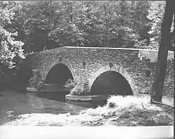 Pond Mill Bridge |
June 22, 1988 (#88000816) |
Legislative Route 01009 over Bermudian Creek, near Bermudian 39°59′45″N 77°03′31″W |
Latimore Township | |
| 29 | Rock Creek-White Run Union Hospital Complex |  Rock Creek-White Run Union Hospital Complex |
May 18, 2000 (#00000520) |
Baltimore Pike, Goulden Road, and White Church Road, near Mount Joy 39°47′20″N 77°11′59″W |
Cumberland Township, Gettysburg, and Mount Joy Township | |
| 30 | Sauck's Covered Bridge | 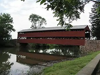 Sauck's Covered Bridge |
August 25, 1980 (#80003395) |
Waterworks Road over Marsh Creek 39°47′51″N 77°16′35″W |
Cumberland and Freedom Townships | |
| 31 | Sheads House | 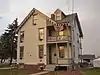 Sheads House |
December 8, 1976 (#76001592) |
331 Buford Avenue 39°50′03″N 77°14′35″W |
Gettysburg | |
| 32 | Spangler-Benner Farm | 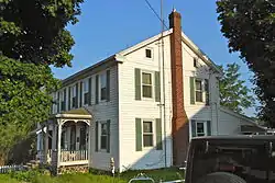 Spangler-Benner Farm |
October 29, 1992 (#92001493) |
230 Benner Road, near Gettysburg 39°44′39″N 77°13′34″W |
Mount Joy Township | |
| 33 | Thomas Brothers Store | 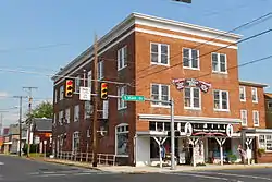 Thomas Brothers Store |
August 15, 2008 (#08000780) |
4 South Main Street 39°55′49″N 77°14′53″W |
Biglerville | |
| 34 | Wirts House | 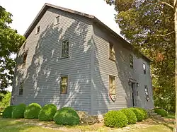 Wirts House |
January 22, 1992 (#91002010) |
798 Schrivers Corner Road (Pennsylvania Route 394), near Gettysburg 39°53′45″N 77°11′58″W |
Straban Township | |
| 35 | John Zeigler Farm House | May 7, 1992 (#92000395) |
1281 Mountain Road, near York Springs 40°02′56″N 77°07′02″W |
Latimore Township |
Former listings
| [3] | Name on the Register | Image | Date listed | Date removed | Location | Municipality | Summary |
|---|---|---|---|---|---|---|---|
| 1 | Conewago Mass House | October 19, 1978 (#78002332) | January 11, 1996 | North of McSherrystown on Pennsylvania Route 476, Conewago Township |
McSherrystown | ||
| 2 | Conewago Chapel Covered Bridge | August 26, 1980 (#80003398) | June 27, 1986 | Legislative Route 01060 |
McSherrystown |
See also
| Wikimedia Commons has media related to National Register of Historic Places in Adams County, Pennsylvania. |
References
- The latitude and longitude information provided in this table was derived originally from the National Register Information System, which has been found to be fairly accurate for about 99% of listings. Some locations in this table may have been corrected to current GPS standards.
- "National Register of Historic Places: Weekly List Actions". National Park Service, United States Department of the Interior. Retrieved on January 29, 2021.
- Numbers represent an alphabetical ordering by significant words. Various colorings, defined here, differentiate National Historic Landmarks and historic districts from other NRHP buildings, structures, sites or objects.
- The eight-digit number below each date is the number assigned to each location in the National Register Information System database, which can be viewed by clicking the number.
- Location derived from its NRHP nomination form; the NRIS lists the site as "Address Restricted"
| Topics |  | |
|---|---|---|
| Lists by county |
| |
| Lists by city | ||
| Other lists | ||
| ||
Municipalities and communities of Adams County, Pennsylvania, United States | ||
|---|---|---|
| Boroughs | | |
| Townships | ||
| CDPs | ||
| Unincorporated communities | ||
| Ghost town | ||
| ||
This article is issued from Wikipedia. The text is licensed under Creative Commons - Attribution - Sharealike. Additional terms may apply for the media files.