National Register of Historic Places listings in Clinton County, Pennsylvania
This is a list of the National Register of Historic Places listings in Clinton County, Pennsylvania.
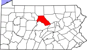
Location of Clinton County in Pennsylvania
This is intended to be a complete list of the properties and districts on the National Register of Historic Places in Clinton County, Pennsylvania, United States. The locations of National Register properties and districts for which the latitude and longitude coordinates are included below, may be seen in a map.[1]
There are 10 properties and districts listed on the National Register in the county.
- This National Park Service list is complete through NPS recent listings posted January 29, 2021.[2]
Current listings
| [3] | Name on the Register | Image | Date listed[4] | Location | City or town | Description |
|---|---|---|---|---|---|---|
| 1 | Farrandsville Iron Furnace | 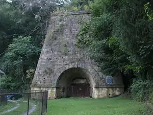 Farrandsville Iron Furnace |
September 6, 1991 (#91001137) |
Junction of Graham and Old Carrier Roads 41°10′29″N 77°30′52″W |
Colebrook Township | |
| 2 | Nathan Harvey House | 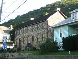 Nathan Harvey House |
January 3, 1985 (#85000034) |
425–427 South Water Street 41°06′36″N 77°29′06″W |
Mill Hall | |
| 3 | Heisey House | 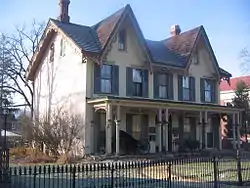 Heisey House |
March 16, 1972 (#72001113) |
362 East Water Street 41°08′15″N 77°26′24″W |
Lock Haven | |
| 4 | Logan Mills Covered Bridge | 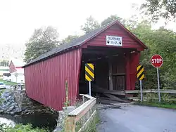 Logan Mills Covered Bridge |
August 6, 1979 (#79002213) |
Southwest of Loganton over Fishing Creek 41°00′20″N 77°23′11″W |
Logan Township | |
| 5 | Logan Mills Gristmill |  Logan Mills Gristmill |
August 11, 1980 (#80003476) |
Off Pennsylvania Route 880 41°00′23″N 77°23′01″W |
Logan Township | |
| 6 | Memorial Park Site |  Memorial Park Site |
April 14, 1982 (#82003783) |
On the southern bank of the Susquehanna River near the confluence of Bald Eagle Creek[5] 41°08′19″N 77°25′04″W |
Lock Haven | |
| 7 | Isaac A. Packer Farm | 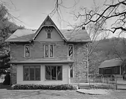 Isaac A. Packer Farm |
February 21, 1991 (#91000092) |
Farrandsville Road along the West Branch of the Susquehanna River 41°09′58″N 77°28′12″W |
Woodward Township | |
| 8 | Ravensburg State Park | 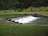 Ravensburg State Park |
May 18, 1987 (#87000741) |
8 miles (13 km) southeast of Jersey Shore on Pennsylvania Route 880 41°06′16″N 77°14′34″W |
Crawford Township | |
| 9 | Rich-McCormick Woolen Factory | 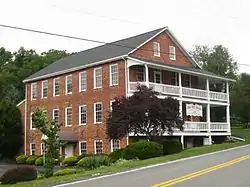 Rich-McCormick Woolen Factory |
September 5, 1985 (#85001959) |
Little Plum Run Road 41°10′17″N 77°22′16″W |
Dunnstable Township | |
| 10 | Water Street District |  Water Street District |
July 10, 1973 (#73001618) |
Roughly bounded by the Susquehanna River, St. Mary's Alley, Locust Avenue, and 6th Street 41°08′17″N 77°26′58″W |
Lock Haven |
See also
| Wikimedia Commons has media related to National Register of Historic Places in Clinton County, Pennsylvania. |
References
- The latitude and longitude information provided in this table was derived originally from the National Register Information System, which has been found to be fairly accurate for about 99% of listings. Some locations in this table may have been corrected to current GPS standards.
- "National Register of Historic Places: Weekly List Actions". National Park Service, United States Department of the Interior. Retrieved on January 29, 2021.
- Numbers represent an alphabetical ordering by significant words. Various colorings, defined here, differentiate National Historic Landmarks and historic districts from other NRHP buildings, structures, sites or objects.
- The eight-digit number below each date is the number assigned to each location in the National Register Information System database, which can be viewed by clicking the number.
- Location derived from its NRHP nomination form; the NRIS lists the site as "Address Restricted"
| Topics |  | |
|---|---|---|
| Lists by county |
| |
| Lists by city | ||
| Other lists | ||
| ||
Municipalities and communities of Clinton County, Pennsylvania, United States | ||
|---|---|---|
| City | | |
| Boroughs | ||
| Townships | ||
| CDPs | ||
| Unincorporated communities | ||
| Footnotes | ‡This populated place also has portions in an adjacent county | |
| ||
This article is issued from Wikipedia. The text is licensed under Creative Commons - Attribution - Sharealike. Additional terms may apply for the media files.