National Register of Historic Places listings in Somerset County, Pennsylvania
This is a list of the National Register of Historic Places listings in Somerset County, Pennsylvania.

Location of Somerset County in Pennsylvania
This is intended to be a complete list of the properties and districts on National Register of Historic Places in Somerset County, Pennsylvania. The locations of National Register properties and districts for which the latitude and longitude coordinates are included below, may be seen in a map.[1]
There are 32 properties and districts listed on the National Register in the county. One site is designated as a National Historic Site.
- This National Park Service list is complete through NPS recent listings posted January 29, 2021.[2]
Current listings
| [3] | Name on the Register | Image | Date listed[4] | Location | Municipality | Description |
|---|---|---|---|---|---|---|
| 1 | Barronvale Bridge | 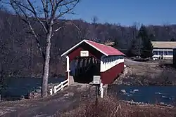 Barronvale Bridge |
December 11, 1980 (#80003633) |
West of Somerset off Legislative Route 55118 39°57′10″N 79°16′14″W |
Middlecreek Township | |
| 2 | Beechdale Bridge | 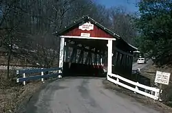 Beechdale Bridge |
December 10, 1980 (#80003628) |
Southwest of Berlin off U.S. Route 219 39°52′54″N 79°02′05″W |
Brothersvalley Township | |
| 3 | W. Bollman and Company Bridge | 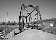 W. Bollman and Company Bridge |
November 8, 1978 (#78002471) |
Great Allegheny Passage trail over Scratch Hill Road 39°49′06″N 78°59′41″W |
Summit Township | Relocated in 2007.[5] |
| 4 | Boswell Historic District |  Boswell Historic District |
June 3, 1994 (#94000519) |
Roughly bounded by Hower Avenue, Atkinson Way, Quemahoning Creek, Main Street, and Juniata Street 40°09′47″N 79°01′40″W |
Boswell | |
| 5 | Bridge in Jenner Township | 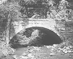 Bridge in Jenner Township |
June 22, 1988 (#88000853) |
Legislative Route 55125 over Roaring Run 40°10′18″N 79°00′49″W |
Jenner Township | |
| 6 | Cairnbrook Historic District |  Cairnbrook Historic District |
June 3, 1994 (#94000523) |
Roughly bounded by the Penn Central railroad tracks, McGregor Avenue, Windber Avenue and John Street 40°07′20″N 78°48′59″W |
Shade Township | |
| 7 | Flight 93 National Memorial | 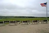 Flight 93 National Memorial |
November 8, 2002 (#04000272) |
West of Sky Line Road, Shanksville vicinity 40°03′03″N 78°54′13″W |
Stonycreek Township | |
| 8 | Fort Dewart | January 7, 2021 (#100005989) |
Address Restricted |
Allegheny Township | ||
| 9 | Glessner Bridge | 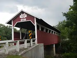 Glessner Bridge |
December 10, 1980 (#80003631) |
Northwest of Shanksville off Legislative Route 55068 40°01′33″N 78°55′16″W |
Stonycreek Township | |
| 10 | Matthew Hair Farm | 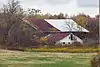 Matthew Hair Farm |
October 24, 1996 (#96001207) |
Off Pennsylvania Route 601, 1 mile (1.6 km) north of Boswell 40°11′13″N 78°59′56″W |
Jenner Township | |
| 11 | Hite House | 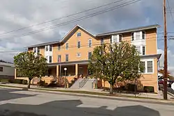 Hite House |
November 23, 1998 (#98001428) |
121 West Main Street 40°06′13″N 78°57′17″W |
Stoystown | |
| 12 | King's Bridge | 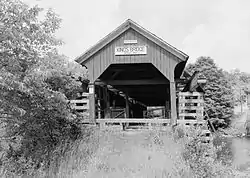 King's Bridge |
December 11, 1980 (#80003632) |
West of Somerset off Pennsylvania Route 653 39°56′15″N 79°16′17″W |
Middlecreek Township | |
| 13 | Kooser State Park Family Cabin District | 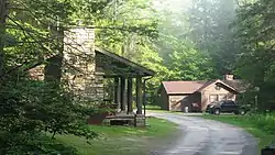 Kooser State Park Family Cabin District |
February 12, 1987 (#87000111) |
10 miles (16 km) north of Pennsylvania Turnpike Exit 10 on Pennsylvania Route 31 40°03′39″N 79°13′49″W |
Jefferson Township | |
| 14 | Laurel Hill RDA | 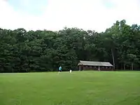 Laurel Hill RDA |
May 18, 1987 (#87000738) |
4 miles (6.4 km) west of New Centerville and Pennsylvania Route 281 39°59′55″N 79°14′12″W |
Middlecreek Township | |
| 15 | Lower Humbert Bridge |  Lower Humbert Bridge |
December 10, 1980 (#80003638) |
North of Ursina off Legislative Route 55030 39°50′24″N 79°19′23″W |
Lower Turkeyfoot Township | |
| 16 | Miller's Store | 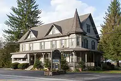 Miller's Store |
July 24, 1992 (#92000948) |
Junction of Pennsylvania Routes 3029 and 3033 39°59′11″N 79°14′28″W |
Middlecreek Township | |
| 17 | New Baltimore Bridge | 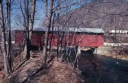 New Baltimore Bridge |
December 10, 1980 (#80003630) |
Off of Juniata Street over the Raystown Branch Juniata River 39°59′13″N 78°46′21″W |
Allegheny Township and New Baltimore | |
| 18 | New Colonial Hotel |  New Colonial Hotel |
May 10, 2005 (#05000411) |
319 Main Street 39°48′55″N 79°01′30″W |
Meyersdale | |
| 19 | Packsaddle Bridge | 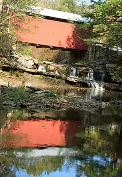 Packsaddle Bridge |
December 10, 1980 (#80003629) |
Pack Saddle Road over Brush Creek 39°52′04″N 78°49′03″W |
Fairhope Township | |
| 20 | Petersburg Tollhouse | 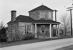 Petersburg Tollhouse |
March 20, 1979 (#79002346) |
Off U.S. Route 40 39°44′47″N 79°20′06″W |
Addison | |
| 21 | Second National Bank of Meyersdale |  Second National Bank of Meyersdale |
February 20, 2002 (#02000068) |
151 Center Street 39°48′53″N 79°01′33″W |
Meyersdale | |
| 22 | Shade Furnace Archaeological District |  Shade Furnace Archaeological District |
January 10, 2008 (#07001380) |
North of Rockingham above Dark Shade Creek[6] 40°09′11″N 78°49′42″W |
Shade Township | |
| 23 | Shaffer's Bridge | 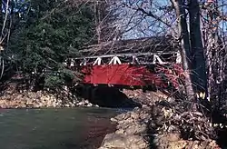 Shaffer's Bridge |
December 10, 1980 (#80003637) |
West of Tire Hill on Township 634 40°16′52″N 78°57′52″W |
Conemaugh Township | |
| 24 | Somerset County Courthouse | 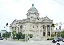 Somerset County Courthouse |
June 27, 1980 (#80003634) |
East Union Street and North Center Avenue 40°00′35″N 79°04′41″W |
Somerset | |
| 25 | Stoystown Historic District |  Stoystown Historic District |
September 7, 2001 (#01000605) |
Roughly bounded by West and East Forbes Roads, East Main Street, Meadow Street, East Penn Avenue, South Sommerset Street, West Penn Avenue and West Main Street 40°06′09″N 78°57′16″W |
Stoystown | |
| 26 | Trostletown Bridge | 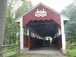 Trostletown Bridge |
December 11, 1980 (#80003636) |
Southeast of Stoystown off U.S. Route 30 40°05′45″N 78°56′44″W |
Quemahoning Township | |
| 27 | Uptown Somerset Historic District |  Uptown Somerset Historic District |
November 7, 1995 (#95001254) |
Roughly bounded by North Kimbery, Main, Columbia, and West Catherine Streets 40°00′37″N 79°04′48″W |
Somerset | |
| 28 | Wable-Augustine Tavern | 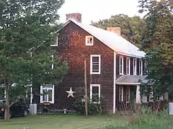 Wable-Augustine Tavern |
November 27, 1995 (#95001353) |
U.S. Route 40, approximately 1 mile (1.6 km) east of Addison 39°44′04″N 79°19′08″W |
Addison Township | |
| 29 | Walter's Mill Bridge | 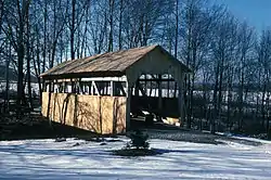 Walter's Mill Bridge |
December 10, 1980 (#80003635) |
North of Somerset off Pennsylvania Route 985 40°03′56″N 79°04′40″W |
Somerset Township | |
| 30 | Windber Historic District | 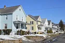 Windber Historic District |
November 14, 1991 (#91001705) |
Roughly bounded by the borough line, Cambria Avenue, 28th Street, and the Big Paint Creek 40°14′10″N 78°49′55″W |
Paint and Windber | Extends into Cambria County |
| 31 | Penrose Wolf Building | 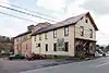 Penrose Wolf Building |
September 13, 2002 (#02000967) |
450 Main Street 39°54′50″N 79°09′28″W |
Rockwood | |
| 32 | Daniel B. Zimmerman Mansion | 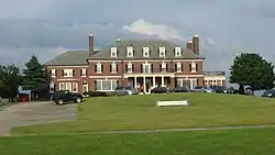 Daniel B. Zimmerman Mansion |
February 24, 1995 (#95000129) |
800 Georgian Place Drive 40°01′17″N 79°04′28″W |
Somerset Township |
See also
| Wikimedia Commons has media related to National Register of Historic Places in Somerset County, Pennsylvania. |
References
- The latitude and longitude information provided in this table was derived originally from the National Register Information System, which has been found to be fairly accurate for about 99% of listings. Some locations in this table may have been corrected to current GPS standards.
- "National Register of Historic Places: Weekly List Actions". National Park Service, United States Department of the Interior. Retrieved on January 29, 2021.
- Numbers represent an alphabetical ordering by significant words. Various colorings, defined here, differentiate National Historic Landmarks and historic districts from other NRHP buildings, structures, sites or objects.
- The eight-digit number below each date is the number assigned to each location in the National Register Information System database, which can be viewed by clicking the number.
- "The Historic Bollman Bridge". Meyersdale Area Historical Society. Archived from the original on December 2, 2013. Retrieved November 24, 2013.
- Location derived from this HAER document; the NRIS lists the site as "Address Restricted"
Municipalities and communities of Somerset County, Pennsylvania, United States | ||
|---|---|---|
| Boroughs | | |
| Townships | ||
| CDPs | ||
| Unincorporated communities | ||
| Footnotes | ‡This populated place also has portions in an adjacent county or counties | |
| ||
| Topics | 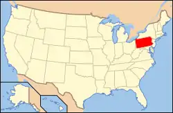 | |
|---|---|---|
| Lists by county |
| |
| Lists by city | ||
| Other lists | ||
| ||
This article is issued from Wikipedia. The text is licensed under Creative Commons - Attribution - Sharealike. Additional terms may apply for the media files.