National Register of Historic Places listings in Huntingdon County, Pennsylvania
This is a list of the National Register of Historic Places listings in Huntingdon County, Pennsylvania.
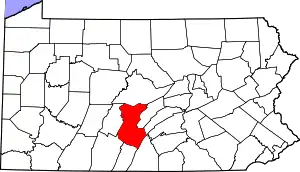
Location of Huntingdon County in Pennsylvania
This is intended to be a complete list of the properties and districts on the National Register of Historic Places in Huntingdon County, Pennsylvania, United States. The locations of National Register properties and districts for which the latitude and longitude coordinates are included below, may be seen in a map.[1]
There are 42 properties and districts listed on the National Register in the county. Two sites are further designated as National Historic Landmarks.
- This National Park Service list is complete through NPS recent listings posted January 29, 2021.[2]
Current listings
| [3] | Name on the Register | Image | Date listed[4] | Location | Municipality | Description |
|---|---|---|---|---|---|---|
| 1 | H.O. Andrews Feed Mill | 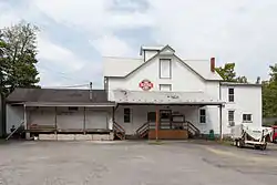 H.O. Andrews Feed Mill |
March 20, 1990 (#90000399) |
West Main Street 40°23′42″N 77°56′35″W |
Mapleton | |
| 2 | Baker Bridge | 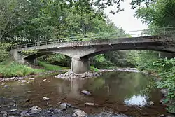 Baker Bridge |
March 20, 1990 (#90000411) |
Township Route 370 over Great Trough Creek, 1 mile (1.6 km) east of Newburg 40°17′10″N 78°07′17″W |
Todd Township | |
| 3 | Barree Forge and Furnace | 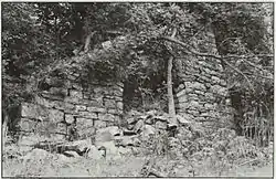 Barree Forge and Furnace |
March 20, 1990 (#90000405) |
2 miles (3.2 km) north of Alexandria along the Juniata River 40°35′18″N 78°06′04″W |
Porter Township | |
| 4 | Birmingham Bridge |  Birmingham Bridge |
March 20, 1990 (#90000400) |
Over the Juniata River, north of Birmingham off Pennsylvania Route 350 40°38′56″N 78°11′57″W |
Warriors Mark Township | Extends into Tyrone Township in Blair County |
| 5 | Brumbaugh Homestead |  Brumbaugh Homestead |
March 28, 1979 (#79002236) |
Northeast of Marklesburg off Pennsylvania Route 26 40°23′35″N 78°08′30″W |
Penn Township | |
| 6 | Colerain Forges Mansion | 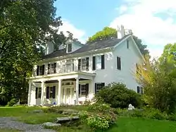 Colerain Forges Mansion |
March 20, 1990 (#90000406) |
Pennsylvania Route 45, 0.75 miles (1.21 km) south of Franklinville 40°38′20″N 78°06′00″W |
Franklin Township | |
| 7 | Corbin Bridge |  Corbin Bridge |
March 20, 1990 (#90000402) |
Township Road 428 over the Raystown Branch, southwest of Huntingdon and 0.5 miles (0.80 km) west of its confluence with the Juniata River 40°27′16″N 77°59′00″W |
Juniata Township | |
| 8 | East Broad Top Railroad |  East Broad Top Railroad |
October 15, 1966 (#66000666) |
1 mile (1.6 km) west of Orbisonia on U.S. Route 522 40°14′24″N 77°53′58″W |
Numerous municipalities[5] | Extends into Broad Top Township in Bedford County |
| 9 | Frehn Bridge | 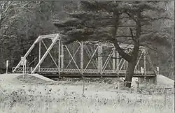 Frehn Bridge |
March 20, 1990 (#90000391) |
Township Route 313, 2 miles (3.2 km) west of Pennsylvania Route 475 40°08′00″N 77°59′29″W |
Springfield Township | The bridge has been demolished and replaced with a modern structure.[6] |
| 10 | Greenwood Furnace |  Greenwood Furnace |
November 13, 1989 (#89001819) |
Pennsylvania Route 305 in Greenwood Furnace State Park, east of McAlevys Fort 40°38′48″N 77°46′41″W |
Jackson Township | |
| 11 | Greenwood Lake Dam | 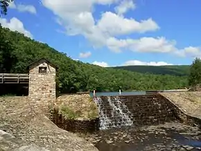 Greenwood Lake Dam |
May 11, 1987 (#87000050) |
5 miles (8.0 km) north of Belleville off Pennsylvania Route 305 40°38′55″N 77°45′32″W |
Jackson Township | |
| 12 | Harbison-Walker Refractories Company |  Harbison-Walker Refractories Company |
March 20, 1990 (#90000392) |
West Shirley Street 40°23′10″N 77°53′23″W |
Mount Union | |
| 13 | Hudson Grist Mill |  Hudson Grist Mill |
March 20, 1990 (#90000390) |
Pennsylvania Route 829 40°12′49″N 78°00′27″W |
Saltillo | |
| 14 | Huntingdon Armory | 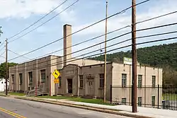 Huntingdon Armory |
December 22, 1989 (#89002075) |
Standing Stone Avenue, east of central Huntingdon 40°29′06″N 77°59′36″W |
Huntingdon | |
| 15 | Huntingdon Borough Historic District | 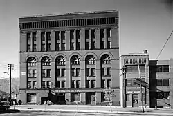 Huntingdon Borough Historic District |
April 24, 1986 (#86000852) |
Roughly bounded by Moore, Second, Allegheny, and Ninth Streets 40°29′10″N 78°00′41″W |
Huntingdon | |
| 16 | Huntingdon Furnace | 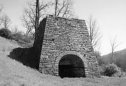 Huntingdon Furnace |
March 20, 1990 (#90000407) |
Township Road 31106 northwest of Franklinville, 2 miles (3.2 km) northwest of its junction with Pennsylvania Route 45 40°39′28″N 78°06′59″W |
Franklin Township | |
| 17 | Juniata Iron Works |  Juniata Iron Works |
March 20, 1990 (#90000404) |
Off Pennsylvania Route 885, 1.5 miles (2.4 km) east of Alexandria 40°32′40″N 78°05′00″W |
Porter Township | |
| 18 | Benjamin B. Leas House |  Benjamin B. Leas House |
February 23, 1984 (#84003401) |
U.S. Route 522 40°17′56″N 77°52′18″W |
Shirleysburg | |
| 19 | Lloyd and Henry Warehouse | 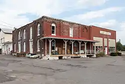 Lloyd and Henry Warehouse |
March 20, 1990 (#90000397) |
South 8th Street 40°29′11″N 78°01′05″W |
Huntingdon | |
| 20 | Marklesburg Historic District | 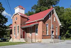 Marklesburg Historic District |
February 16, 1996 (#96000084) |
Junction of Pennsylvania Route 26 and Legislative Route 3010 40°22′57″N 78°10′22″W |
Marklesburg | |
| 21 | Minersville Coke Ovens |  Minersville Coke Ovens |
March 20, 1990 (#90000401) |
Pennsylvania Route 913, 1 mile (1.6 km) east of Coalmont 40°13′00″N 78°11′03″W |
Carbon Township | |
| 22 | Monroe Furnace |  Monroe Furnace |
November 13, 1989 (#89001818) |
Junction of Pennsylvania Route 26 and Legislative Route 31076, 6 miles (9.7 km) northwest of McAlevys Fort 40°41′43″N 77°53′41″W |
Barree Township | Only ruins are visible. Best viewed in the winter. |
| 23 | Mount Union Historic District |  Mount Union Historic District |
May 26, 1994 (#94000516) |
Roughly bounded by Water and Greene Streets, the I.O.O.F. Cemetery, and Washington and Lafayette Streets 40°23′06″N 77°53′03″W |
Mount Union | |
| 24 | Christian Oyer Jr. House | July 21, 1995 (#95000882) |
Township Road 513, northeast of Huntingdon 40°36′34″N 77°53′54″W |
Barree Township | ||
| 25 | Paradise Furnace | 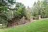 Paradise Furnace |
March 20, 1990 (#90000403) |
5 miles (8.0 km) southeast of Entriken in Trough Creek State Park 40°18′39″N 78°07′34″W |
Todd Township | |
| 26 | Pennsylvania Canal Guard Lock and Feeder Dam, Raystown Branch |  Pennsylvania Canal Guard Lock and Feeder Dam, Raystown Branch |
March 20, 1990 (#90000394) |
2.5 miles (4.0 km) east of Huntingdon, south of U.S. Route 22 on the Juniata River 40°26′59″N 77°58′09″W |
Henderson Township | |
| 27 | Pennsylvania Furnace Mansion | 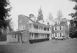 Pennsylvania Furnace Mansion |
March 20, 1990 (#90000409) |
Off Pennsylvania Route 45 at Pennsylvania Furnace, south of the Centre County line 40°42′13″N 78°00′47″W |
Franklin Township | |
| 28 | Pennsylvania Railroad Bridge over Shavers Creek | 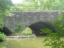 Pennsylvania Railroad Bridge over Shavers Creek |
March 20, 1990 (#90000395) |
Over Shavers Creek near its confluence with the Juniata River 40°34′01″N 78°02′54″W |
Logan Township and Petersburg | |
| 29 | Pennsylvania Railroad District | 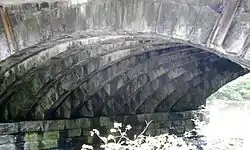 Pennsylvania Railroad District |
March 20, 1990 (#90000393) |
Conrail mile markers 213.73 to 218.88 40°36′47″N 78°09′07″W |
Spruce Creek Township | |
| 30 | Pennsylvania Railroad Old Bridge over Standing Stone Creek | 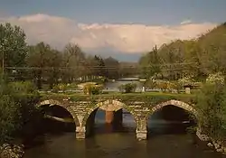 Pennsylvania Railroad Old Bridge over Standing Stone Creek |
March 20, 1990 (#90000410) |
South of Penn Street over Standing Stone Creek 40°28′51″N 78°00′17″W |
Huntingdon | |
| 31 | Pulpit Rocks | 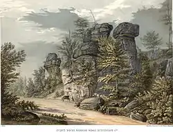 Pulpit Rocks |
November 4, 1993 (#93001614) |
Old Huntingdon-Hollidaysburg Turnpike, northwest of Huntingdon 40°31′01″N 78°02′49″W |
Porter Township | |
| 32 | Robb Farm |  Robb Farm |
April 20, 2011 (#11000202) |
11023 Hartslog Valley Road 40°29′01″N 78°05′28″W |
Walker Township | |
| 33 | Robertsdale Historic District |  Robertsdale Historic District |
May 7, 1992 (#92000391) |
Roughly bounded by the USGS 1840 contour line and South Main, Wood, Lincoln, Cliff, and Cherry Streets, in Robertsdale 40°11′01″N 78°06′45″W |
Wood Township | |
| 34 | Runk Bridge | 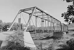 Runk Bridge |
March 20, 1990 (#90000408) |
Over Aughwick Creek, 1 mile (1.6 km) south of Shirleysburg off U.S. Route 522 40°16′40″N 77°53′14″W |
Shirley Township | |
| 35 | St. Mary's Covered Bridge |  St. Mary's Covered Bridge |
March 20, 1980 (#80003503) |
4.5 miles (7.2 km) south of Orbisonia on U.S. Route 522 40°12′21″N 77°52′42″W |
Cromwell Township | |
| 36 | Hugh D. and Martha South Seeds Farm | March 12, 1999 (#99000328) |
Legislative Route 31061, 1 mile (1.6 km) east of Pemberton 40°37′45″N 78°09′06″W |
Spruce Creek Township | ||
| 37 | Shade Gap Feed and Flour Mill |  Shade Gap Feed and Flour Mill |
March 20, 1990 (#90000396) |
U.S. Route 522, 1 mile (1.6 km) north of Shade Gap 40°11′14″N 77°52′08″W |
Dublin Township | |
| 38 | Lewis Smalley Homestead | 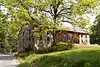 Lewis Smalley Homestead |
November 14, 1978 (#78003088) |
East of Allenport on Pennsylvania Route 103 40°21′40″N 77°49′52″W |
Shirley Township | |
| 39 | Spruce Creek Rod and Gun Club | 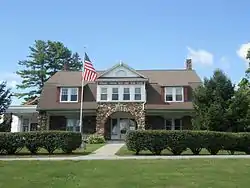 Spruce Creek Rod and Gun Club |
February 28, 1991 (#91000228) |
Pennsylvania Route 45, northeast of Franklinville (6501 Clubhouse Lane) 40°40′28″N 78°02′52″W |
Franklin Township | |
| 40 | Warrior Ridge Dam and Hydroelectric Plant | 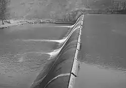 Warrior Ridge Dam and Hydroelectric Plant |
April 26, 1990 (#90000701) |
2 miles (3.2 km) south of Petersburg, along the former Conrail main line 40°32′22″N 78°02′03″W |
Logan and Porter Townships | |
| 41 | Whipple Dam State Park Day Use District | 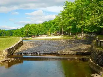 Whipple Dam State Park Day Use District |
February 12, 1987 (#87000109) |
10 miles (16 km) south of State College, east of Pennsylvania Route 26 40°41′05″N 77°51′53″W |
Jackson Township | |
| 42 | Woodvale Historic District | 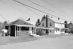 Woodvale Historic District |
July 24, 1992 (#92000942) |
Roughly bounded by Ash, High, North, Fulton, and Broad Streets in Woodvale 40°10′01″N 78°08′17″W |
Wood Township | Extends into Broad Top Township in Bedford County and Wells Township in Fulton County |
Former listing
| [3] | Name on the Register | Image | Date listed | Date removed | Location | City or town | Summary |
|---|---|---|---|---|---|---|---|
| 1 | Mount Union Refractories Company | 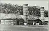 Mount Union Refractories Company |
March 20, 1990 (#90000398) | September 13, 1996 | Pennsylvania Ave. at Juniata River |
Mount Union | photo from 1991 |
See also
| Wikimedia Commons has media related to National Register of Historic Places in Huntingdon County, Pennsylvania. |
References
- The latitude and longitude information provided in this table was derived originally from the National Register Information System, which has been found to be fairly accurate for about 99% of listings. Some locations in this table may have been corrected to current GPS standards.
- "National Register of Historic Places: Weekly List Actions". National Park Service, United States Department of the Interior. Retrieved on January 29, 2021.
- Numbers represent an alphabetical ordering by significant words. Various colorings, defined here, differentiate National Historic Landmarks and historic districts from other NRHP buildings, structures, sites or objects.
- The eight-digit number below each date is the number assigned to each location in the National Register Information System database, which can be viewed by clicking the number.
- Extends through Clay Township, Cromwell Township, Mount Union, Rockville, Shirley Township, Shirleysburg, Three Springs, Todd Township, and Wood Township
- "Huntingdon County Bridge Office". Archived from the original on August 23, 2014. Retrieved September 4, 2014.
| Topics |  | |
|---|---|---|
| Lists by county |
| |
| Lists by city | ||
| Other lists | ||
| ||
Municipalities and communities of Huntingdon County, Pennsylvania, United States | ||
|---|---|---|
| Boroughs | | |
| Townships | ||
| CDPs | ||
| Unincorporated communities | ||
| Ghost town | ||
| Footnotes | ‡This populated place also has portions in an adjacent county or counties | |
| ||
This article is issued from Wikipedia. The text is licensed under Creative Commons - Attribution - Sharealike. Additional terms may apply for the media files.