National Register of Historic Places listings in Dubois County, Indiana
This is a list of the National Register of Historic Places listings in Dubois County, Indiana.
This is intended to be a complete list of the properties and districts on the National Register of Historic Places in Dubois County, Indiana, United States. Latitude and longitude coordinates are provided for many National Register properties and districts; these locations may be seen together in a map.[1]
There are 14 properties and districts listed on the National Register in the county.
Properties and districts located in incorporated areas display the name of the municipality, while properties and districts in unincorporated areas display the name of their civil township. Properties and districts split between multiple jurisdictions display the names of all jurisdictions.
- This National Park Service list is complete through NPS recent listings posted January 29, 2021.[2]
Current listings
| [3] | Name on the Register[4] | Image | Date listed[5] | Location | City or town | Description |
|---|---|---|---|---|---|---|
| 1 | Convent Immaculate Conception Historic District | 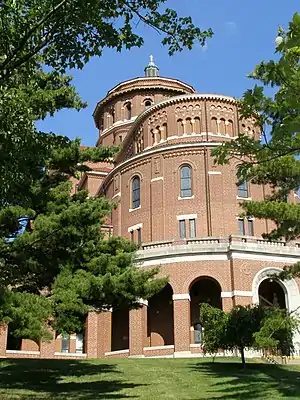 Convent Immaculate Conception Historic District |
July 13, 1983 (#83000122) |
802 E. 10th St. 38°13′23″N 86°51′08″W |
Ferdinand | |
| 2 | Dubois County Courthouse | 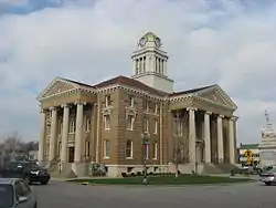 Dubois County Courthouse |
January 11, 1996 (#95001538) |
One Courthouse Square 38°23′29″N 86°55′52″W |
Jasper | |
| 3 | Evangelische Lutherische Emanuels Kirche | 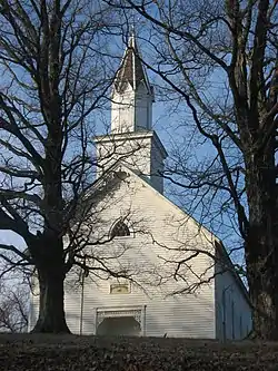 Evangelische Lutherische Emanuels Kirche |
February 23, 1990 (#90000329) |
County Road 445E, 1 mile south of State Road 56 and northwest of Dubois 38°27′59″N 86°49′23″W |
Harbison Township | |
| 4 | Gramelspacher-Gutzweiler House |  Gramelspacher-Gutzweiler House |
February 26, 1983 (#83000027) |
11th and Main Sts. 38°23′42″N 86°55′52″W |
Jasper | |
| 5 | Huntingburg Commercial Historic District | 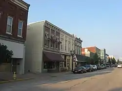 Huntingburg Commercial Historic District |
June 21, 2006 (#06000517) |
Roughly bounded by Geiger, 4th, Jackson, and Market Sts. 38°17′44″N 86°57′19″W |
Huntingburg | |
| 6 | Huntingburg Town Hall and Fire Engine House | 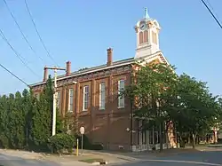 Huntingburg Town Hall and Fire Engine House |
May 12, 1975 (#75000016) |
311 Geiger St. 38°17′42″N 86°57′25″W |
Huntingburg | |
| 7 | Jasper Downtown Historic District |  Jasper Downtown Historic District |
June 12, 2017 (#100001058) |
Roughly bounded by 9th, Clay, 3rd, and Mill Sts. 38°23′29″N 86°55′51″W |
Jasper | |
| 8 | Lemmon's Church and Cemetery | 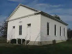 Lemmon's Church and Cemetery |
June 4, 1992 (#92000674) |
Portersville Rd. east of its junction with County Road 750W, west of Portersville 38°29′28″N 87°02′29″W |
Boone Township | |
| 9 | John Opel House |  John Opel House |
October 4, 1984 (#84000009) |
St. James St. 38°22′09″N 86°54′23″W |
Jasper | |
| 10 | St. Ferdinand Parish Historic District | 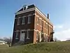 St. Ferdinand Parish Historic District |
August 31, 2020 (#100005513) |
Roughly bounded by Maryland, 8th, and 10th Sts. and St. Benedict Drive, 38°13′23″N 86°51′38″W |
Ferdinand | |
| 11 | St. Joseph Catholic Church | 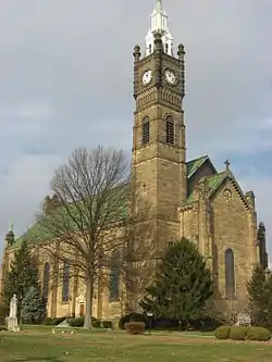 St. Joseph Catholic Church |
September 30, 1980 (#80000033) |
1215 N. Newton St. 38°23′44″N 86°55′56″W |
Jasper | |
| 12 | Shiloh Meeting House and Cemetery |  Shiloh Meeting House and Cemetery |
July 29, 1982 (#82000035) |
Southeast of Ireland on 150 North Rd. 38°23′53″N 86°58′57″W |
Madison Township | |
| 13 | Louis H. Sturm Hardware Store |  Louis H. Sturm Hardware Store |
September 28, 2003 (#03000975) |
516 Main St. 38°23′27″N 86°55′49″W |
Jasper | |
| 14 | Dr. Alois Wollenmann House | 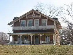 Dr. Alois Wollenmann House |
March 20, 2013 (#13000083) |
1150 Main St. 38°13′31″N 86°51′40″W |
Ferdinand |
See also
| Wikimedia Commons has media related to National Register of Historic Places in Dubois County, Indiana. |
References
- The latitude and longitude information provided in this table was derived originally from the National Register Information System, which has been found to be fairly accurate for about 99% of listings. Some locations in this table may have been corrected to current GPS standards.
- "National Register of Historic Places: Weekly List Actions". National Park Service, United States Department of the Interior. Retrieved on January 29, 2021.
- Numbers represent an alphabetical ordering by significant words. Various colorings, defined here, differentiate National Historic Landmarks and historic districts from other NRHP buildings, structures, sites or objects.
- "National Register Information System". National Register of Historic Places. National Park Service. March 13, 2009.
- The eight-digit number below each date is the number assigned to each location in the National Register Information System database, which can be viewed by clicking the number.
| Topics | |
|---|---|
| Lists by state |
|
| Lists by insular areas | |
| Lists by associated state | |
| Other areas | |
| Related | |
| |
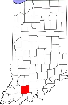
Municipalities and communities of Dubois County, Indiana, United States | ||
|---|---|---|
| Cities | Map of Indiana highlighting Dubois County | |
| Towns | ||
| Townships | ||
| CDP | ||
| Other unincorporated communities | ||
| Ghost town | ||
| Footnotes | ‡This populated place also has portions in an adjacent county or counties | |
| ||