National Register of Historic Places listings in Jefferson County, Indiana
This is a list of the National Register of Historic Places listings in Jefferson County, Indiana.
This is intended to be a complete list of the properties and districts on the National Register of Historic Places in Jefferson County, Indiana, United States. Latitude and longitude coordinates are provided for many National Register properties and districts; these locations may be seen together in a map.[1]
There are 13 properties and districts listed on the National Register in the county, including 4 National Historic Landmarks.
Properties and districts located in incorporated areas display the name of the municipality, while properties and districts in unincorporated areas display the name of their civil township. Properties and districts split between multiple jurisdictions display the names of all jurisdictions.
- This National Park Service list is complete through NPS recent listings posted February 5, 2021.[2]
Current listings
| [3] | Name on the Register[4] | Image | Date listed[5] | Location | City or town | Description |
|---|---|---|---|---|---|---|
| 1 | Lemuel Allen Farm | 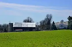 Lemuel Allen Farm |
June 7, 2016 (#16000334) |
3768 E. Pleasant Ridge Rd. 38°45′32″N 85°19′04″W |
Madison Township | |
| 2 | Crawford-Whitehead-Ross House | 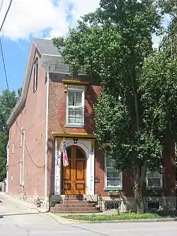 Crawford-Whitehead-Ross House |
November 27, 1992 (#92001648) |
510 W. Main St. 38°44′15″N 85°23′06″W |
Madison | |
| 3 | Crowe-Garritt House | 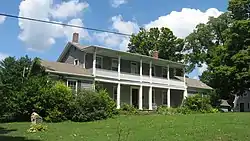 Crowe-Garritt House |
November 10, 1980 (#80000041) |
172 Crowe St. 38°42′55″N 85°28′16″W |
Hanover | |
| 4 | Eleutherian College | 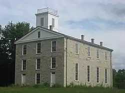 Eleutherian College |
December 15, 1993 (#93001410) |
State Road 250 at Lancaster 38°49′51″N 85°30′59″W |
Lancaster Township | |
| 5 | Thomas A. Hendricks Library |  Thomas A. Hendricks Library |
February 26, 1982 (#82000043) |
College Dr. (Campus Rd.) east of Hanover 38°42′45″N 85°27′28″W |
Hanover Township | |
| 6 | Lyman and Asenath Hoyt House | 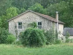 Lyman and Asenath Hoyt House |
September 28, 2003 (#03000977) |
7147 W. State Road 250 at Lancaster 38°49′56″N 85°31′14″W |
Lancaster Township | |
| 7 | Jefferson County Jail | .jpg.webp) Jefferson County Jail |
June 18, 1973 (#73000019) |
Courthouse Square 38°44′09″N 85°22′35″W |
Madison | |
| 8 | Lanier Mansion |  Lanier Mansion |
April 19, 1994 (#94001191) |
511 W. 1st St. 38°44′07″N 85°23′10″W |
Madison | |
| 9 | Madison Historic District | 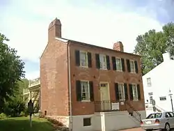 Madison Historic District |
May 25, 1973 (#73000020) |
Roughly bounded by Crooked Creek, Springdale Cemetery, Michigan, New Hill and Telegraph Hill Rds., and the Ohio River 38°44′10″N 85°22′48″W |
Madison | |
| 10 | Oakdale School | May 14, 1993 (#93000432) |
Morgan Rd., Jefferson Proving Ground 38°50′24″N 85°25′33″W |
Monroe Township | ||
| 11 | St. Stephen's African Methodist Episcopal Church | 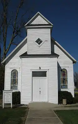 St. Stephen's African Methodist Episcopal Church |
December 28, 2000 (#00001544) |
220 W. Main St. 38°42′53″N 85°28′38″W |
Hanover | |
| 12 | Charles L. Shrewsbury House | .jpg.webp) Charles L. Shrewsbury House |
April 19, 1994 (#94001190) |
301 W. 1st St. 38°44′05″N 85°22′58″W |
Madison | |
| 13 | Mathias Wolf Farm | 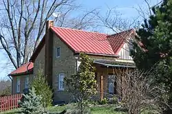 Mathias Wolf Farm |
June 7, 2016 (#16000335) |
4137 E. Pleasant Ridge Rd. 38°45′45″N 85°18′38″W |
Madison Township |
See also
| Wikimedia Commons has media related to National Register of Historic Places in Jefferson County, Indiana. |
References
- The latitude and longitude information provided in this table was derived originally from the National Register Information System, which has been found to be fairly accurate for about 99% of listings. Some locations in this table may have been corrected to current GPS standards.
- "National Register of Historic Places: Weekly List Actions". National Park Service, United States Department of the Interior. Retrieved on February 5, 2021.
- Numbers represent an alphabetical ordering by significant words. Various colorings, defined here, differentiate National Historic Landmarks and historic districts from other NRHP buildings, structures, sites or objects.
- "National Register Information System". National Register of Historic Places. National Park Service. March 13, 2009.
- The eight-digit number below each date is the number assigned to each location in the National Register Information System database, which can be viewed by clicking the number.
| Topics | |
|---|---|
| Lists by state |
|
| Lists by insular areas | |
| Lists by associated state | |
| Other areas | |
| Related | |
| |
Municipalities and communities of Jefferson County, Indiana, United States | ||
|---|---|---|
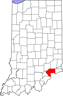
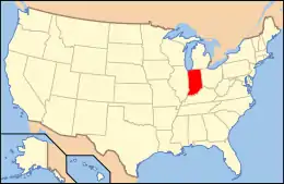
| City | Map of Indiana highlighting Jefferson County | |
| Towns | ||
| Townships | ||
| CDPs | ||
| Other unincorporated communities | ||
| Footnotes | ‡This populated place also has portions in an adjacent county or counties | |
| ||