National Register of Historic Places listings in Hancock County, Indiana
This is a list of the National Register of Historic Places listings in Hancock County, Indiana.
This is intended to be a complete list of the properties and districts on the National Register of Historic Places in Hancock County, Indiana, United States. Latitude and longitude coordinates are provided for many National Register properties and districts; these locations may be seen together in a map.[1]
There are 12 properties and districts listed on the National Register in the county. Another 2 properties were once listed but have been removed.
Properties and districts located in incorporated areas display the name of the municipality, while properties and districts in unincorporated areas display the name of their civil township. Properties and districts split between multiple jurisdictions display the names of all jurisdictions.
- This National Park Service list is complete through NPS recent listings posted February 5, 2021.[2]
Current listings
| [3] | Name on the Register[4] | Image | Date listed[5] | Location | City or town | Description |
|---|---|---|---|---|---|---|
| 1 | Charles Barr House | 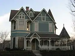 Charles Barr House |
December 22, 2008 (#08001208) |
25 W. Walnut St. 39°47′14″N 85°46′12″W |
Greenfield | |
| 2 | Rufus and Amanda Black House | 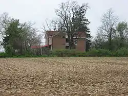 Rufus and Amanda Black House |
September 30, 2014 (#14000802) |
222 S200W at Philadelphia 39°46′45″N 85°50′29″W |
Sugar Creek Township | |
| 3 | Browne-Rafert House | 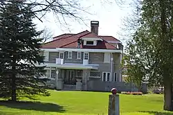 Browne-Rafert House |
September 14, 2015 (#15000595) |
534 N. Merrill St., near Fortville 39°56′21″N 85°51′15″W |
Vernon Township | |
| 4 | County Line Bridge |  County Line Bridge |
November 25, 1994 (#94001356) |
County Road 900E over the Big Blue River, northeast of Morristown 39°42′35″N 85°37′59″W |
Blue River Township | Extends into Rush County |
| 5 | Greenfield Courthouse Square Historic District |  Greenfield Courthouse Square Historic District |
March 7, 1985 (#85000455) |
Roughly bounded by North, Hinchman, South, and Pennsylvania Sts. 39°47′07″N 85°46′10″W |
Greenfield | |
| 6 | Greenfield Residential Historic District | 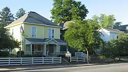 Greenfield Residential Historic District |
December 15, 2011 (#11000909) |
Roughly bounded by Hendricks, South, and Wood Sts., and Boyd Ave. 39°47′07″N 85°46′23″W |
Greenfield | |
| 7 | Lilly Biological Laboratories | 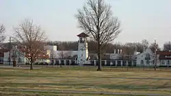 Lilly Biological Laboratories |
November 23, 1977 (#77000016) |
West of Greenfield off U.S. Route 40 39°46′51″N 85°47′51″W |
Greenfield | |
| 8 | Lincoln Park School | 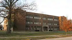 Lincoln Park School |
June 17, 2009 (#09000424) |
600 W. North St. 39°47′09″N 85°46′37″W |
Greenfield | |
| 9 | Frank Littleton Round Barn | 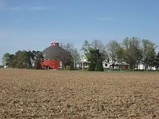 Frank Littleton Round Barn |
April 2, 1993 (#93000184) |
Near the junction of County Roads 600N and 500W, northeast of Mount Comfort[6] 39°52′22″N 85°53′25″W |
Vernon Township | |
| 10 | Lockheed PV-2 Harpoon No. 37396 |  Lockheed PV-2 Harpoon No. 37396 |
May 1, 2009 (#09000234) |
3867 N. Aviation Way at the Indianapolis Regional Airport 39°50′37″N 85°54′12″W |
Buck Creek Township | |
| 11 | Jane Ross Reeves Octagon House |  Jane Ross Reeves Octagon House |
September 16, 2001 (#01000620) |
400 S. Railroad St. 39°53′32″N 85°34′45″W |
Shirley | |
| 12 | James Whitcomb Riley House | 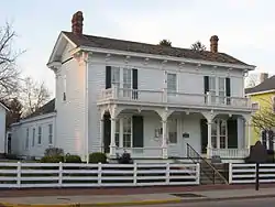 James Whitcomb Riley House |
September 28, 1977 (#77000017) |
250 W. Main St. 39°47′06″N 85°46′24″W |
Greenfield |
Former listings
| [3] | Name on the Register | Image | Date listed | Date removed | Location | City or town | Summary |
|---|---|---|---|---|---|---|---|
| 1 | Greenfield High School | April 22, 1982 (#82000039) | June 18, 1986 | North and Pennsylvania Sts. |
Greenfield | ||
| 2 | New Palestine School | June 14, 1991 (#91000791) | March 17, 1992 | Larrabee St. at jct. with Depot St. |
New Palestine |
See also
| Wikimedia Commons has media related to National Register of Historic Places in Hancock County, Indiana. |
References
- The latitude and longitude information provided in this table was derived originally from the National Register Information System, which has been found to be fairly accurate for about 99% of listings. Some locations in this table may have been corrected to current GPS standards.
- "National Register of Historic Places: Weekly List Actions". National Park Service, United States Department of the Interior. Retrieved on February 5, 2021.
- Numbers represent an alphabetical ordering by significant words. Various colorings, defined here, differentiate National Historic Landmarks and historic districts from other NRHP buildings, structures, sites or objects.
- "National Register Information System". National Register of Historic Places. National Park Service. March 13, 2009.
- The eight-digit number below each date is the number assigned to each location in the National Register Information System database, which can be viewed by clicking the number.
- Location derived from Division of Historic Preservation and Archaeology. Hancock County Interim Report. Indianapolis: Indiana Department of Natural Resources, 1983-06, 12-13. The NRIS lists the site as "Address Restricted".
| Topics | |
|---|---|
| Lists by state |
|
| Lists by insular areas | |
| Lists by associated state | |
| Other areas | |
| Related | |
| |
Municipalities and communities of Hancock County, Indiana, United States | ||
|---|---|---|
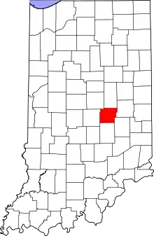
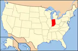
| City | Map of Indiana highlighting Hancock County | |
| Towns | ||
| Townships | ||
| Unincorporated communities | ||
| Footnotes | ‡This populated place also has portions in an adjacent county or counties | |
| ||