National Register of Historic Places listings in Shelby County, Indiana
This is a list of the National Register of Historic Places listings in Shelby County, Indiana.
This is intended to be a complete list of the properties and districts on the National Register of Historic Places in Shelby County, Indiana, United States. Latitude and longitude coordinates are provided for many National Register properties and districts; these locations may be seen together in a map.[1]
There are 13 properties and districts listed on the National Register in the county.
Properties and districts located in incorporated areas display the name of the municipality, while properties and districts in unincorporated areas display the name of their civil township. Properties and districts split between multiple jurisdictions display the names of all jurisdictions.
- This National Park Service list is complete through NPS recent listings posted January 29, 2021.[2]
Current listings
| [3] | Name on the Register[4] | Image | Date listed[5] | Location | City or town | Description |
|---|---|---|---|---|---|---|
| 1 | Cooper-Alley House | 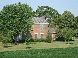 Cooper-Alley House |
July 7, 1982 (#82000074) |
South of Waldron 39°25′15″N 85°40′23″W |
Noble Township | |
| 2 | John Hamilton House |  John Hamilton House |
June 4, 1979 (#79000043) |
132 W. Washington St. 39°31′28″N 85°46′48″W |
Shelbyville | |
| 3 | Junction Railroad Depot | 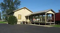 Junction Railroad Depot |
November 14, 1979 (#79000044) |
U.S. Route 52 39°40′29″N 85°42′17″W |
Morristown | |
| 4 | Liberty Township Schoolhouse No. 2 | 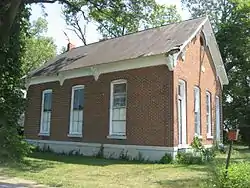 Liberty Township Schoolhouse No. 2 |
September 4, 1992 (#92001170) |
Junction of State Road 244 and County Road 600E, north of Waldron 39°29′51″N 85°40′03″W |
Liberty Township | |
| 5 | Middletown Bridge |  Middletown Bridge |
December 24, 2009 (#09001135) |
County Road 450S over Conn's Creek, northwest of Middletown 39°27′44″N 85°39′06″W |
Liberty Township | |
| 6 | Lora B. Pearson School |  Lora B. Pearson School |
December 24, 2009 (#09001136) |
115 W. Colescott St. 39°31′04″N 85°46′43″W |
Shelbyville | |
| 7 | Porter Pool Bathhouse |  Porter Pool Bathhouse |
December 7, 2001 (#01001348) |
501 N. Harrison St. 39°31′41″N 85°46′40″W |
Shelbyville | |
| 8 | George Rudicel Polygonal Barn |  George Rudicel Polygonal Barn |
May 27, 1993 (#93000463) |
Junction of County Roads 700S and 400E, southwest of Waldron 39°25′27″N 85°42′12″W |
Noble Township | |
| 9 | St. George Lutheran Church | 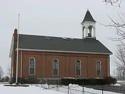 St. George Lutheran Church |
May 24, 1984 (#84001627) |
State Road 252, east of Edinburgh 39°21′51″N 85°53′41″W |
Jackson Township | |
| 10 | Shelbyville Commercial Historic District | 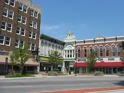 Shelbyville Commercial Historic District |
August 9, 1984 (#84001638) |
Roughly bounded by Broadway, Tompkins, Mechanic, and Noble Sts. 39°31′27″N 85°46′33″W |
Shelbyville | |
| 11 | Shelby County Courthouse | 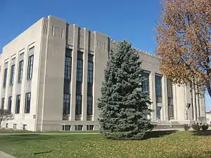 Shelby County Courthouse |
December 15, 2011 (#11000917) |
407 S. Harrison St. 39°31′16″N 85°46′40″W |
Shelbyville | |
| 12 | Shelbyville High School |  Shelbyville High School |
January 11, 1996 (#95001535) |
Junction of 2nd and Tompkins Sts. 39°30′54″N 85°46′47″W |
Shelbyville | |
| 13 | West Side Historic District | 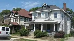 West Side Historic District |
February 9, 1990 (#90000099) |
Roughly bounded by W. Pennsylvania, N. Harrison, N. and S. Thompkins, W. Hendricks, Montgomery, and N. Conrey 39°31′31″N 85°46′54″W |
Shelbyville |
See also
| Wikimedia Commons has media related to National Register of Historic Places in Shelby County, Indiana. |
References
- The latitude and longitude information provided in this table was derived originally from the National Register Information System, which has been found to be fairly accurate for about 99% of listings. Some locations in this table may have been corrected to current GPS standards.
- "National Register of Historic Places: Weekly List Actions". National Park Service, United States Department of the Interior. Retrieved on January 29, 2021.
- Numbers represent an alphabetical ordering by significant words. Various colorings, defined here, differentiate National Historic Landmarks and historic districts from other NRHP buildings, structures, sites or objects.
- "National Register Information System". National Register of Historic Places. National Park Service. March 13, 2009.
- The eight-digit number below each date is the number assigned to each location in the National Register Information System database, which can be viewed by clicking the number.
| Topics | |
|---|---|
| Lists by state |
|
| Lists by insular areas | |
| Lists by associated state | |
| Other areas | |
| Related | |
| |
Municipalities and communities of Shelby County, Indiana, United States | ||
|---|---|---|
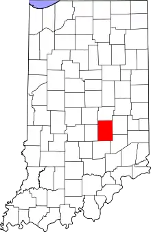
| City | Map of Indiana highlighting Shelby County | |
| Towns | ||
| Townships | ||
| CDP | ||
| Other unincorporated communities |
| |
| Footnotes | ‡This populated place also has portions in an adjacent county or counties | |
| ||