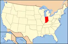
National Register of Historic Places listings in Noble County, Indiana
This is a list of the National Register of Historic Places listings in Noble County, Indiana.
This is intended to be a complete list of the properties and districts on the National Register of Historic Places in Noble County, Indiana, United States. Latitude and longitude coordinates are provided for many National Register properties and districts; these locations may be seen together in a map.[1]
There are 16 properties and districts listed on the National Register in the county.
Properties and districts located in incorporated areas display the name of the municipality, while properties and districts in unincorporated areas display the name of their civil township. Properties and districts split between multiple jurisdictions display the names of all jurisdictions.
- This National Park Service list is complete through NPS recent listings posted February 5, 2021.[2]
Current listings
| [3] | Name on the Register[4] | Image | Date listed[5] | Location | City or town | Description |
|---|---|---|---|---|---|---|
| 1 | Ahavas Shalom Reform Temple |  Ahavas Shalom Reform Temple |
June 16, 1983 (#83000143) |
503 S. Main St. 41°27′42″N 85°35′20″W |
Ligonier | |
| 2 | Albion Courthouse Square Historic District |  Albion Courthouse Square Historic District |
December 31, 2013 (#13001014) |
Roughly bounded by Highland, Oak, and Hazel Sts., and the alley east of Orange St. 41°23′48″N 85°25′28″W |
Albion | |
| 3 | Brimfield School No. 2 | March 11, 2019 (#100003504) |
N 140 E, 1 blk. N. of E. 3rd St. 41°27′23″N 85°23′52″W |
Brimfield vicinity | ||
| 4 | Cromwell Historic District | 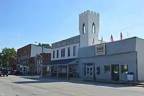 Cromwell Historic District |
September 14, 2015 (#15000597) |
Jefferson between 2nd & Orange Sts. 41°24′04″N 85°36′54″W |
Cromwell | |
| 5 | Iddings-Gilbert-Leader-Anderson Block | 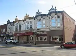 Iddings-Gilbert-Leader-Anderson Block |
July 21, 1987 (#87000544) |
105-113 N. Main St. 41°26′39″N 85°15′58″W |
Kendallville | |
| 6 | Jefferson Union Church and Sweet Cemetery | 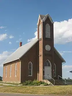 Jefferson Union Church and Sweet Cemetery |
March 24, 2010 (#10000126) |
3015 E415N, east of Albion 41°24′44″N 85°22′01″W |
Jefferson Township | |
| 7 | Kendallville Downtown Historic District | 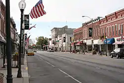 Kendallville Downtown Historic District |
December 23, 2003 (#03001315) |
Roughly bounded by Harris and Rush Sts. and the alleys east and west of Main 41°26′35″N 85°15′55″W |
Kendallville | |
| 8 | Kneipp Springs Historic District | March 6, 2018 (#100002183) |
2725 and 2730 E. Northport Rd. 41°30′17″N 85°22′20″W |
Orange Township | ||
| 9 | Ligonier Historic District | 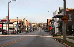 Ligonier Historic District |
October 23, 1987 (#87001798) |
Roughly bounded by the former Conrail right-of-way and Smith, Union, College, and Grand Sts. 41°27′46″N 85°35′23″W |
Ligonier | |
| 10 | Luckey Hospital |  Luckey Hospital |
March 20, 2013 (#13000090) |
Junction of U.S. Route 33 and State Road 109 at Wolf Lake 41°20′00″N 85°29′39″W |
Noble Township | |
| 11 | Noble County Courthouse | 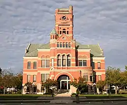 Noble County Courthouse |
May 12, 1981 (#81000005) |
Courthouse Square 41°23′45″N 85°25′28″W |
Albion | |
| 12 | Noble County Sheriff's House and Jail |  Noble County Sheriff's House and Jail |
December 27, 1982 (#82000026) |
W. Main and Oak Sts. 41°23′44″N 85°25′34″W |
Albion | |
| 13 | Stanley School-District No. 2 | 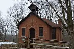 Stanley School-District No. 2 |
December 16, 2014 (#14001038) |
S300E south of Albion 41°20′17″N 85°21′57″W |
Green Township | |
| 14 | Gene Stratton-Porter Cabin | 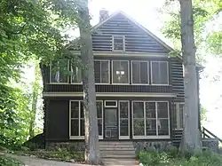 Gene Stratton-Porter Cabin |
June 27, 1974 (#74000015) |
Southeast of Rome City off State Road 9 41°28′51″N 85°20′55″W |
Orange Township | |
| 15 | Stone's Trace | 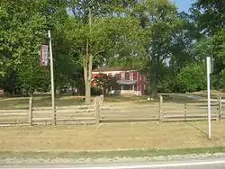 Stone's Trace |
May 24, 1984 (#84001212) |
U.S. Route 33 and State Road 5, south of Ligonier 41°25′35″N 85°35′10″W |
Sparta Township | |
| 16 | Jacob Straus House | 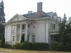 Jacob Straus House |
June 4, 1979 (#79000011) |
210 S. Main St. 41°27′50″N 85°35′22″W |
Ligonier |
See also
| Wikimedia Commons has media related to National Register of Historic Places in Noble County, Indiana. |
References
- The latitude and longitude information provided in this table was derived originally from the National Register Information System, which has been found to be fairly accurate for about 99% of listings. Some locations in this table may have been corrected to current GPS standards.
- "National Register of Historic Places: Weekly List Actions". National Park Service, United States Department of the Interior. Retrieved on February 5, 2021.
- Numbers represent an alphabetical ordering by significant words. Various colorings, defined here, differentiate National Historic Landmarks and historic districts from other NRHP buildings, structures, sites or objects.
- "National Register Information System". National Register of Historic Places. National Park Service. March 13, 2009.
- The eight-digit number below each date is the number assigned to each location in the National Register Information System database, which can be viewed by clicking the number.
| Topics | |
|---|---|
| Lists by state |
|
| Lists by insular areas | |
| Lists by associated state | |
| Other areas | |
| Related | |
| |
Municipalities and communities of Noble County, Indiana, United States | ||
|---|---|---|
| Cities | Map of Indiana highlighting Noble County | |
| Towns | ||
| Townships | ||
| CDP | ||
| Unincorporated communities | ||
| Footnotes | ‡This populated place also has portions in an adjacent county or counties | |
| ||