National Register of Historic Places listings in Franklin County, Indiana
This is a list of the National Register of Historic Places listings in Franklin County, Indiana.
This is intended to be a complete list of the properties and districts on the National Register of Historic Places in Franklin County, Indiana, United States. Latitude and longitude coordinates are provided for many National Register properties and districts; these locations may be seen together in a map.[1]
There are 14 properties and districts listed on the National Register in the county, including 1 National Historic Landmark.
Properties and districts located in incorporated areas display the name of the municipality, while properties and districts in unincorporated areas display the name of their civil township. Properties and districts split between multiple jurisdictions display the names of all jurisdictions.
- This National Park Service list is complete through NPS recent listings posted February 5, 2021.[2]
Current listings
| [3] | Name on the Register[4] | Image | Date listed[5] | Location | City or town | Description |
|---|---|---|---|---|---|---|
| 1 | Brookville Historic District | 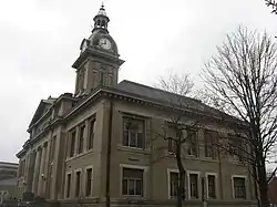 Brookville Historic District |
July 25, 1975 (#75000018) |
Bounded by the east and west forks of the Whitewater River and State Road 101 39°25′22″N 85°00′35″W |
Brookville | |
| 2 | Cedar Grove Bridge | 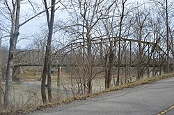 Cedar Grove Bridge |
September 30, 2014 (#14000801) |
Old State Road 1 over the Whitewater River 39°21′12″N 84°56′35″W |
Cedar Grove and Highland Township | |
| 3 | Duck Creek Aqueduct | 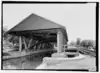 Duck Creek Aqueduct |
August 25, 2014 (#14000922) |
Spanning Duck Creek at the Whitewater Canal 39°26′46″N 85°07′48″W |
Metamora Township | |
| 4 | Franklin County Seminary | 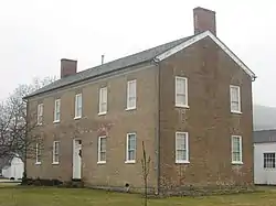 Franklin County Seminary |
March 28, 1974 (#74000020) |
412 5th St. 39°25′10″N 85°00′31″W |
Brookville | |
| 5 | The Hermitage | 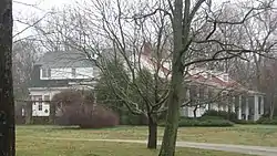 The Hermitage |
March 22, 2004 (#04000209) |
650 E. 8th St. 39°25′25″N 85°00′17″W |
Brookville | |
| 6 | Little Cedar Grove Baptist Church | 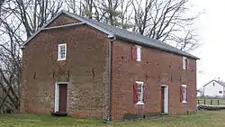 Little Cedar Grove Baptist Church |
March 22, 1990 (#90000366) |
U.S. Route 52 at Little Cedar Rd., southeast of Brookville 39°23′14″N 84°58′53″W |
Brookville Township | |
| 7 | Metamora Historic District |  Metamora Historic District |
December 7, 1992 (#92001646) |
Roughly bounded by U.S. Route 52, Columbia St., the Whitewater Canal, Duck Creek, Mount St., and Main St., at Metamora 39°26′49″N 85°08′01″W |
Metamora | |
| 8 | Oldenburg Historic District | 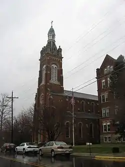 Oldenburg Historic District |
March 3, 1983 (#83000031) |
Bounded roughly by Sycamore, church land woods, Indiana and Water Sts., and Gehring Farm 39°20′27″N 85°12′09″W |
Oldenburg and Ray Township | |
| 9 | Old Franklin United Brethren Church |  Old Franklin United Brethren Church |
March 3, 1995 (#95000201) |
Junction of Franklin Church Rd. and State Road 101, 0.5 miles north of Fox Run Rd. and northeast of Brookville 39°30′22″N 84°56′56″W |
Fairfield Township | |
| 10 | Joseph Shafer Farm | 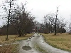 Joseph Shafer Farm |
August 26, 1982 (#82000038) |
Northeast of Brookville on Flinn Road 39°28′26″N 84°52′46″W |
Springfield Township | |
| 11 | Snow Hill Covered Bridge |  Snow Hill Covered Bridge |
March 3, 1995 (#95000208) |
Snow Hill Rd. over Johnson Fork, north of Rockdale 39°19′32″N 84°51′06″W |
Whitewater Township | |
| 12 | Stockheughter Covered Bridge | 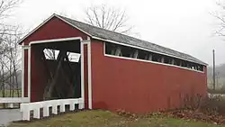 Stockheughter Covered Bridge |
March 20, 2002 (#02000198) |
27046 Enochsburg Rd., northwest of Batesville 39°20′01″N 85°16′52″W |
Ray Township | |
| 13 | Salmon Turrell Farmstead | 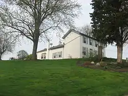 Salmon Turrell Farmstead |
June 17, 2009 (#09000423) |
3051 Snow Hill Rd., northwest of West Harrison 39°19′40″N 84°51′37″W |
Whitewater Township | |
| 14 | Whitewater Canal Historic District |  Whitewater Canal Historic District |
June 13, 1973 (#73000272) |
From the Laurel Feeder Dam to Brookville 39°27′33″N 85°06′34″W |
Brookville and Brookville, Laurel, and Metamora Townships |
See also
| Wikimedia Commons has media related to National Register of Historic Places in Franklin County, Indiana. |
References
- The latitude and longitude information provided in this table was derived originally from the National Register Information System, which has been found to be fairly accurate for about 99% of listings. Some locations in this table may have been corrected to current GPS standards.
- "National Register of Historic Places: Weekly List Actions". National Park Service, United States Department of the Interior. Retrieved on February 5, 2021.
- Numbers represent an alphabetical ordering by significant words. Various colorings, defined here, differentiate National Historic Landmarks and historic districts from other NRHP buildings, structures, sites or objects.
- "National Register Information System". National Register of Historic Places. National Park Service. March 13, 2009.
- The eight-digit number below each date is the number assigned to each location in the National Register Information System database, which can be viewed by clicking the number.
| Topics | |
|---|---|
| Lists by state |
|
| Lists by insular areas | |
| Lists by associated state | |
| Other areas | |
| Related | |
| |
Municipalities and communities of Franklin County, Indiana, United States | ||
|---|---|---|
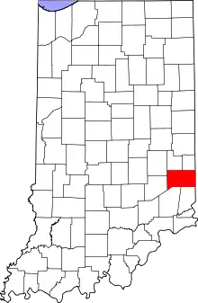
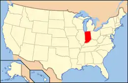
| City | Map of Indiana highlighting Franklin County | |
| Towns | ||
| Townships | ||
| CDPs | ||
| Other unincorporated communities |
| |
| Footnotes | ‡This populated place also has portions in an adjacent county or counties | |
| ||