National Register of Historic Places listings in Miami County, Indiana
This is a list of the National Register of Historic Places listings in Miami County, Indiana.
This is intended to be a complete list of the properties on the National Register of Historic Places in Miami County, Indiana, United States. Latitude and longitude coordinates are provided for many National Register properties; these locations may be seen together in a map.[1]
There are 15 properties listed on the National Register in the county, including 1 National Historic Landmark. One property was listed, but has since been removed.
Properties and districts located in incorporated areas display the name of the municipality, while properties and districts in unincorporated areas display the name of their civil township. Properties and districts split between multiple jurisdictions display the names of all jurisdictions.
- This National Park Service list is complete through NPS recent listings posted January 29, 2021.[2]
Current listings
| [3] | Name on the Register[4] | Image | Date listed[5] | Location | City or town | Description |
|---|---|---|---|---|---|---|
| 1 | B-17G "Flying Fortress" No. 44-83690 | 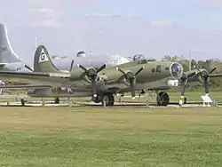 B-17G "Flying Fortress" No. 44-83690 |
June 29, 1993 (#93000540) |
Heritage Museum Foundation, off U.S. Route 31 at Grissom Air Force Base 40°40′06″N 86°07′46″W |
Pipe Creek Township | |
| 2 | Brownell Block/Senger Dry Goods Company Building | 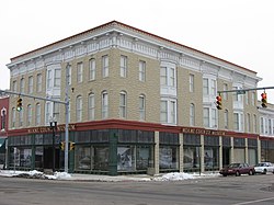 Brownell Block/Senger Dry Goods Company Building |
September 1, 1983 (#83000007) |
Broadway and 5th Sts. 40°45′18″N 86°04′10″W |
Peru | |
| 3 | James Omar Cole House |  James Omar Cole House |
March 1, 1984 (#84001198) |
27 E. 3rd St. 40°45′12″N 86°04′00″W |
Peru | |
| 4 | Converse Commercial Historic District | 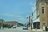 Converse Commercial Historic District |
December 27, 2016 (#16000907) |
4 blocks along Jefferson between Marion and 1st Sts., and 1 block of E. Railroad St. 40°34′45″N 85°52′24″W |
Converse | |
| 5 | Converse Depot | 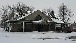 Converse Depot |
March 3, 1995 (#95000205) |
203 E. Railroad St. 40°34′49″N 85°52′14″W |
Converse | |
| 6 | Converse-Jackson Township Public Library |  Converse-Jackson Township Public Library |
March 12, 1999 (#99000298) |
100 S. Jefferson St. 40°34′39″N 85°52′26″W |
Converse | |
| 7 | Eikenberry Bridge | 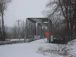 Eikenberry Bridge |
September 20, 2006 (#06000848) |
County Road 100E over the Eel River, southwest of Chili 40°51′19″N 86°03′21″W |
Richland Township | |
| 8 | Francis Godfroy Cemetery | 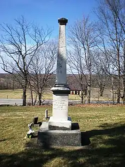 Francis Godfroy Cemetery |
March 1, 1984 (#84001203) |
State Road 124, east of Peru 40°45′03″N 85°59′35″W |
Butler Township | |
| 9 | Terrell Jacobs Circus Winter Quarters | 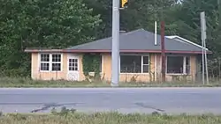 Terrell Jacobs Circus Winter Quarters |
April 5, 2012 (#12000188) |
6125 U.S. Route 31, south of Peru 40°40′36″N 86°07′38″W |
Pipe Creek Township | |
| 10 | Miami County Courthouse |  Miami County Courthouse |
March 19, 2008 (#08000194) |
Public Square 40°45′16″N 86°04′08″W |
Peru | |
| 11 | Peru Courthouse Square Historic District | Peru Courthouse Square Historic District |
May 23, 2018 (#100002492) |
Roughly bounded by the Wabash River and Wabash, 7th, and Miami Sts. 40°45′10″N 86°04′06″W |
Peru | |
| 12 | Peru High School Historic District |  Peru High School Historic District |
January 9, 2013 (#12001154) |
80 W. 6th St. 40°45′16″N 86°04′24″W |
Peru | |
| 13 | Shirk-Edwards House | 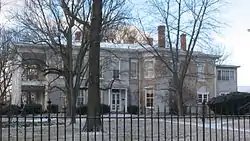 Shirk-Edwards House |
September 14, 1995 (#95001109) |
50 N. Hood St. 40°45′08″N 86°04′30″W |
Peru | |
| 14 | Wallace Circus and American Circus Corporation Winter Quarters |  Wallace Circus and American Circus Corporation Winter Quarters |
February 27, 1987 (#87000837) |
2.5 miles (4.0 km) southeast of Peru 40°45′16″N 86°01′11″W |
Butler Township | |
| 15 | Westleigh Farms |  Westleigh Farms |
September 28, 2003 (#03000976) |
2107 S. Frances Slocum Trail, east of Peru 40°44′06″N 86°00′18″W |
Butler Township |
Former listing
| [3] | Name on the Register | Image | Date listed | Date removed | Location | City or town | Summary |
|---|---|---|---|---|---|---|---|
| 1 | Paw Paw Creek Bridge No. 52 | 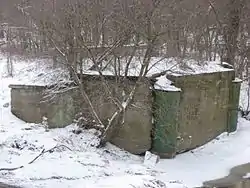 Paw Paw Creek Bridge No. 52 |
September 30, 1983 (#83000008) | October 13, 2015 | Paw Paw Pike, northeast of Chili 40°52′42″N 85°57′59″W |
Richland Township |
See also
| Wikimedia Commons has media related to National Register of Historic Places in Miami County, Indiana. |
References
- The latitude and longitude information provided in this table was derived originally from the National Register Information System, which has been found to be fairly accurate for about 99% of listings. Some locations in this table may have been corrected to current GPS standards.
- "National Register of Historic Places: Weekly List Actions". National Park Service, United States Department of the Interior. Retrieved on January 29, 2021.
- Numbers represent an alphabetical ordering by significant words. Various colorings, defined here, differentiate National Historic Landmarks and historic districts from other NRHP buildings, structures, sites or objects.
- "National Register Information System". National Register of Historic Places. National Park Service. March 13, 2009.
- The eight-digit number below each date is the number assigned to each location in the National Register Information System database, which can be viewed by clicking the number.
| Topics | |
|---|---|
| Lists by state |
|
| Lists by insular areas | |
| Lists by associated state | |
| Other areas | |
| Related | |
| |
Municipalities and communities of Miami County, Indiana, United States | ||
|---|---|---|
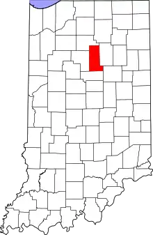
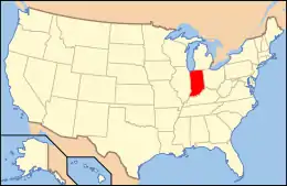
| City | Map of Indiana highlighting Miami County | |
| Towns | ||
| Townships | ||
| CDP | ||
| Other unincorporated communities | ||
| Ghost towns | ||
| Footnotes | ‡This populated place also has portions in an adjacent county or counties | |
| ||