Saint-Denis-sur-Loire
Saint-Denis-sur-Loire (French pronunciation: [sɛ̃ dəni syʁ lwaʁ]) is a commune in the Loir-et-Cher department in Centre-Val de Loire, France.
Saint-Denis-sur-Loire | |
|---|---|
Commune | |
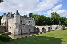 Castle of Saint-Denis-sur-Loire | |
Location of Saint-Denis-sur-Loire 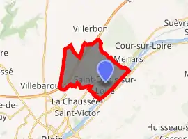
| |
 Saint-Denis-sur-Loire  Saint-Denis-sur-Loire | |
| Coordinates: 47°37′33″N 1°23′14″E | |
| Country | France |
| Region | Centre-Val de Loire |
| Department | Loir-et-Cher |
| Arrondissement | Blois |
| Canton | Blois-2 |
| Intercommunality | Blois |
| Government | |
| • Mayor (2014–2020) | Benoît Simonnin |
| Area 1 | 12.4 km2 (4.8 sq mi) |
| Population (2017-01-01)[1] | 837 |
| • Density | 68/km2 (170/sq mi) |
| Time zone | UTC+01:00 (CET) |
| • Summer (DST) | UTC+02:00 (CEST) |
| INSEE/Postal code | 41206 /41000 |
| Elevation | 69–115 m (226–377 ft) (avg. 120 m or 390 ft) |
| 1 French Land Register data, which excludes lakes, ponds, glaciers > 1 km2 (0.386 sq mi or 247 acres) and river estuaries. | |
It is a suburb of Blois, 7 km northeast of the town, and lies on the river Loire, 63 km southwest of Orléans.
Population
| Year | Pop. | ±% |
|---|---|---|
| 1793 | 868 | — |
| 1806 | 862 | −0.7% |
| 1821 | 584 | −32.3% |
| 1831 | 522 | −10.6% |
| 1841 | 509 | −2.5% |
| 1851 | 509 | +0.0% |
| 1861 | 531 | +4.3% |
| 1872 | 504 | −5.1% |
| 1881 | 554 | +9.9% |
| 1891 | 478 | −13.7% |
| 1901 | 455 | −4.8% |
| 1911 | 427 | −6.2% |
| 1921 | 415 | −2.8% |
| 1931 | 355 | −14.5% |
| 1946 | 357 | +0.6% |
| 1954 | 359 | +0.6% |
| 1962 | 357 | −0.6% |
| 1968 | 403 | +12.9% |
| 1975 | 498 | +23.6% |
| 1982 | 708 | +42.2% |
| 1990 | 907 | +28.1% |
| 1999 | 884 | −2.5% |
| 2005 | 867 | −1.9% |
| 2015 | 838 | −3.3% |
References
- "Populations légales 2017". INSEE. Retrieved 6 January 2020.
| Wikimedia Commons has media related to Saint-Denis-sur-Loire. |
| Authority control |
|---|
This article is issued from Wikipedia. The text is licensed under Creative Commons - Attribution - Sharealike. Additional terms may apply for the media files.