Saint-Julien-sur-Cher
Saint-Julien-sur-Cher is a commune in the Loir-et-Cher department in central France.
Saint-Julien-sur-Cher | |
|---|---|
Commune | |
Location of Saint-Julien-sur-Cher 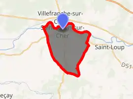
| |
 Saint-Julien-sur-Cher  Saint-Julien-sur-Cher | |
| Coordinates: 47°16′58″N 1°46′29″E | |
| Country | France |
| Region | Centre-Val de Loire |
| Department | Loir-et-Cher |
| Arrondissement | Romorantin-Lanthenay |
| Canton | Selles-sur-Cher |
| Intercommunality | Saint-Julien-sur-Cher, La Chapelle-Montmartin, Saint-Loup-sur-Cher |
| Government | |
| • Mayor (2014–2020) | Jean-Louis Marchenoir |
| Area 1 | 15.99 km2 (6.17 sq mi) |
| Population (2017-01-01)[1] | 768 |
| • Density | 48/km2 (120/sq mi) |
| Time zone | UTC+01:00 (CET) |
| • Summer (DST) | UTC+02:00 (CEST) |
| INSEE/Postal code | 41218 /41320 |
| Elevation | 82–152 m (269–499 ft) (avg. 100 m or 330 ft) |
| 1 French Land Register data, which excludes lakes, ponds, glaciers > 1 km2 (0.386 sq mi or 247 acres) and river estuaries. | |
Population
| Year | Pop. | ±% |
|---|---|---|
| 1793 | 414 | — |
| 1806 | 382 | −7.7% |
| 1821 | 417 | +9.2% |
| 1831 | 423 | +1.4% |
| 1841 | 426 | +0.7% |
| 1851 | 490 | +15.0% |
| 1861 | 510 | +4.1% |
| 1872 | 477 | −6.5% |
| 1881 | 494 | +3.6% |
| 1891 | 544 | +10.1% |
| 1901 | 534 | −1.8% |
| 1911 | 519 | −2.8% |
| 1921 | 458 | −11.8% |
| 1931 | 373 | −18.6% |
| 1946 | 376 | +0.8% |
| 1954 | 413 | +9.8% |
| 1962 | 387 | −6.3% |
| 1968 | 403 | +4.1% |
| 1975 | 447 | +10.9% |
| 1982 | 553 | +23.7% |
| 1990 | 627 | +13.4% |
| 1999 | 663 | +5.7% |
| 2006 | 737 | +11.2% |
| 2015 | 772 | +4.7% |
References
- "Populations légales 2017". INSEE. Retrieved 6 January 2020.
| Wikimedia Commons has media related to Saint-Julien-sur-Cher. |
| Authority control |
|---|
This article is issued from Wikipedia. The text is licensed under Creative Commons - Attribution - Sharealike. Additional terms may apply for the media files.