National Register of Historic Places listings in Clay County, Missouri
This is a list of the National Register of Historic Places listings in Clay County, Missouri.
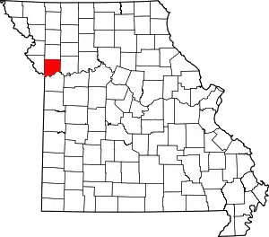
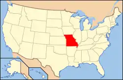
Location of Clay County in Missouri
This is intended to be a complete list of the properties and districts on the National Register of Historic Places in Clay County, Missouri, United States. Latitude and longitude coordinates are provided for many National Register properties and districts; these locations may be seen together in a map.[1]
There are 39 properties and districts listed on the National Register in the county, including 1 National Historic Landmark.
- This National Park Service list is complete through NPS recent listings posted January 29, 2021.[2]
Current listings
| [3] | Name on the Register | Image | Date listed[4] | Location | City or town | Description |
|---|---|---|---|---|---|---|
| 1 | Aker Cemetery |  Aker Cemetery |
November 13, 1974 (#74001071) |
Northeast of Smithville off MO W 39°24′40″N 94°32′44″W |
Smithville | |
| 2 | Antioch Christian Church | 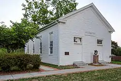 Antioch Christian Church |
April 2, 1979 (#79001358) |
4805 NE Antioch Rd. 39°10′53″N 94°32′52″W |
Kansas City | |
| 3 | Armour Theatre Building | 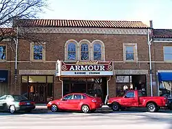 Armour Theatre Building |
June 24, 2008 (#08000560) |
400-410 Armour Rd. 39°08′33″N 94°34′32″W |
North Kansas City | |
| 4 | Arthur-Leonard Historic District | 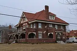 Arthur-Leonard Historic District |
January 4, 2001 (#00001608) |
Roughly bounded by Ford Ave., Jewell St., Choctaw St., and Missouri St. 39°14′41″N 94°24′56″W |
Liberty | |
| 5 | Atkins-Johnson Farmhouse Property | 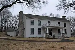 Atkins-Johnson Farmhouse Property |
November 7, 2007 (#07001154) |
6508 N Jackson Ave. 39°12′46″N 94°31′49″W |
Gladstone | |
| 6 | Boarding House District | August 24, 2018 (#100002791) |
401-608 Benton, 339-436 E Broadway, 201-223 S Francis, 105 Haynes, 309-526 Isley, 101 Linden, 110-112 Perry, 103-305 Saratoga, 000-213 Temple 39°20′28″N 94°13′04″W |
Excelsior Springs | ||
| 7 | Clay County Savings Association Building | 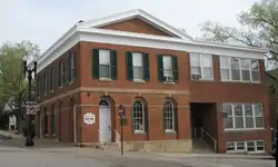 Clay County Savings Association Building |
December 28, 1992 (#92001675) |
104 E. Franklin St. 39°14′50″N 94°25′08″W |
Liberty | |
| 8 | Claybrook House | 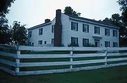 Claybrook House |
December 21, 1981 (#81000332) |
Northeast of Kearney 39°23′17″N 94°20′09″W |
Kearney | |
| 9 | Clinton House | 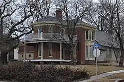 Clinton House |
November 22, 1978 (#78001641) |
404 S. Leonard St. 39°14′23″N 94°25′00″W |
Liberty | |
| 10 | Colonial Hotel | 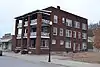 Colonial Hotel |
June 24, 2010 (#10000392) |
328 E. Broadway 39°20′33″N 94°13′13″W |
Excelsior Springs | |
| 11 | Dr. James Compton House | 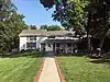 Dr. James Compton House |
July 10, 1979 (#79003677) |
5410 NE Oak Ridge Rd. 39°11′47″N 94°30′43″W |
Kansas City | |
| 12 | Dougherty-Prospect Heights Historic District | 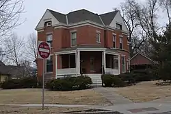 Dougherty-Prospect Heights Historic District |
January 4, 2001 (#00001605) |
Roughly bounded by Mississippi St., Gallatin St., Schrader St., and Fairview Ave. 39°14′52″N 94°25′32″W |
Liberty | |
| 13 | Downtown Smithville Historic District | April 21, 2014 (#14000159) |
Roughly bounded by Bridge, Church, Commercial & Meadow Sts. 39°23′14″N 94°34′49″W |
Smithville | ||
| 14 | The Elms Historic District |  The Elms Historic District |
March 31, 2014 (#14000091) |
Roughly 400 blk. Regent Ave., 500 blk. Elms Blvd., 500-600 blocks Kansas City Ave. 39°20′15″N 94°13′34″W |
Excelsior Springs | |
| 15 | Elms Hotel | Elms Hotel |
March 29, 1985 (#85000648) |
Regent and Elms Blvd. 39°20′14″N 94°13′32″W |
Excelsior Springs | |
| 16 | Excelsior Springs Hall of Waters Commercial East Historic District |  Excelsior Springs Hall of Waters Commercial East Historic District |
May 27, 1999 (#99000638) |
Roughly along portions of East and West Broadway and Main St. 39°20′39″N 94°13′19″W |
Excelsior Springs | |
| 17 | Excelsior Springs Hall of Waters Commercial West Historic District | 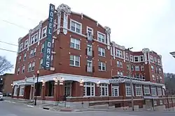 Excelsior Springs Hall of Waters Commercial West Historic District |
May 27, 1999 (#99000637) |
Roughly along portions of Thompson, and St. Louis Aves.; South, Main, Marietta, and Spring Sts.; and Elms Blvd. 39°20′33″N 94°14′13″W |
Excelsior Springs | |
| 18 | First Methodist Church | 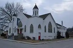 First Methodist Church |
October 28, 2009 (#09000856) |
114 N. Marietta St. 39°20′34″N 94°13′28″W |
Excelsior Springs | |
| 19 | Garrison School Historic District | .jpg.webp) Garrison School Historic District |
January 4, 2001 (#00001607) |
Roughly along N. Main St. and N. Water St. 39°15′14″N 94°25′14″W |
Liberty | |
| 20 | Hall of Waters | Hall of Waters |
June 9, 1983 (#83000977) |
201 E. Broadway 39°20′30″N 94°13′20″W |
Excelsior Springs | |
| 21 | Frank Hughes Memorial Library |  Frank Hughes Memorial Library |
December 28, 1992 (#92001676) |
210 E. Franklin St. 39°14′50″N 94°25′03″W |
Liberty | |
| 22 | IOOF Liberty Lodge No. 49 | 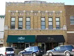 IOOF Liberty Lodge No. 49 |
December 28, 1992 (#92001677) |
16-18 E. Franklin St. 39°14′49″N 94°25′11″W |
Liberty | |
| 23 | James Brothers' House and Farm | 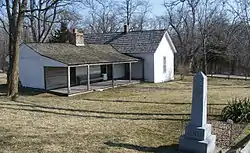 James Brothers' House and Farm |
March 16, 1972 (#72000709) |
2.25 miles (3.62 km) east of Kearney; also northeast of Kearney 39°23′36″N 94°19′18″W |
Kearney | Northeast of Kearney represents a boundary increase of September 27, 1978 |
| 24 | Jewell Hall | 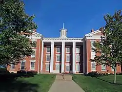 Jewell Hall |
September 6, 1978 (#78001642) |
Jewell St. between Kansas and Mississippi Sts. 39°14′49″N 94°24′44″W |
Liberty | |
| 25 | Jewell-Lightburne Historic District |  Jewell-Lightburne Historic District |
January 4, 2001 (#00001606) |
Roughly bounded by N. Jewell St., E. Mill St., Main St. and Gordon St. 39°14′53″N 94°24′54″W |
Liberty | |
| 26 | Ligon Apartments | 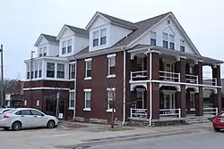 Ligon Apartments |
May 17, 2010 (#10000265) |
211 E Excelsior St. 39°20′34″N 94°13′18″W |
Excelsior Springs | |
| 27 | Major Hotel | 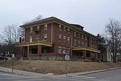 Major Hotel |
December 28, 1992 (#92001678) |
112 E. Franklin St. 39°14′50″N 94°25′06″W |
Liberty | |
| 28 | Miller Building | 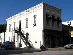 Miller Building |
December 28, 1992 (#92001679) |
2 E. Franklin St. 39°14′50″N 94°25′12″W |
Liberty | |
| 29 | Missouri City Savings Bank Building and Meeting Hall | 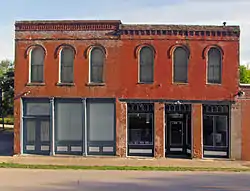 Missouri City Savings Bank Building and Meeting Hall |
July 30, 2010 (#10000507) |
417-419 Main St. 39°14′18″N 94°17′39″W |
Missouri City | |
| 30 | Mt. Memorial Cemetery | 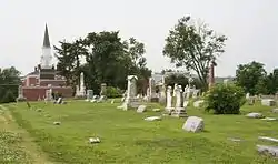 Mt. Memorial Cemetery |
April 24, 2012 (#12000231) |
500 block E. Mississippi St. 39°14′56″N 94°24′45″W |
Liberty | |
| 31 | Nebo Hill Archeological Site | March 4, 1971 (#71000465) |
Summit of Nebo Hill[5] 39°12′40″N 94°21′22″W |
Liberty | ||
| 32 | Odd Fellows Home District | Odd Fellows Home District |
September 15, 1987 (#87001595) |
MO 291 39°13′47″N 94°24′30″W |
Liberty | |
| 33 | Sears, Roebuck and Company Warehouse Building | 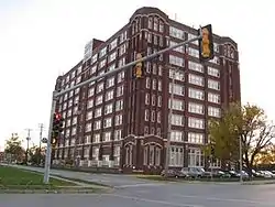 Sears, Roebuck and Company Warehouse Building |
May 9, 1997 (#97000411) |
715 Armour Rd. 39°08′32″N 94°34′17″W |
North Kansas City | |
| 34 | South Liberty Courthouse Square Historic District | 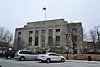 South Liberty Courthouse Square Historic District |
December 28, 1992 (#92001680) |
2 S. Main St., 10 E. Kansas St., 1-17 E. Kansas St. 39°14′45″N 94°25′11″W |
Liberty | |
| 35 | Watkins Mill | .jpg.webp) Watkins Mill |
November 13, 1966 (#66000416) |
6 miles (9.7 km) northwest of Excelsior 39°24′36″N 94°15′45″W |
Excelsior Springs | |
| 36 | West Liberty Courthouse Square Historic District | December 28, 1992 (#92001681) |
12-16 N. Main St. 39°14′47″N 94°25′14″W |
Liberty | ||
| 37 | Wheeling Corrugating Company Building | 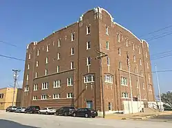 Wheeling Corrugating Company Building |
October 21, 1994 (#94001220) |
820 E. 14th Ave. 39°08′04″N 94°34′14″W |
North Kansas City | |
| 38 | Woodneath |  Woodneath |
February 17, 1978 (#78001640) |
8900 NE Flintlock Rd. 39°15′12″N 94°28′03″W |
Kansas City | |
| 39 | Wyman School |  Wyman School |
July 24, 2008 (#08000695) |
100 Dunbar St. 39°20′23″N 94°13′41″W |
Excelsior Springs |
See also
References
| Wikimedia Commons has media related to National Register of Historic Places in Clay County, Missouri. |
- The latitude and longitude information provided in this table was derived originally from the National Register Information System, which has been found to be fairly accurate for about 99% of listings. Some locations in this table may have been corrected to current GPS standards.
- "National Register of Historic Places: Weekly List Actions". National Park Service, United States Department of the Interior. Retrieved on January 29, 2021.
- Numbers represent an alphabetical ordering by significant words. Various colorings, defined here, differentiate National Historic Landmarks and historic districts from other NRHP buildings, structures, sites or objects.
- The eight-digit number below each date is the number assigned to each location in the National Register Information System database, which can be viewed by clicking the number.
- Logan, Brad. National Register of Historic Places Inventory/Nomination: Prehistoric Sites of Stranger Creek Basin, Kansas. National Park Service, 2003-12-20, 11. Accessed 2013-04-03.
| Topics | |
|---|---|
| Lists by state |
|
| Lists by insular areas | |
| Lists by associated state | |
| Other areas | |
| Related | |
| |
Municipalities and communities of Clay County, Missouri, United States | ||
|---|---|---|
| Cities | Map of Missouri highlighting Clay County | |
| Villages | ||
| Townships | ||
| Unincorporated communities | ||
| Footnotes | ‡This populated place also has portions in an adjacent county or counties | |
| ||
This article is issued from Wikipedia. The text is licensed under Creative Commons - Attribution - Sharealike. Additional terms may apply for the media files.