National Register of Historic Places listings in Monroe County, Missouri
This is a list of the National Register of Historic Places listings in Monroe County, Missouri.
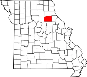
Location of Monroe County in Missouri
This is intended to be a complete list of the properties and districts on the National Register of Historic Places in Monroe County, Missouri, United States. Latitude and longitude coordinates are provided for many National Register properties and districts; these locations may be seen together in a map.[1]
There are 10 properties and districts listed on the National Register in the county.
- This National Park Service list is complete through NPS recent listings posted January 29, 2021.[2]
Current listings
| [3] | Name on the Register | Image | Date listed[4] | Location | City or town | Description |
|---|---|---|---|---|---|---|
| 1 | Crigler Mound Group Archeological Site | May 21, 1969 (#69000115) |
Crigler Cemetery, north of Florida[5] 39°30′45″N 91°45′02″W |
Florida | ||
| 2 | Farmers and Merchants Bank Building |  Farmers and Merchants Bank Building |
January 12, 2012 (#11001020) |
201-207 S. Main St. 39°39′08″N 91°44′05″W |
Monroe City | |
| 3 | Holliday Petroglyphs | January 11, 1974 (#74001083) |
Northern half of the southeastern quarter of Section 34, Township 55 North, Range 11 West, northeast of Holliday[6] 39°30′23″N 92°07′05″W |
Holliday | ||
| 4 | Mark Twain State Park Picnic Shelter at Buzzard's Roost |  Mark Twain State Park Picnic Shelter at Buzzard's Roost |
March 4, 1985 (#85000515) |
Off Route 107 39°28′23″N 91°47′37″W |
Santa Fe | |
| 5 | Paris Male Academy |  Paris Male Academy |
July 19, 1990 (#90001103) |
411 E. Monroe St. 39°28′56″N 91°59′40″W |
Paris | |
| 6 | St. Jude's Episcopal Church |  St. Jude's Episcopal Church |
November 22, 2000 (#00001397) |
301 N. Main St. 39°39′16″N 91°44′05″W |
Monroe City | |
| 7 | Mark Twain Birthplace Cabin |  Mark Twain Birthplace Cabin |
May 21, 1969 (#69000116) |
Mark Twain State Park, 2.5 miles (4.0 km) south of Florida on Route 107 39°30′48″N 91°45′06″W |
Florida | |
| 8 | Union Covered Bridge |  Union Covered Bridge |
June 15, 1970 (#70000342) |
6 miles (9.7 km) west of Paris on Elk Fork of the Salt River 39°25′58″N 92°06′08″W |
Paris | |
| 9 | Merritt Violette House | 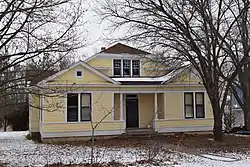 Merritt Violette House |
September 8, 1983 (#83001031) |
Off Route 107 39°29′37″N 91°47′06″W |
Florida | |
| 10 | Washington School |  Washington School |
December 29, 1994 (#94001502) |
529 S. Locust St. 39°38′17″N 91°44′12″W |
Monroe City |
See also
References
| Wikimedia Commons has media related to National Register of Historic Places in Monroe County, Missouri. |
- The latitude and longitude information provided in this table was derived originally from the National Register Information System, which has been found to be fairly accurate for about 99% of listings. Some locations in this table may have been corrected to current GPS standards.
- "National Register of Historic Places: Weekly List Actions". National Park Service, United States Department of the Interior. Retrieved on January 29, 2021.
- Numbers represent an alphabetical ordering by significant words. Various colorings, defined here, differentiate National Historic Landmarks and historic districts from other NRHP buildings, structures, sites or objects.
- The eight-digit number below each date is the number assigned to each location in the National Register Information System database, which can be viewed by clicking the number.
- Outline Interpretive Concept Inventory Archived 2014-09-15 at the Wayback Machine, Missouri Water Information Network, n.d., 24. Accessed 2013-03-24.
- Eichenberger, J. Allen. "Investigations of the Marion-Ralls Archaeological Society in Northeast Missouri". Missouri Archaeologist 19 (1944): 1-69:61.
| Topics | |
|---|---|
| Lists by state |
|
| Lists by insular areas | |
| Lists by associated state | |
| Other areas | |
| Related | |
| |
Municipalities and communities of Monroe County, Missouri, United States | ||
|---|---|---|
| Cities | Map of Missouri highlighting Monroe County | |
| Villages | ||
| Townships | ||
| Unincorporated communities | ||
| Footnotes | ‡This populated place also has portions in an adjacent county or counties | |
| ||
This article is issued from Wikipedia. The text is licensed under Creative Commons - Attribution - Sharealike. Additional terms may apply for the media files.