National Register of Historic Places listings in Dent County, Missouri
This is a list of the National Register of Historic Places listings in Dent County, Missouri.
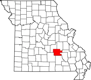
Location of Dent County in Missouri
This is intended to be a complete list of the properties and districts on the National Register of Historic Places in Dent County, Missouri, United States. Latitude and longitude coordinates are provided for many National Register properties and districts; these locations may be seen together in a map.[1]
There are 8 properties and districts listed on the National Register in the county.
- This National Park Service list is complete through NPS recent listings posted January 29, 2021.[2]
Current listings
| [3] | Name on the Register | Image | Date listed[4] | Location | City or town | Description |
|---|---|---|---|---|---|---|
| 1 | Dam and Spillway in the Hatchery Area at Montauk State Park |  Dam and Spillway in the Hatchery Area at Montauk State Park |
February 26, 1985 (#85000528) |
Off Route 119 37°27′19″N 91°41′05″W |
Salem | |
| 2 | Dent County Courthouse | 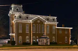 Dent County Courthouse |
February 23, 1972 (#72000711) |
Main and 4th Sts. 37°38′44″N 91°32′08″W |
Salem | |
| 3 | Lower Parker School | 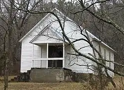 Lower Parker School |
May 31, 1991 (#91000604) |
Eastern bank of the Current River at Parker Hollow, Ozark National Scenic Riverways 37°26′22″N 91°37′24″W |
Salem | |
| 4 | Montauk State Park Open Shelter |  Montauk State Park Open Shelter |
February 28, 1985 (#85000529) |
Off Route 119 37°27′01″N 91°41′16″W |
Salem | |
| 5 | Nichols Farm District | 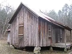 Nichols Farm District |
December 27, 1989 (#89002129) |
West of County Road V, north of the Current River 37°26′31″N 91°37′13″W |
Cedar Grove | |
| 6 | Nova Scotia Ironworks Historic District | August 25, 2003 (#03000793) |
Mark Twain National Forest 37°30′47″N 91°19′47″W |
Salem | ||
| 7 | Old Mill at Montauk State Park |  Old Mill at Montauk State Park |
June 27, 1985 (#85001478) |
Off Route 119 37°27′02″N 91°41′00″W |
Salem | |
| 8 | W.A. Young House | March 30, 1989 (#88000147) |
County Road 513 37°37′02″N 91°27′25″W |
Salem |
See also
References
| Wikimedia Commons has media related to National Register of Historic Places in Dent County, Missouri. |
- The latitude and longitude information provided in this table was derived originally from the National Register Information System, which has been found to be fairly accurate for about 99% of listings. Some locations in this table may have been corrected to current GPS standards.
- "National Register of Historic Places: Weekly List Actions". National Park Service, United States Department of the Interior. Retrieved on January 29, 2021.
- Numbers represent an alphabetical ordering by significant words. Various colorings, defined here, differentiate National Historic Landmarks and historic districts from other NRHP buildings, structures, sites or objects.
- The eight-digit number below each date is the number assigned to each location in the National Register Information System database, which can be viewed by clicking the number.
| Topics | |
|---|---|
| Lists by state |
|
| Lists by insular areas | |
| Lists by associated state | |
| Other areas | |
| Related | |
| |
Municipalities and communities of Dent County, Missouri, United States | ||
|---|---|---|
| Cities | Map of Missouri highlighting Dent County | |
| Townships |
| |
| Unincorporated communities | ||
| Ghost towns | ||
| Footnotes | ‡This populated place also has portions in an adjacent county or counties | |
| ||
This article is issued from Wikipedia. The text is licensed under Creative Commons - Attribution - Sharealike. Additional terms may apply for the media files.