National Register of Historic Places listings in Saline County, Missouri
This is a list of the National Register of Historic Places listings in Saline County, Missouri.
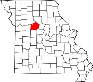
Location of Saline County in Missouri
This is intended to be a complete list of the properties and districts on the National Register of Historic Places in Saline County, Missouri, United States. Latitude and longitude coordinates are provided for many National Register properties and districts; these locations may be seen together in a map.[1]
There are 32 properties and districts listed on the National Register in the county, including 3 National Historic Landmarks.
- This National Park Service list is complete through NPS recent listings posted January 29, 2021.[2]
Current listings
| [3] | Name on the Register | Image | Date listed[4] | Location | City or town | Description |
|---|---|---|---|---|---|---|
| 1 | Arrow Rock Ferry Landing | May 1, 2013 (#08000664) |
Northern extension of 2nd St.[5] 39°04′27″N 92°56′37″W |
Arrow Rock | ||
| 2 | Arrow Rock | Arrow Rock |
October 15, 1966 (#66000422) |
Arrow Rock State Park 39°04′00″N 92°56′41″W |
Arrow Rock | |
| 3 | Arrow Rock State Historic Site Bridge | March 4, 1985 (#85000516) |
Southeast of Arrow Rock 39°04′06″N 92°56′39″W |
Arrow Rock | ||
| 4 | Arrow Rock State Historic Site Grave Shelter | February 27, 1985 (#85000534) |
Southeast of Arrow Rock 39°04′06″N 92°56′39″W |
Arrow Rock | ||
| 5 | Arrow Rock State Historic Site Lookout Shelter | February 27, 1985 (#85000535) |
East of Arrow Rock 39°04′16″N 92°56′33″W |
Arrow Rock | ||
| 6 | Arrow Rock State Historic Site Open Shelter | February 28, 1985 (#85000536) |
Southeast of Arrow Rock 39°04′04″N 92°56′31″W |
Arrow Rock | ||
| 7 | Arrow Rock Tavern | Arrow Rock Tavern |
February 23, 1972 (#72000729) |
Main St. 39°04′03″N 92°56′42″W |
Arrow Rock | |
| 8 | Baity Hall | 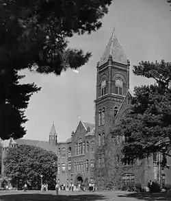 Baity Hall |
June 25, 1986 (#86001396) |
Missouri Valley College, 500 E. College 39°06′28″N 93°11′23″W |
Marshall | |
| 9 | George Caleb Bingham House | George Caleb Bingham House |
October 15, 1966 (#66000423) |
1st and High Sts. in Arrow Rock State Park 39°04′15″N 92°56′35″W |
Arrow Rock | |
| 10 | Henry Blosser House | December 29, 1978 (#78001675) |
East of Malta Bend off U.S. 65 39°11′24″N 93°17′28″W |
Malta Bend | ||
| 11 | Buckner House | .jpg.webp) Buckner House |
April 19, 1984 (#84002581) |
125 N. Brunswick Ave. 39°07′22″N 93°11′25″W |
Marshall | |
| 12 | Chicago and Alton Depot | .jpg.webp) Chicago and Alton Depot |
June 27, 1979 (#79001395) |
Sebree St. 39°07′31″N 93°11′54″W |
Marshall | |
| 13 | First Christian Church | 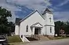 First Christian Church |
September 12, 1980 (#80002394) |
400 Bridge St. 38°57′46″N 93°25′09″W |
Sweet Springs | |
| 14 | First Presbyterian Church | .jpg.webp) First Presbyterian Church |
September 20, 1977 (#77000814) |
212 E. North St. 39°07′15″N 93°11′39″W |
Marshall | |
| 15 | Fisher-Gabbert Archeological Site | March 16, 1972 (#72000730) |
1 mile (1.6 km) northeast of central Miami[6] 39°19′51″N 93°12′48″W |
Miami | ||
| 16 | Fitzgibbon Hospital | .jpg.webp) Fitzgibbon Hospital |
October 17, 2012 (#12000874) |
868 S. Brunswick Ave. 39°06′44″N 93°11′25″W |
Marshall | |
| 17 | Free Will Baptist Church of Pennytown | April 19, 1988 (#88000388) |
Off MO UU 8 miles (13 km) southeast of Marshall 39°00′59″N 93°10′47″W |
Marshall | ||
| 18 | Gumbo Point Archeological Site | August 25, 1969 (#69000125) |
Southern side of the Missouri River, 2 miles (3.2 km) north of the junction of U.S. Route 65 and Route 127[7] 39°13′33″N 93°23′18″W |
Grand Pass | ||
| 19 | Guthrey Archeological Site | December 2, 1970 (#70000349) |
2 miles (3.2 km) east of Miami[8] 39°20′04″N 93°11′34″W |
Miami | ||
| 20 | Mt. Carmel Historic District | November 10, 2009 (#09000900) |
290th Rd. and Missouri Highway 41 North 39°12′39″N 93°13′09″W |
Marshall | ||
| 21 | George A. Murrell House | November 14, 1997 (#97001435) |
0.75 miles (1.21 km) east and 0.5 miles (0.80 km) north of MO E and H 39°02′17″N 93°04′25″W |
Napton | ||
| 22 | Neff Tavern Smokehouse | November 30, 1978 (#78001676) |
Northeast of Napton off MO 41 39°05′48″N 93°02′39″W |
Napton | ||
| 23 | Old Fort | Old Fort |
January 13, 1972 (#72000731) |
Van Meter State Park[9] 39°16′22″N 93°15′49″W |
Miami | |
| 24 | Plattner Archeological Site | March 4, 1971 (#71000474) |
1 mile (1.6 km) north of Malta Bend[8] 39°12′38″N 93°21′24″W |
Malta Bend | ||
| 25 | Saline County Courthouse |  Saline County Courthouse |
August 24, 1977 (#77000815) |
Courthouse Sq. 39°07′15″N 93°11′47″W |
Marshall | |
| 26 | Santa Fe Trail-Grand Pass Trail Segments | April 21, 1994 (#94000324) |
Junction of US 65 and County Road T 39°11′43″N 93°26′29″W |
Grand Pass | ||
| 27 | Santa Fe Trail-Saline County Trail Segments | June 30, 1994 (#94000615) |
Co. Rd. 416 (Rural Rt. 3) west of junction with MO 41 39°11′17″N 93°14′21″W |
Stanhope | ||
| 28 | William B. Sappington House |  William B. Sappington House |
January 21, 1970 (#70000348) |
3 miles (4.8 km) southwest of Arrow Rock on CR TT 39°02′24″N 92°59′09″W |
Arrow Rock | |
| 29 | Sweet Springs Historic District | 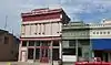 Sweet Springs Historic District |
December 10, 1997 (#97001485) |
200-217 W. Lexington Ave and 211 Marshall St. 38°57′54″N 93°25′04″W |
Sweet Springs | Originally roughly along Lexington, Marshall, Miller, and Spring Sts., until a boundary decrease of April 26, 2010 |
| 30 | Utz Site | October 15, 1966 (#66000424) |
Southern half of Section 19, Township 52 North, Range 21 West[8] 39°16′23″N 93°15′12″W |
Marshall | Site is a full mile long from southwest to northeast[8] | |
| 31 | Van Meter State Park Combination Building | February 27, 1985 (#85000537) |
Van Meter State Park 39°15′53″N 93°16′05″W |
Marshall | ||
| 32 | Van Meter State Park Shelter Building | February 28, 1985 (#85000538) |
Van Meter State Park 39°15′57″N 93°16′09″W |
Marshall |
See also
References
| Wikimedia Commons has media related to National Register of Historic Places in Saline County, Missouri. |
- The latitude and longitude information provided in this table was derived originally from the National Register Information System, which has been found to be fairly accurate for about 99% of listings. Some locations in this table may have been corrected to current GPS standards.
- "National Register of Historic Places: Weekly List Actions". National Park Service, United States Department of the Interior. Retrieved on January 29, 2021.
- Numbers represent an alphabetical ordering by significant words. Various colorings, defined here, differentiate National Historic Landmarks and historic districts from other NRHP buildings, structures, sites or objects.
- The eight-digit number below each date is the number assigned to each location in the National Register Information System database, which can be viewed by clicking the number.
- Places To Go in Missouri, National Park Service, 2010-04-06. Accessed 2013-05-17.
- Artz, Joe Alan. "Inferring Season of Occupation from Fish Scales: An Archaeological Approach". Plains Anthropologist 25.87 (1980): 47-61: 52.
- O'Brien, Patricia J., and Kevin Hart. "The Utlaut Site (23SA162W): An Oneota-Historic Missouri Burial Site". Missouri Archaeologist 34.1-2 (1972): 48-74: 49.
- Bray, Robert T. "European Trade Goods from the Utz Site and the Search for Fort Orleans". Missouri Archaeologist 39 Whole Volume (1978): 24.
- Berry, Brewton. "The 'Old Fort' in Saline County". Missouri Archaeologist 5.1 (1939): 3-6: 3.
| Topics | |
|---|---|
| Lists by state |
|
| Lists by insular areas | |
| Lists by associated state | |
| Other areas | |
| Related | |
| |
Municipalities and communities of Saline County, Missouri, United States | ||
|---|---|---|
| Cities | Map of Missouri highlighting Saline County | |
| Villages | ||
| Townships | ||
| Unincorporated communities | ||
| Ghost towns | ||
| Footnotes | ‡This populated place also has portions in an adjacent county or counties | |
| ||
This article is issued from Wikipedia. The text is licensed under Creative Commons - Attribution - Sharealike. Additional terms may apply for the media files.