National Register of Historic Places listings in Cleveland County, Arkansas
This is a list of the National Register of Historic Places listings in Cleveland County, Arkansas.

Location of Cleveland County in Arkansas
This is intended to be a complete list of the properties and districts on the National Register of Historic Places in Cleveland County, Arkansas, United States. The locations of National Register properties and districts for which the latitude and longitude coordinates are included below, may be seen in a map.[1]
There are 13 properties and districts listed on the National Register in the county, including 1 National Historic Landmark. Another three properties were once listed but were removed.
- This National Park Service list is complete through NPS recent listings posted February 5, 2021.[2]
Current listings
| [3] | Name on the Register[4] | Image | Date listed[5] | Location | City or town | Description |
|---|---|---|---|---|---|---|
| 1 | Attwood-Hopson House | 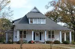 Attwood-Hopson House |
August 16, 1994 (#94000848) |
Northern side of Highway 8 33°45′35″N 92°14′27″W |
New Edinburg | |
| 2 | Barnett-Attwood House | 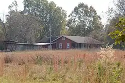 Barnett-Attwood House |
July 29, 1977 (#77000247) |
Northeast of New Edinburg 33°46′50″N 92°13′07″W |
New Edinburg | |
| 3 | Cleveland County Clerk's Building | 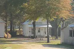 Cleveland County Clerk's Building |
January 31, 1976 (#76000394) |
Fairgrounds 33°57′12″N 92°11′30″W |
Rison | |
| 4 | Cleveland County Courthouse | 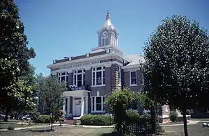 Cleveland County Courthouse |
April 11, 1977 (#77000248) |
Main and Magnolia 33°57′33″N 92°11′04″W |
Rison | |
| 5 | Magnolia Petroleum Company Filling Station | January 24, 2019 (#100003325) |
SW of intersection of Larch & 1st Sts. 33°51′32″N 92°17′44″W |
Kingsland | ||
| 6 | Marks' Mills Battlefield Park |  Marks' Mills Battlefield Park |
January 21, 1970 (#70000119) |
Junction of Highways 8 and 97 33°47′00″N 92°15′12″W |
Fordyce | Site of the Battle of Marks' Mills; one of the Camden Expedition Sites, a National Historic Landmark consisting of sites in several counties |
| 7 | Mount Olivet Methodist Church | 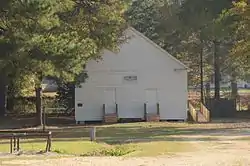 Mount Olivet Methodist Church |
December 1, 1975 (#75000377) |
Fairgrounds off Highway 35 33°57′13″N 92°11′30″W |
Rison | |
| 8 | New Edinburg Commercial Historic District | 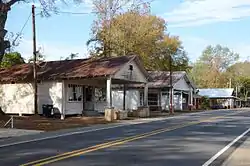 New Edinburg Commercial Historic District |
October 22, 2001 (#01001118) |
Highway 8 33°45′31″N 92°14′24″W |
New Edinburg | |
| 9 | Old US 79, Kingsland Segment | 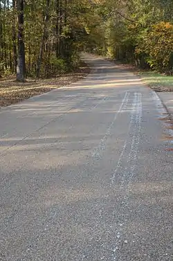 Old US 79, Kingsland Segment |
September 28, 2005 (#05001067) |
County Road 22 between U.S. Route 79 and Kight Rd. 33°51′46″N 92°18′23″W |
Kingsland | |
| 10 | Phoenix Hotel | October 4, 2002 (#02001071) |
108 Main St. 33°57′36″N 92°11′27″W |
Rison | ||
| 11 | Rison Cities Service Station | 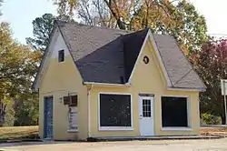 Rison Cities Service Station |
May 10, 2001 (#01000486) |
308 Main St. 33°57′31″N 92°11′24″W |
Rison | |
| 12 | Rison Texaco Service Station | 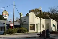 Rison Texaco Service Station |
March 25, 2002 (#01001243) |
216 Main St. 33°57′34″N 92°11′26″W |
Rison | |
| 13 | Wesley Chapel | 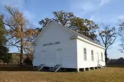 Wesley Chapel |
December 7, 1995 (#95001412) |
Highway 15 34°00′12″N 92°02′27″W |
Woodlawn |
Former listing
| [3] | Name on the Register | Image | Date listed | Date removed | Location | City or town | Summary |
|---|---|---|---|---|---|---|---|
| 1 | Federal Building | July 21, 2000 (#00000752) | June 1, 2005 | 20 Magnolia St. |
Rison | ||
| 2 | Hall Morgan Post 83, American Legion Hut | May 19, 2003 (#03000399) | September 18, 2013 | 208 Sycamore St. 33°57′30″N 92°11′18″W |
Rison | ||
| 3 | Mount Carmel Methodist Church | October 4, 1984 (#84000004) | June 3, 1986 | N of Rison off US 79 |
Rison vicinity |
See also
| Wikimedia Commons has media related to National Register of Historic Places in Cleveland County, Arkansas. |
References
- The latitude and longitude information provided in this table was derived originally from the National Register Information System, which has been found to be fairly accurate for about 99% of listings. Some locations in this table may have been corrected to current GPS standards.
- "National Register of Historic Places: Weekly List Actions". National Park Service, United States Department of the Interior. Retrieved on February 5, 2021.
- Numbers represent an alphabetical ordering by significant words. Various colorings, defined here, differentiate National Historic Landmarks and historic districts from other NRHP buildings, structures, sites or objects.
- "National Register Information System". National Register of Historic Places. National Park Service. March 13, 2009.
- The eight-digit number below each date is the number assigned to each location in the National Register Information System database, which can be viewed by clicking the number.
| Topics | |
|---|---|
| Lists by state |
|
| Lists by insular areas | |
| Lists by associated state | |
| Other areas | |
| Related | |
| |
Municipalities and communities of Cleveland County, Arkansas, United States | ||
|---|---|---|
| Cities | Map of Arkansas highlighting Cleveland County | |
| CDPs | ||
| Unincorporated communities | ||
| ||
This article is issued from Wikipedia. The text is licensed under Creative Commons - Attribution - Sharealike. Additional terms may apply for the media files.