National Register of Historic Places listings in Montgomery County, Arkansas
This is a list of the National Register of Historic Places listings in Montgomery County, Arkansas.
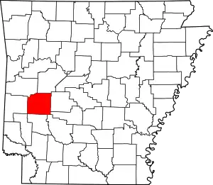
Location of Montgomery County in Arkansas
This is intended to be a complete list of the properties and districts on the National Register of Historic Places in Montgomery County, Arkansas, United States. The locations of National Register properties and districts for which the latitude and longitude coordinates are included below, may be seen in a map.[1]
There are 14 properties and districts listed on the National Register in the county. One other property was once listed but have been removed.
- This National Park Service list is complete through NPS recent listings posted February 5, 2021.[2]
Current listings
| [3] | Name on the Register | Image | Date listed[4] | Location | City or town | Description |
|---|---|---|---|---|---|---|
| 1 | Arkansas Research and Test Station (ARTS) | September 21, 2017 (#100001650) |
Reganda Springs Trail 34°22′12″N 93°39′57″W |
Caddo Gap | ||
| 2 | Caddo Valley Academy Complex |  Caddo Valley Academy Complex |
May 16, 2002 (#02000485) |
Jct. 9th St. and Smokey Hollow Rd. 34°27′21″N 93°40′45″W |
Norman | |
| 3 | CCC Company 741 Powder Magazine Historic District | March 30, 2007 (#07000201) |
Forest Service Road 177M, northeast of Norman 34°28′56″N 93°36′30″W |
Norman | ||
| 4 | Cogburn Dipping Vat | June 7, 2006 (#06000467) |
West of Forest Service Road 73, east of County Road 1 south of its junction with Highway 8 34°26′44″N 93°47′00″W |
Black Springs | ||
| 5 | Collier Springs Shelter | 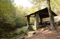 Collier Springs Shelter |
October 20, 1993 (#93001083) |
Forest Service Road 177, northeast of Norman, in the Ouachita National Forest 34°29′01″N 93°35′33″W |
Norman | |
| 6 | Crystal Springs Camp Shelter | 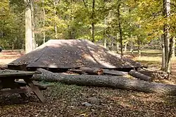 Crystal Springs Camp Shelter |
October 21, 1993 (#93001087) |
Forest Service Road 177 east of Highway 27 in the Ouachita National Forest 34°28′46″N 93°38′17″W |
Norman | Demolished by falling tree, 2016 |
| 7 | Crystal Springs Dam | October 21, 1993 (#93001088) |
Forest Service Road 177 east of Highway 27 in the Ouachita National Forest 34°28′45″N 93°38′15″W |
Norman | ||
| 8 | Guinn Dipping Vat | June 7, 2006 (#06000465) |
South of Forest Service Road 37 west of U.S. Route 70 34°35′33″N 93°40′28″W |
Mauldin | ||
| 9 | Huddleston Store and McKinzie Store |  Huddleston Store and McKinzie Store |
October 4, 1984 (#84000007) |
Highway 88 34°35′00″N 93°54′18″W |
Pine Ridge | |
| 10 | Montgomery County Courthouse |  Montgomery County Courthouse |
August 27, 1976 (#76000441) |
Court Sq. 34°33′28″N 93°37′56″W |
Mount Ida | |
| 11 | Mount Ida Cities Service Filling Station |  Mount Ida Cities Service Filling Station |
November 19, 2001 (#01001230) |
204 Whittington 34°33′23″N 93°38′01″W |
Mount Ida | |
| 12 | Norman Town Square |  Norman Town Square |
February 25, 1993 (#93000092) |
Bounded by Highway 8 and 8th, Gurdon, and 7th Sts. 34°27′17″N 93°40′49″W |
Norman | |
| 13 | Reeves-Melson House | 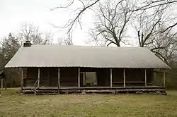 Reeves-Melson House |
December 5, 1985 (#85003069) |
Southeast of Montgomery adjacent to a branch of Mazarn Creek 34°26′09″N 93°24′37″W |
Bonnerdale | |
| 14 | Womble District Administration House No. 1 |  Womble District Administration House No. 1 |
October 20, 1993 (#93001101) |
Northern side of U.S. Route 270, east of Mt. Ida 34°32′22″N 93°36′09″W |
Mount Ida |
Former listings
| [3] | Name on the Register | Image | Date listed | Date removed | Location | City or town | Summary |
|---|---|---|---|---|---|---|---|
| 1 | Mount Ida Esso Service Station | November 19, 2001 (#01001231) | September 24, 2012 | 114 U.S. Route 270 34°33′29″N 93°37′55″W |
Mount Ida |
See also
| Wikimedia Commons has media related to National Register of Historic Places in Montgomery County, Arkansas. |
References
- The latitude and longitude information provided in this table was derived originally from the National Register Information System, which has been found to be fairly accurate for about 99% of listings. Some locations in this table may have been corrected to current GPS standards.
- "National Register of Historic Places: Weekly List Actions". National Park Service, United States Department of the Interior. Retrieved on February 5, 2021.
- Numbers represent an alphabetical ordering by significant words. Various colorings, defined here, differentiate National Historic Landmarks and historic districts from other NRHP buildings, structures, sites or objects.
- The eight-digit number below each date is the number assigned to each location in the National Register Information System database, which can be viewed by clicking the number.
| Topics | |
|---|---|
| Lists by state |
|
| Lists by insular areas | |
| Lists by associated state | |
| Other areas | |
| Related | |
| |
Municipalities and communities of Montgomery County, Arkansas, United States | ||
|---|---|---|
| City | Map of Arkansas highlighting Montgomery County | |
| Towns | ||
| Unincorporated communities | ||
| Footnotes | ‡This populated place also has portions in an adjacent county or counties | |
| ||
This article is issued from Wikipedia. The text is licensed under Creative Commons - Attribution - Sharealike. Additional terms may apply for the media files.