National Register of Historic Places listings in Cross County, Arkansas
This is a list of the National Register of Historic Places listings in Cross County, Arkansas.
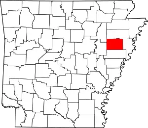
Location of Cross County in Arkansas
This is intended to be a complete list of the properties and districts on the National Register of Historic Places in Cross County, Arkansas, United States. The locations of National Register properties and districts for which the latitude and longitude coordinates are included below, may be seen in a map.[1]
There are 19 properties and districts listed on the National Register in the county, including 1 National Historic Landmark.
- This National Park Service list is complete through NPS recent listings posted February 5, 2021.[2]
Current listings
| [3] | Name on the Register[4] | Image | Date listed[5] | Location | City or town | Description |
|---|---|---|---|---|---|---|
| 1 | Isaac Block House | July 15, 1998 (#98000851) |
404 E. Hamilton St. 35°13′35″N 90°47′19″W |
Wynne | ||
| 2 | Capt. Isaac N. Deadrick House | September 16, 1993 (#93000964) |
Northwest of the junction of U.S. Route 64 and Highway 163 35°15′02″N 90°42′44″W |
Levesque | ||
| 3 | East Hamilton Avenue Historic District | 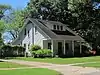 East Hamilton Avenue Historic District |
June 8, 2011 (#11000330) |
E. Hamilton Ave. between N. Falls Blvd. & N. Killough Rd.; Eldridge Ct. 35°13′31″N 90°48′51″W |
Wynne | |
| 4 | Giboney-Robertson-Stewart House | 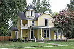 Giboney-Robertson-Stewart House |
June 5, 1998 (#98000585) |
734 Hamilton Ave. 35°13′32″N 90°47′05″W |
Wynne | |
| 5 | Grace Episcopal Church | 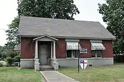 Grace Episcopal Church |
March 5, 1992 (#92000106) |
614 E. Poplar St. 35°13′40″N 90°47′12″W |
Wynne | |
| 6 | John H. Johnston Cotton Gin Historic District |  John H. Johnston Cotton Gin Historic District |
June 1, 2005 (#05000490) |
Junction of U.S. Route 64 and Highway 163 35°15′01″N 90°42′48″W |
Levesque | |
| 7 | Memphis to Little Rock Road-Strong's Ferry Segment | May 15, 2012 (#12000274) |
Address Restricted |
Jennette vicinity | part of the Cherokee Trail of Tears Multiple Property Submission | |
| 8 | Memphis to Little Rock Road-Village Creek Segment | 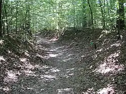 Memphis to Little Rock Road-Village Creek Segment |
April 11, 2003 (#03000193) |
East of Lake Austell within Village Creek State Park 35°08′48″N 90°43′00″W |
Newcastle | A segment of the Trail of Tears |
| 9 | New Hope School | 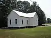 New Hope School |
November 12, 2008 (#08001037) |
3762 Highway 284 35°12′26″N 90°43′56″W |
Wynne | |
| 10 | Northern Ohio School | 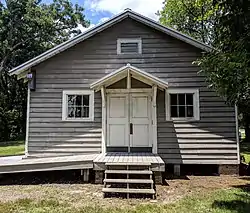 Northern Ohio School |
May 23, 2014 (#14000247) |
60 Highway 84N 35°16′47″N 90°33′28″W |
Parkin | |
| 11 | Servetus W. Ogan House | 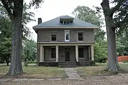 Servetus W. Ogan House |
September 28, 2015 (#15000624) |
504 E. Forrest Ave. 35°13′42″N 90°47′15″W |
Wynne | |
| 12 | Parkin Indian Mound |  Parkin Indian Mound |
October 15, 1966 (#66000200) |
Junction of U.S. Route 64 and Highway 184[6] 35°16′38″N 90°33′27″W |
Parkin | |
| 13 | South Elementary School | 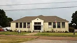 South Elementary School |
May 24, 2006 (#06000419) |
711 E. Union Ave. 35°13′31″N 90°47′09″W |
Wynne | |
| 14 | Wittsburg Fortification | December 31, 2002 (#02001626) |
Address Restricted |
Wittsburg | ||
| 15 | Wittsburg Store and Gas Station | November 22, 2000 (#00001386) |
County Road 739 35°13′05″N 90°42′00″W |
Wittsburg | ||
| 16 | Woman's Progressive Club |  Woman's Progressive Club |
March 27, 1990 (#90000430) |
Rowena St. and Merriman Ave. 35°13′25″N 90°47′21″W |
Wynne | |
| 17 | Wynne Commercial Historic District | 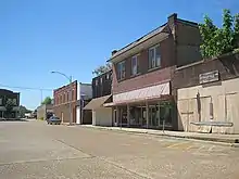 Wynne Commercial Historic District |
December 22, 2009 (#09001115) |
Roughly bounded by Front St., Commercial Ave., Terry St., Wilson St., and Pecan Ave. 35°13′23″N 90°47′30″W |
Wynne | |
| 18 | Wynne Post Office |  Wynne Post Office |
August 14, 1998 (#98000914) |
402 E. Merriman Ave. 35°13′27″N 90°47′21″W |
Wynne | |
| 19 | Wynne Wholesale Commercial Historic District | 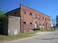 Wynne Wholesale Commercial Historic District |
January 25, 2010 (#09000772) |
Corner of W. Merriman and Martin Luther King Dr. 35°13′28″N 90°47′38″W |
Wynne |
Former listing
| [3] | Name on the Register | Image | Date listed | Date removed | Location | City or town | Summary |
|---|---|---|---|---|---|---|---|
| 1 | Missouri Pacific Depot | June 11, 1992 (#92000623) | September 17, 1999 | Southwest of the junction of N. Front St. and E. Hamilton Ave. |
Wynne |
See also
| Wikimedia Commons has media related to National Register of Historic Places in Cross County, Arkansas. |
References
- The latitude and longitude information provided in this table was derived originally from the National Register Information System, which has been found to be fairly accurate for about 99% of listings. Some locations in this table may have been corrected to current GPS standards.
- "National Register of Historic Places: Weekly List Actions". National Park Service, United States Department of the Interior. Retrieved on February 5, 2021.
- Numbers represent an alphabetical ordering by significant words. Various colorings, defined here, differentiate National Historic Landmarks and historic districts from other NRHP buildings, structures, sites or objects.
- "National Register Information System". National Register of Historic Places. National Park Service. March 13, 2009.
- The eight-digit number below each date is the number assigned to each location in the National Register Information System database, which can be viewed by clicking the number.
- Location derived from this Parkin Archeological State Park webpage; the NRIS lists the site as "Address Restricted".
| Topics | |
|---|---|
| Lists by state |
|
| Lists by insular areas | |
| Lists by associated state | |
| Other areas | |
| Related | |
| |
Municipalities and communities of Cross County, Arkansas, United States | ||
|---|---|---|
| Cities | Map of Arkansas highlighting Cross County | |
| Unincorporated communities |
| |
| Ghost towns |
| |
| Footnotes | ‡This populated place also has portions in an adjacent county or counties | |
| ||
This article is issued from Wikipedia. The text is licensed under Creative Commons - Attribution - Sharealike. Additional terms may apply for the media files.