National Register of Historic Places listings in Perry County, Arkansas
This is a list of the National Register of Historic Places listings in Perry County, Arkansas.
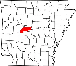
Location of Perry County in Arkansas
This is intended to be a complete list of the properties and districts on the National Register of Historic Places in Perry County, Arkansas, United States. The locations of National Register properties and districts for which the latitude and longitude coordinates are included below, may be seen in a map.[1]
There are 15 properties and districts listed on the National Register in the county.
- This National Park Service list is complete through NPS recent listings posted February 5, 2021.[2]
Current listings
| [3] | Name on the Register[4] | Image | Date listed[5] | Location | City or town | Description |
|---|---|---|---|---|---|---|
| 1 | Bigelow Methodist Episcopal Church, South | 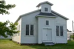 Bigelow Methodist Episcopal Church, South |
April 4, 1996 (#96000353) |
West of the junction of Volman and Emma Sts. 34°59′57″N 92°37′49″W |
Bigelow | |
| 2 | Bigelow Rosenwald School | 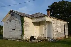 Bigelow Rosenwald School |
May 26, 2004 (#04000491) |
Junction of Highway 60 and Bethel AME Rd. 35°04′30″N 92°33′55″W |
Toad Suck | |
| 3 | Camp House | 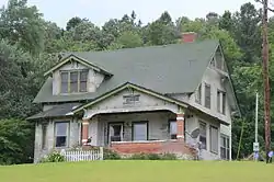 Camp House |
September 30, 2013 (#13000787) |
4684 W. AR 60 34°58′23″N 92°59′08″W |
Aplin | |
| 4 | Camp Ouachita Girl Scout Camp Historic District | 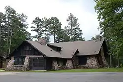 Camp Ouachita Girl Scout Camp Historic District |
February 3, 1992 (#90001826) |
Area surrounding and north of Lake Sylvia in the Ouachita National Forest 34°52′12″N 92°49′15″W |
Paron | |
| 5 | Fourche LaFave River Bridge | .jpg.webp) Fourche LaFave River Bridge |
May 26, 1995 (#95000643) |
Highway 7 over the Fourche La Fave River 34°57′07″N 93°09′08″W |
Nimrod | |
| 6 | Hawks Schoolhouse | 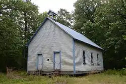 Hawks Schoolhouse |
January 28, 2002 (#01001528) |
County Road 7 34°52′06″N 93°12′30″W |
Ava | |
| 7 | Hollis Country Store | 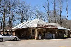 Hollis Country Store |
December 27, 2002 (#02001598) |
2125 Highway 7, S. 34°52′28″N 93°06′38″W |
Hollis | |
| 8 | Houston Methodist Episcopal Church, South | 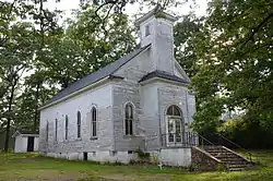 Houston Methodist Episcopal Church, South |
May 20, 1994 (#94000494) |
Southwestern side of Highway 60, near its junction with Highway 216 35°01′54″N 92°41′33″W |
Houston | |
| 9 | Perry County Courthouse | 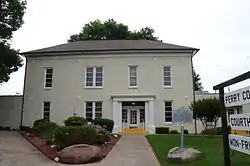 Perry County Courthouse |
July 6, 1976 (#76000443) |
Main and Pine Sts. 35°00′19″N 92°48′07″W |
Perryville | |
| 10 | Perry Rock Island Railroad Depot | January 8, 2021 (#100006027) |
8 German Rd. 35°02′56″N 92°47′43″W |
Perry | ||
| 11 | Perryville American Legion Building | 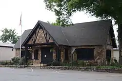 Perryville American Legion Building |
September 5, 1990 (#90001377) |
Plum and Main Sts. 35°00′18″N 92°48′12″W |
Perryville | |
| 12 | Perryville Commercial Historic District | 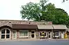 Perryville Commercial Historic District |
January 26, 2012 (#11001048) |
Roughly bounded by Arkansas Highway 10, Magnolia, Main & Plum Sts. 35°00′17″N 92°48′07″W |
Perryville | |
| 13 | C.L. Sailor House | 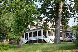 C.L. Sailor House |
July 23, 1998 (#98000880) |
Wilson St. 34°59′44″N 92°37′58″W |
Bigelow | |
| 14 | South Fourche LaFave River Bridge |  South Fourche LaFave River Bridge |
September 24, 2004 (#04001044) |
Highway 7 34°52′22″N 93°06′38″W |
Hollis | |
| 15 | Wallace Bridge | (15371).jpg.webp) Wallace Bridge |
August 1, 2008 (#08000724) |
County Road 18 34°56′11″N 93°03′19″W |
Nimrod |
Former listings
| [3] | Name on the Register | Image | Date listed | Date removed | Location | City or town | Summary |
|---|---|---|---|---|---|---|---|
| 1 | Cypress Creek Bridge | Cypress Creek Bridge |
April 9, 1990 (#90000537) | January 14, 2002 | County Road 64, over Cypress Creek |
Perry vicinity |
See also
| Wikimedia Commons has media related to National Register of Historic Places in Perry County, Arkansas. |
References
- The latitude and longitude information provided in this table was derived originally from the National Register Information System, which has been found to be fairly accurate for about 99% of listings. Some locations in this table may have been corrected to current GPS standards.
- "National Register of Historic Places: Weekly List Actions". National Park Service, United States Department of the Interior. Retrieved on February 5, 2021.
- Numbers represent an alphabetical ordering by significant words. Various colorings, defined here, differentiate National Historic Landmarks and historic districts from other NRHP buildings, structures, sites or objects.
- "National Register Information System". National Register of Historic Places. National Park Service. March 13, 2009.
- The eight-digit number below each date is the number assigned to each location in the National Register Information System database, which can be viewed by clicking the number.
| Topics | |
|---|---|
| Lists by state |
|
| Lists by insular areas | |
| Lists by associated state | |
| Other areas | |
| Related | |
| |
Municipalities and communities of Perry County, Arkansas, United States | ||
|---|---|---|
| City | Map of Arkansas highlighting Perry County | |
| Towns | ||
| Unincorporated communities | ||
| Footnotes | ‡This populated place also has portions in an adjacent county or counties | |
| ||
This article is issued from Wikipedia. The text is licensed under Creative Commons - Attribution - Sharealike. Additional terms may apply for the media files.