National Register of Historic Places listings in Greene County, Arkansas
This is a list of the National Register of Historic Places listings in Greene County, Arkansas.
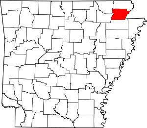
Location of Greene County in Arkansas
This is intended to be a complete list of the properties and districts on the National Register of Historic Places in Greene County, Arkansas, United States. The locations of National Register properties and districts for which the latitude and longitude coordinates are included below, may be seen in a map.[1]
There are 17 properties and districts listed on the National Register in the county.
- This National Park Service list is complete through NPS recent listings posted February 5, 2021.[2]
Current listings
| [3] | Name on the Register[4] | Image | Date listed[5] | Location | City or town | Description |
|---|---|---|---|---|---|---|
| 1 | Beisel-Mitchell House | 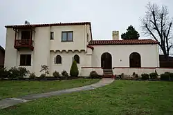 Beisel-Mitchell House |
September 27, 1996 (#96001031) |
420 W. Court St. 36°03′21″N 90°29′27″W |
Paragould | |
| 2 | Crowley's Ridge State Park-Bathhouse | 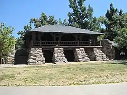 Crowley's Ridge State Park-Bathhouse |
May 28, 1992 (#92000537) |
Main service center area access road in Crowley's Ridge State Park 36°02′45″N 90°39′50″W |
Walcott | |
| 3 | Crowley's Ridge State Park-Bridge | 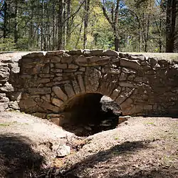 Crowley's Ridge State Park-Bridge |
May 28, 1992 (#92000540) |
Main service center area access road in Crowley's Ridge State Park 36°02′42″N 90°39′47″W |
Walcott | |
| 4 | Crowley's Ridge State Park-Comfort Station | 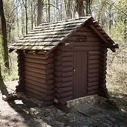 Crowley's Ridge State Park-Comfort Station |
May 28, 1992 (#92000538) |
Campground and cabin area access road in Crowley's Ridge State Park 36°02′37″N 90°39′37″W |
Walcott | |
| 5 | Crowley's Ridge State Park-Dining Hall | 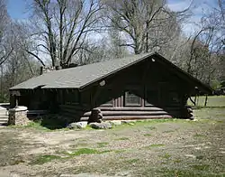 Crowley's Ridge State Park-Dining Hall |
May 28, 1992 (#92000536) |
Employee housing area access road in Crowley's Ridge State Park 36°02′59″N 90°39′48″W |
Walcott | |
| 6 | George Ray's Dragstrip |  George Ray's Dragstrip |
February 21, 2006 (#06000075) |
Highway 135, 0.5 miles south of U.S. Route 412 36°02′50″N 90°26′04″W |
Paragould | |
| 7 | Greene County Courthouse | 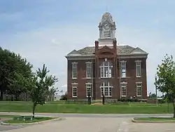 Greene County Courthouse |
August 11, 1976 (#76000412) |
Court Sq. 36°03′14″N 90°29′12″W |
Paragould | |
| 8 | Gulf Oil Company Service Station |  Gulf Oil Company Service Station |
August 16, 1994 (#94000850) |
Southeastern corner of the junction of Main and S. 3rd Sts. 36°03′15″N 90°29′17″W |
Paragould | |
| 9 | Highfill-McClure House | 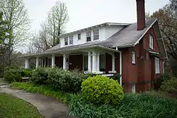 Highfill-McClure House |
March 28, 2002 (#02000260) |
701 W. Highland St. 36°03′28″N 90°29′40″W |
Paragould | |
| 10 | Jackson-Herget House | 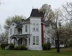 Jackson-Herget House |
July 24, 1992 (#92000907) |
206 S. 4th St. 36°03′18″N 90°29′26″W |
Paragould | |
| 11 | Linwood Mausoleum | 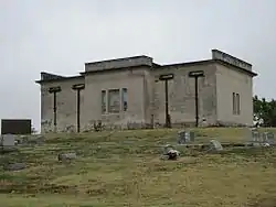 Linwood Mausoleum |
January 29, 2007 (#06001314) |
Junction of W. Kingshighway and Linwood Dr. 36°03′04″N 90°30′11″W |
Paragould | |
| 12 | National Bank of Commerce Building | 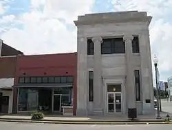 National Bank of Commerce Building |
May 14, 1993 (#93000423) |
200 S. Pruett St. 36°03′19″N 90°29′11″W |
Paragould | |
| 13 | Old Bethel Methodist Church | 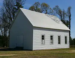 Old Bethel Methodist Church |
April 19, 1978 (#78000590) |
West of Paragould off Highway 141 36°00′46″N 90°39′30″W |
Paragould | |
| 14 | Paragould Downtown Commercial Historic District | 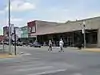 Paragould Downtown Commercial Historic District |
July 18, 2003 (#03000646) |
Roughly bounded by 3rd Ave., Kings Highway, 3½ St., and W. Highland St. 36°03′19″N 90°29′13″W |
Paragould | |
| 15 | Paragould War Memorial | 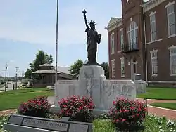 Paragould War Memorial |
June 20, 1997 (#97000554) |
Junction of 3rd and Court Sts. 36°03′21″N 90°29′20″W |
Paragould | |
| 16 | St. Mary's Catholic Church | 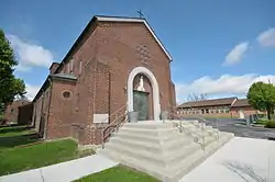 St. Mary's Catholic Church |
January 27, 2015 (#14001198) |
301 W. Highland 36°03′30″N 90°29′16″W |
Paragould | |
| 17 | Texaco Station No. 1 |  Texaco Station No. 1 |
July 20, 2001 (#01000718) |
110 E. Main St. 36°03′16″N 90°29′09″W |
Paragould |
Former listings
| [3] | Name on the Register | Image | Date listed | Date removed | Location | City or town | Summary |
|---|---|---|---|---|---|---|---|
| 1 | Big Slough Ditch Bridge | June 9, 2000 (#00000629) | September 24, 2004 | County Road 855 |
Brighton vicinity | ||
| 2 | Eight Mile Creek Bridge | 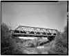 Eight Mile Creek Bridge |
1990 (#90000524) | September 24, 2004 | AR 135 |
Paragould vicinity |
See also
| Wikimedia Commons has media related to National Register of Historic Places in Greene County, Arkansas. |
References
- The latitude and longitude information provided in this table was derived originally from the National Register Information System, which has been found to be fairly accurate for about 99% of listings. Some locations in this table may have been corrected to current GPS standards.
- "National Register of Historic Places: Weekly List Actions". National Park Service, United States Department of the Interior. Retrieved on February 5, 2021.
- Numbers represent an alphabetical ordering by significant words. Various colorings, defined here, differentiate National Historic Landmarks and historic districts from other NRHP buildings, structures, sites or objects.
- "National Register Information System". National Register of Historic Places. National Park Service. March 13, 2009.
- The eight-digit number below each date is the number assigned to each location in the National Register Information System database, which can be viewed by clicking the number.
| Topics | |
|---|---|
| Lists by state |
|
| Lists by insular areas | |
| Lists by associated state | |
| Other areas | |
| Related | |
| |
Municipalities and communities of Greene County, Arkansas, United States | ||
|---|---|---|
| Cities | Map of Arkansas highlighting Greene County | |
| Towns | ||
| Unincorporated communities | ||
| ||
This article is issued from Wikipedia. The text is licensed under Creative Commons - Attribution - Sharealike. Additional terms may apply for the media files.