National Register of Historic Places listings in Newton County, Arkansas
This is a list of the National Register of Historic Places listings in Newton County, Arkansas.
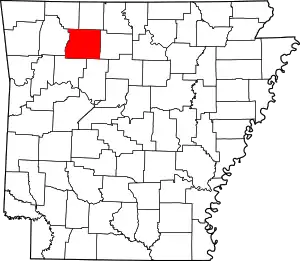
Location of Newton County in Arkansas
This is intended to be a complete list of the properties and districts on the National Register of Historic Places in Newton County, Arkansas, United States. The locations of National Register properties and districts for which the latitude and longitude coordinates are included below, may be seen in a map.[1]
There are 14 properties and districts listed on the National Register in the county.
- This National Park Service list is complete through NPS recent listings posted January 29, 2021.[2]
Current listings
| [3] | Name on the Register[4] | Image | Date listed[5] | Location | City or town | Description |
|---|---|---|---|---|---|---|
| 1 | Archeological Site 3NW79 | May 23, 2007 (#07000202) |
Address Restricted |
Cowell | ||
| 2 | Big Buffalo Valley Historic District | 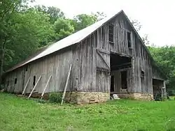 Big Buffalo Valley Historic District |
July 29, 1987 (#87000110) |
Buffalo National River 35°59′56″N 93°23′29″W |
Ponca | |
| 3 | Buffalo River Bridge |  Buffalo River Bridge |
April 9, 1990 (#90000509) |
Highway 7, over the Buffalo River 36°03′38″N 93°08′18″W |
Pruitt | |
| 4 | Dr. Hudson Sanitarium Agricultural Building Historic District | October 8, 1992 (#92001345) |
Highway 327, south of its junction with Highway 74 35°59′42″N 93°12′12″W |
Jasper | ||
| 5 | Flowers Cabin |  Flowers Cabin |
January 6, 2021 (#100005991) |
Buffalo National River, Bench Trail, approx. .2 mi. east of the Hemmed In Hollow Trail, south of the Compton Trailhead 36°04′30″N 93°12′12″W |
Compton vicinity | |
| 6 | Harp Creek Bridge | .jpg.webp) Harp Creek Bridge |
April 9, 1990 (#90000519) |
Highway 7 over Harp Creek 36°04′58″N 93°08′14″W |
Jasper | |
| 7 | Jasper Commercial Historic District | 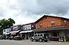 Jasper Commercial Historic District |
January 21, 2010 (#09001255) |
Roughly bounded by Sycamore St., E. Elm St., N. Spring St., and Clark St. 36°00′29″N 93°11′14″W |
Jasper | |
| 8 | Gould Jones Reservoir |  Gould Jones Reservoir |
August 24, 1998 (#98000956) |
Highway 7 just south of Jasper 36°00′12″N 93°11′07″W |
Jasper | |
| 9 | Little Buffalo River Bridge | 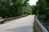 Little Buffalo River Bridge |
May 26, 1995 (#95000647) |
Highway 327 over the Little Buffalo River 35°58′07″N 93°13′37″W |
Parthenon | |
| 10 | May Farmstead | December 9, 1999 (#99001470) |
3 miles northeast of Bass on Cave Creek 35°56′15″N 92°58′36″W |
Bass | ||
| 11 | Newton County Courthouse |  Newton County Courthouse |
December 1, 1994 (#94001412) |
Courthouse Sq. 36°00′29″N 93°11′13″W |
Jasper | |
| 12 | Newton County Jail | 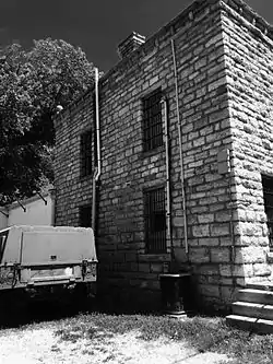 Newton County Jail |
December 1, 1994 (#94001414) |
Junction of Spring and Elm Sts. 36°00′31″N 93°11′12″W |
Jasper | |
| 13 | Parker-Hickman Farm Historic District |  Parker-Hickman Farm Historic District |
August 11, 1987 (#87001029) |
Buffalo National River 36°04′16″N 93°13′18″W |
Erbie | |
| 14 | Villines Mill |  Villines Mill |
July 31, 1974 (#74000482) |
North of Boxley on Highway 43 35°59′18″N 93°23′58″W |
Boxley |
Former listings
| [3] | Name on the Register | Image | Date listed | Date removed | Location | City or town | Summary |
|---|---|---|---|---|---|---|---|
| 1 | Newton County Academy | January 18, 1979 (#79000447) | June 3, 1986 | Gum Springs Rd. |
Parthenon |
See also
| Wikimedia Commons has media related to National Register of Historic Places in Newton County, Arkansas. |
References
- The latitude and longitude information provided in this table was derived originally from the National Register Information System, which has been found to be fairly accurate for about 99% of listings. Some locations in this table may have been corrected to current GPS standards.
- "National Register of Historic Places: Weekly List Actions". National Park Service, United States Department of the Interior. Retrieved on January 29, 2021.
- Numbers represent an alphabetical ordering by significant words. Various colorings, defined here, differentiate National Historic Landmarks and historic districts from other NRHP buildings, structures, sites or objects.
- "National Register Information System". National Register of Historic Places. National Park Service. March 13, 2009.
- The eight-digit number below each date is the number assigned to each location in the National Register Information System database, which can be viewed by clicking the number.
| Topics | |
|---|---|
| Lists by state |
|
| Lists by insular areas | |
| Lists by associated state | |
| Other areas | |
| Related | |
| |
Municipalities and communities of Newton County, Arkansas, United States | ||
|---|---|---|
| City | Map of Arkansas highlighting Newton County | |
| Town | ||
| Townships |
| |
| Unincorporated communities | ||
| ||
This article is issued from Wikipedia. The text is licensed under Creative Commons - Attribution - Sharealike. Additional terms may apply for the media files.