Blandin
Blandin is a commune in the Isère department in southeastern France. Its inhabitants are known as Blandinois.[2]
Blandin | |
|---|---|
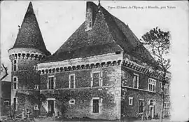 Chateau Épinay in Blandin | |
Location of Blandin 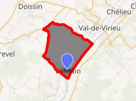
| |
 Blandin  Blandin | |
| Coordinates: 45°28′15″N 5°26′53″E | |
| Country | France |
| Region | Auvergne-Rhône-Alpes |
| Department | Isère |
| Arrondissement | La Tour-du-Pin |
| Canton | Le Grand-Lemps |
| Government | |
| • Mayor (2008–2014) | Corinne Magnien |
| Area 1 | 4.26 km2 (1.64 sq mi) |
| Population (2017-01-01)[1] | 145 |
| • Density | 34/km2 (88/sq mi) |
| Time zone | UTC+01:00 (CET) |
| • Summer (DST) | UTC+02:00 (CEST) |
| INSEE/Postal code | 38047 /38730 |
| Elevation | 387–664 m (1,270–2,178 ft) (avg. 410 m or 1,350 ft) |
| 1 French Land Register data, which excludes lakes, ponds, glaciers > 1 km2 (0.386 sq mi or 247 acres) and river estuaries. | |
Geography
Blandin was erected in 1801. Blandin is located 25 km from Voiron, 14 km from the Tour du Pin. The Bourbre forms the commune's eastern border.
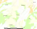 Map of the Commune
Population
In 2017, the municipality had 145 inhabitants.
|
| |||||||||||||||||||||||||||||||||||||||||||||||||||||||||||||||||||||||||||||||||||||||||||||||||||||||||||||||
| Source: EHESS[3] and INSEE (1968-2017)[4] | ||||||||||||||||||||||||||||||||||||||||||||||||||||||||||||||||||||||||||||||||||||||||||||||||||||||||||||||||
See also
References
- "Populations légales 2017". INSEE. Retrieved 6 January 2020.
- "Le nom des habitants du 38 - Isère". habitants.fr (in French). Retrieved 2020-03-08.
- Données Cassini, EHESS
- Population en historique depuis 1968, INSEE
| Wikimedia Commons has media related to Blandin. |
| Authority control |
|---|
This article is issued from Wikipedia. The text is licensed under Creative Commons - Attribution - Sharealike. Additional terms may apply for the media files.