Saint-Hilaire-de-la-Côte
Saint-Hilaire-de-la-Côte is a commune in the Isère department in southeastern France.
Saint-Hilaire-de-la-Côte | |
|---|---|
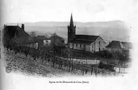 Saint-Hilaire-de-la-Cote in 1904 | |
Location of Saint-Hilaire-de-la-Côte 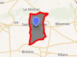
| |
 Saint-Hilaire-de-la-Côte  Saint-Hilaire-de-la-Côte | |
| Coordinates: 45°23′29″N 5°19′41″E | |
| Country | France |
| Region | Auvergne-Rhône-Alpes |
| Department | Isère |
| Arrondissement | Vienne |
| Canton | Bièvre |
| Government | |
| • Mayor (2020–2026) | Hubert Farnoux |
| Area 1 | 13.75 km2 (5.31 sq mi) |
| Population (2017-01-01)[1] | 1,504 |
| • Density | 110/km2 (280/sq mi) |
| Time zone | UTC+01:00 (CET) |
| • Summer (DST) | UTC+02:00 (CEST) |
| INSEE/Postal code | 38393 /38260 |
| Elevation | 361–647 m (1,184–2,123 ft) (avg. 400 m or 1,300 ft) |
| 1 French Land Register data, which excludes lakes, ponds, glaciers > 1 km2 (0.386 sq mi or 247 acres) and river estuaries. | |
Population
| Year | Pop. | ±% |
|---|---|---|
| 1793 | 1,012 | — |
| 1806 | 981 | −3.1% |
| 1821 | 1,044 | +6.4% |
| 1831 | 1,259 | +20.6% |
| 1841 | 1,231 | −2.2% |
| 1851 | 1,233 | +0.2% |
| 1861 | 1,130 | −8.4% |
| 1872 | 1,094 | −3.2% |
| 1881 | 1,119 | +2.3% |
| 1891 | 1,021 | −8.8% |
| 1901 | 921 | −9.8% |
| 1911 | 823 | −10.6% |
| 1921 | 728 | −11.5% |
| 1931 | 682 | −6.3% |
| 1946 | 619 | −9.2% |
| 1954 | 607 | −1.9% |
| 1962 | 593 | −2.3% |
| 1968 | 564 | −4.9% |
| 1975 | 531 | −5.9% |
| 1982 | 802 | +51.0% |
| 1990 | 1,001 | +24.8% |
| 1999 | 1,106 | +10.5% |
| 2006 | 1,317 | +19.1% |
| 2007 | 1,348 | +2.4% |
| 2008 | 1,378 | +2.2% |
| 2013 | 1,416 | +2.8% |
| 2017 | 1,504 | +6.2% |
See also
References
| Wikimedia Commons has media related to Saint-Hilaire-de-la-Côte. |
- "Populations légales 2017". INSEE. Retrieved 6 January 2020.
| Authority control |
|---|
This article is issued from Wikipedia. The text is licensed under Creative Commons - Attribution - Sharealike. Additional terms may apply for the media files.