Saint-Didier-de-Bizonnes
Saint-Didier-de-Bizonnes is a commune in the Isère department in southeastern France.
Saint-Didier-de-Bizonnes | |
|---|---|
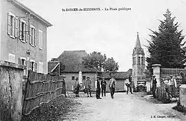 Saint-Didier-de-Bizonnes at the start of the 20th century | |
Location of Saint-Didier-de-Bizonnes 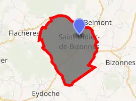
| |
 Saint-Didier-de-Bizonnes  Saint-Didier-de-Bizonnes | |
| Coordinates: 45°28′05″N 5°21′06″E | |
| Country | France |
| Region | Auvergne-Rhône-Alpes |
| Department | Isère |
| Arrondissement | La Tour-du-Pin |
| Canton | Le Grand-Lemps |
| Intercommunality | Bièvre Est |
| Government | |
| • Mayor (2014–2020) | Joëlle Anglereaux |
| Area 1 | 7.2 km2 (2.8 sq mi) |
| Population (2017-01-01)[1] | 302 |
| • Density | 42/km2 (110/sq mi) |
| Time zone | UTC+01:00 (CET) |
| • Summer (DST) | UTC+02:00 (CEST) |
| INSEE/Postal code | 38380 /38690 |
| Elevation | 514–647 m (1,686–2,123 ft) (avg. 530 m or 1,740 ft) |
| 1 French Land Register data, which excludes lakes, ponds, glaciers > 1 km2 (0.386 sq mi or 247 acres) and river estuaries. | |
Population
| Year | Pop. | ±% |
|---|---|---|
| 1793 | 356 | — |
| 1806 | 438 | +23.0% |
| 1821 | 368 | −16.0% |
| 1831 | 526 | +42.9% |
| 1841 | 468 | −11.0% |
| 1851 | 499 | +6.6% |
| 1861 | 422 | −15.4% |
| 1872 | 368 | −12.8% |
| 1881 | 341 | −7.3% |
| 1891 | 340 | −0.3% |
| 1901 | 299 | −12.1% |
| 1911 | 249 | −16.7% |
| 1921 | 242 | −2.8% |
| 1931 | 225 | −7.0% |
| 1946 | 203 | −9.8% |
| 1954 | 213 | +4.9% |
| 1962 | 208 | −2.3% |
| 1968 | 181 | −13.0% |
| 1975 | 170 | −6.1% |
| 1982 | 147 | −13.5% |
| 1990 | 175 | +19.0% |
| 1999 | 208 | +18.9% |
| 2006 | 240 | +15.4% |
| 2011 | 294 | +22.5% |
See also
References
| Wikimedia Commons has media related to Saint-Didier-de-Bizonnes. |
- "Populations légales 2017". INSEE. Retrieved 6 January 2020.
| Authority control |
|---|
This article is issued from Wikipedia. The text is licensed under Creative Commons - Attribution - Sharealike. Additional terms may apply for the media files.