Les Éparres
Les Éparres is a commune in the Isère department in southeastern France.
Les Éparres | |
|---|---|
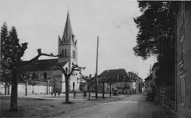 Les Éparres at the start of the 20th century | |
Location of Les Éparres 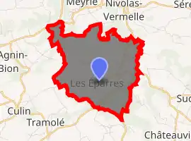
| |
 Les Éparres  Les Éparres | |
| Coordinates: 45°32′03″N 5°17′37″E | |
| Country | France |
| Region | Auvergne-Rhône-Alpes |
| Department | Isère |
| Arrondissement | La Tour-du-Pin |
| Canton | Bourgoin-Jallieu |
| Intercommunality | Porte de l'Isère |
| Government | |
| • Mayor (2014–2020) | Bernard Marmonier |
| Area 1 | 7.95 km2 (3.07 sq mi) |
| Population (2017-01-01)[1] | 985 |
| • Density | 120/km2 (320/sq mi) |
| Time zone | UTC+01:00 (CET) |
| • Summer (DST) | UTC+02:00 (CEST) |
| INSEE/Postal code | 38156 /38300 |
| Elevation | 319–501 m (1,047–1,644 ft) (avg. 428 m or 1,404 ft) |
| 1 French Land Register data, which excludes lakes, ponds, glaciers > 1 km2 (0.386 sq mi or 247 acres) and river estuaries. | |
Population
| Year | Pop. | ±% |
|---|---|---|
| 1793 | 1,057 | — |
| 1806 | 1,621 | +53.4% |
| 1821 | 1,480 | −8.7% |
| 1831 | 1,675 | +13.2% |
| 1841 | 1,500 | −10.4% |
| 1851 | 1,568 | +4.5% |
| 1861 | 1,074 | −31.5% |
| 1872 | 1,015 | −5.5% |
| 1881 | 784 | −22.8% |
| 1891 | 827 | +5.5% |
| 1901 | 905 | +9.4% |
| 1911 | 821 | −9.3% |
| 1921 | 718 | −12.5% |
| 1931 | 684 | −4.7% |
| 1946 | 546 | −20.2% |
| 1854 | 596 | +9.2% |
| 1962 | 618 | +3.7% |
| 1968 | 731 | +18.3% |
| 1975 | 752 | +2.9% |
| 1982 | 707 | −6.0% |
| 1990 | 860 | +21.6% |
| 1999 | 916 | +6.5% |
| 2009 | 921 | +0.5% |
| 2011 | 899 | −2.4% |
See also
References
- "Populations légales 2017". INSEE. Retrieved 6 January 2020.
| Wikimedia Commons has media related to Les Éparres. |
| Authority control |
|---|
This article is issued from Wikipedia. The text is licensed under Creative Commons - Attribution - Sharealike. Additional terms may apply for the media files.