Villefontaine
Villefontaine is a commune in the Isère department in southeastern France.
Villefontaine | |
|---|---|
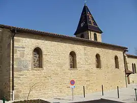
 The church of Villefontaine | |
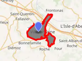
Location of Villefontaine 
| |
 Villefontaine  Villefontaine | |
| Coordinates: 45°36′51″N 5°08′58″E | |
| Country | France |
| Region | Auvergne-Rhône-Alpes |
| Department | Isère |
| Arrondissement | La Tour-du-Pin |
| Canton | L'Isle-d'Abeau |
| Intercommunality | CA Porte de l'Isère |
| Government | |
| • Mayor (2014–2020) | Raymond Feyssaguet (DVD) |
| Area 1 | 11.63 km2 (4.49 sq mi) |
| Population (2017-01-01)[1] | 18,763 |
| • Density | 1,600/km2 (4,200/sq mi) |
| Time zone | UTC+01:00 (CET) |
| • Summer (DST) | UTC+02:00 (CEST) |
| INSEE/Postal code | 38553 /38090 |
| Elevation | 208–352 m (682–1,155 ft) |
| 1 French Land Register data, which excludes lakes, ponds, glaciers > 1 km2 (0.386 sq mi or 247 acres) and river estuaries. | |
Geography
The Bourbre flows northwest through the northeastern part of the commune.
Population
| Year | Pop. | ±% |
|---|---|---|
| 1793 | 345 | — |
| 1806 | 322 | −6.7% |
| 1821 | 509 | +58.1% |
| 1831 | 503 | −1.2% |
| 1841 | 519 | +3.2% |
| 1851 | 541 | +4.2% |
| 1861 | 462 | −14.6% |
| 1872 | 451 | −2.4% |
| 1881 | 409 | −9.3% |
| 1891 | 408 | −0.2% |
| 1901 | 414 | +1.5% |
| 1911 | 345 | −16.7% |
| 1921 | 432 | +25.2% |
| 1931 | 509 | +17.8% |
| 1946 | 395 | −22.4% |
| 1954 | 398 | +0.8% |
| 1962 | 467 | +17.3% |
| 1968 | 452 | −3.2% |
| 1975 | 1,694 | +274.8% |
| 1982 | 9,719 | +473.7% |
| 1990 | 16,171 | +66.4% |
| 1999 | 17,766 | +9.9% |
| 2006 | 18,407 | +3.6% |
| 2012 | 18,009 | −2.2% |
Twin towns
Villefontaine is twinned with:
 Kahl am Main, Germany, since 1980
 Bitterfeld-Wolfen, Germany, since 1994
 Gremda, Tunisia, since 1994
 Salzano, Italy, since 2009
See also
This article is issued from Wikipedia. The text is licensed under Creative Commons - Attribution - Sharealike. Additional terms may apply for the media files.