Bougé-Chambalud
Bougé-Chambalud is a commune in the Isère department in southeastern France.
Bougé-Chambalud | |
|---|---|
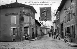 The town hall square and main road in 1919 | |
Location of Bougé-Chambalud 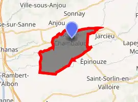
| |
 Bougé-Chambalud  Bougé-Chambalud | |
| Coordinates: 45°19′52″N 4°54′08″E | |
| Country | France |
| Region | Auvergne-Rhône-Alpes |
| Department | Isère |
| Arrondissement | Vienne |
| Canton | Roussillon |
| Intercommunality | Pays Roussillonnais |
| Government | |
| • Mayor (2008–2014) | Gerard Forcheron |
| Area 1 | 15.85 km2 (6.12 sq mi) |
| Population (2017-01-01)[1] | 1,375 |
| • Density | 87/km2 (220/sq mi) |
| Time zone | UTC+01:00 (CET) |
| • Summer (DST) | UTC+02:00 (CEST) |
| INSEE/Postal code | 38051 /38150 |
| Elevation | 172–232 m (564–761 ft) (avg. 220 m or 720 ft) |
| 1 French Land Register data, which excludes lakes, ponds, glaciers > 1 km2 (0.386 sq mi or 247 acres) and river estuaries. | |
Population
| Year | Pop. | ±% |
|---|---|---|
| 1801 | 665 | — |
| 1810 | 653 | −1.8% |
| 1820 | 727 | +11.3% |
| 1831 | 935 | +28.6% |
| 1841 | 1,149 | +22.9% |
| 1851 | 1,169 | +1.7% |
| 1861 | 1,211 | +3.6% |
| 1872 | 1,126 | −7.0% |
| 1881 | 1,068 | −5.2% |
| 1891 | 1,011 | −5.3% |
| 1901 | 901 | −10.9% |
| 1911 | 891 | −1.1% |
| 1931 | 790 | −11.3% |
| 1946 | 776 | −1.8% |
| 1954 | 817 | +5.3% |
| 1958 | 806 | −1.3% |
| 1962 | 743 | −7.8% |
| 1968 | 789 | +6.2% |
| 1975 | 717 | −9.1% |
| 1982 | 672 | −6.3% |
| 1990 | 814 | +21.1% |
| 1999 | 918 | +12.8% |
| 2005 | 1,131 | +23.2% |
| 2009 | 1,240 | +9.6% |
See also
References
- "Populations légales 2017". INSEE. Retrieved 6 January 2020.
| Wikimedia Commons has media related to Bougé-Chambalud. |
| Authority control |
|
|---|
This article is issued from Wikipedia. The text is licensed under Creative Commons - Attribution - Sharealike. Additional terms may apply for the media files.