Saint-Hilaire-du-Rosier
Saint-Hilaire-du-Rosier is a commune in the Isère department in southeastern France.
Saint-Hilaire-du-Rosier | |
|---|---|
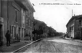 Saint-Hilaire-du-Rosier around 1930 | |
Location of Saint-Hilaire-du-Rosier 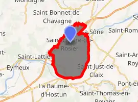
| |
 Saint-Hilaire-du-Rosier  Saint-Hilaire-du-Rosier | |
| Coordinates: 45°05′55″N 5°15′06″E | |
| Country | France |
| Region | Auvergne-Rhône-Alpes |
| Department | Isère |
| Arrondissement | Grenoble |
| Canton | Le Sud Grésivaudan |
| Intercommunality | Pays de Saint-Marcellin |
| Government | |
| • Mayor (2014–2020) | Olivier Feugier |
| Area 1 | 16.42 km2 (6.34 sq mi) |
| Population (2017-01-01)[1] | 1,886 |
| • Density | 110/km2 (300/sq mi) |
| Time zone | UTC+01:00 (CET) |
| • Summer (DST) | UTC+02:00 (CEST) |
| INSEE/Postal code | 38394 /38840 |
| Elevation | 151–280 m (495–919 ft) |
| 1 French Land Register data, which excludes lakes, ponds, glaciers > 1 km2 (0.386 sq mi or 247 acres) and river estuaries. | |
Population
| Year | Pop. | ±% |
|---|---|---|
| 1793 | 735 | — |
| 1806 | 771 | +4.9% |
| 1821 | 903 | +17.1% |
| 1831 | 1,015 | +12.4% |
| 1941 | 1,017 | +0.2% |
| 1851 | 1,119 | +10.0% |
| 1861 | 1,078 | −3.7% |
| 1872 | 1,003 | −7.0% |
| 1881 | 922 | −8.1% |
| 1891 | 951 | +3.1% |
| 1901 | 969 | +1.9% |
| 1911 | 976 | +0.7% |
| 1921 | 944 | −3.3% |
| 1931 | 1,053 | +11.5% |
| 1946 | 989 | −6.1% |
| 1954 | 1,155 | +16.8% |
| 1962 | 1,345 | +16.5% |
| 1968 | 1,279 | −4.9% |
| 1975 | 1,324 | +3.5% |
| 1982 | 1,559 | +17.7% |
| 1990 | 1,731 | +11.0% |
| 1999 | 1,760 | +1.7% |
| 2006 | 1,846 | +4.9% |
| 2011 | 1,967 | +6.6% |
See also
References
| Wikimedia Commons has media related to Saint-Hilaire-du-Rosier. |
- "Populations légales 2017". INSEE. Retrieved 6 January 2020.
| Authority control |
|---|
This article is issued from Wikipedia. The text is licensed under Creative Commons - Attribution - Sharealike. Additional terms may apply for the media files.