Saint-Romans
Saint-Romans is a commune in the Isère department in southeastern France.
Saint-Romans | |
|---|---|
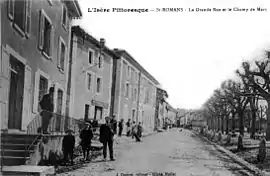 Saint-Romans in 1910 | |
 Coat of arms | |
Location of Saint-Romans 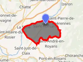
| |
 Saint-Romans  Saint-Romans | |
| Coordinates: 45°07′00″N 5°19′39″E | |
| Country | France |
| Region | Auvergne-Rhône-Alpes |
| Department | Isère |
| Arrondissement | Grenoble |
| Canton | Le Sud Grésivaudan |
| Intercommunality | Bourne à l'Isère |
| Government | |
| • Mayor (2014–2020) | Yvan Créach |
| Area 1 | 17.04 km2 (6.58 sq mi) |
| Population (2017-01-01)[1] | 1,778 |
| • Density | 100/km2 (270/sq mi) |
| Time zone | UTC+01:00 (CET) |
| • Summer (DST) | UTC+02:00 (CEST) |
| INSEE/Postal code | 38453 /38160 |
| Elevation | 160–863 m (525–2,831 ft) (avg. 218 m or 715 ft) |
| 1 French Land Register data, which excludes lakes, ponds, glaciers > 1 km2 (0.386 sq mi or 247 acres) and river estuaries. | |
Population
| Year | Pop. | ±% |
|---|---|---|
| 1793 | 853 | — |
| 1806 | 850 | −0.4% |
| 1821 | 1,047 | +23.2% |
| 1831 | 1,009 | −3.6% |
| 1841 | 1,142 | +13.2% |
| 1851 | 1,227 | +7.4% |
| 1861 | 1,225 | −0.2% |
| 1872 | 1,117 | −8.8% |
| 1881 | 1,060 | −5.1% |
| 1891 | 1,082 | +2.1% |
| 1901 | 1,136 | +5.0% |
| 1911 | 981 | −13.6% |
| 1921 | 907 | −7.5% |
| 1931 | 924 | +1.9% |
| 1946 | 886 | −4.1% |
| 1954 | 845 | −4.6% |
| 1962 | 941 | +11.4% |
| 1968 | 1,001 | +6.4% |
| 1975 | 1,129 | +12.8% |
| 1982 | 1,306 | +15.7% |
| 1990 | 1,367 | +4.7% |
| 1999 | 1,410 | +3.1% |
| 2006 | 1,652 | +17.2% |
| 2011 | 1,739 | +5.3% |
References
- "Populations légales 2017". INSEE. Retrieved 6 January 2020.
| Wikimedia Commons has media related to Saint-Romans. |
| Authority control |
|---|
This article is issued from Wikipedia. The text is licensed under Creative Commons - Attribution - Sharealike. Additional terms may apply for the media files.