Sainte-Blandine, Isère
Sainte-Blandine is a commune in the Isère department in southeastern France.
Sainte-Blandine | |
|---|---|
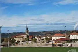 The village centre of Sainte-Blandine | |
Location of Sainte-Blandine 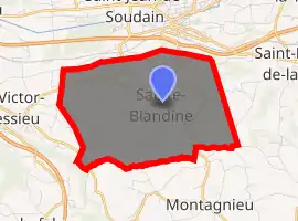
| |
 Sainte-Blandine  Sainte-Blandine | |
| Coordinates: 45°32′51″N 5°26′28″E | |
| Country | France |
| Region | Auvergne-Rhône-Alpes |
| Department | Isère |
| Arrondissement | La Tour-du-Pin |
| Canton | La Tour-du-Pin |
| Government | |
| • Mayor (2014–2020) | Jacques Garnier |
| Area 1 | 9.21 km2 (3.56 sq mi) |
| Population (2017-01-01)[1] | 977 |
| • Density | 110/km2 (270/sq mi) |
| Time zone | UTC+01:00 (CET) |
| • Summer (DST) | UTC+02:00 (CEST) |
| INSEE/Postal code | 38369 /38110 |
| Elevation | 328–493 m (1,076–1,617 ft) |
| 1 French Land Register data, which excludes lakes, ponds, glaciers > 1 km2 (0.386 sq mi or 247 acres) and river estuaries. | |
Population
| Year | Pop. | ±% |
|---|---|---|
| 1793 | 716 | — |
| 1806 | 671 | −6.3% |
| 1821 | 706 | +5.2% |
| 1831 | 773 | +9.5% |
| 1841 | 801 | +3.6% |
| 1851 | 906 | +13.1% |
| 1861 | 541 | −40.3% |
| 1872 | 807 | +49.2% |
| 1881 | 795 | −1.5% |
| 1891 | 736 | −7.4% |
| 1901 | 674 | −8.4% |
| 1911 | 626 | −7.1% |
| 1921 | 604 | −3.5% |
| 1931 | 600 | −0.7% |
| 1946 | 571 | −4.8% |
| 1954 | 576 | +0.9% |
| 1962 | 587 | +1.9% |
| 1968 | 491 | −16.4% |
| 1975 | 482 | −1.8% |
| 1982 | 666 | +38.2% |
| 1990 | 747 | +12.2% |
| 1999 | 764 | +2.3% |
| 2006 | 892 | +16.8% |
| 2011 | 911 | +2.1% |
See also
References
| Wikimedia Commons has media related to Sainte-Blandine (Isère). |
- "Populations légales 2017". INSEE. Retrieved 6 January 2020.
| Authority control |
|---|
This article is issued from Wikipedia. The text is licensed under Creative Commons - Attribution - Sharealike. Additional terms may apply for the media files.