Les Roches-de-Condrieu
Les Roches-de-Condrieu is a commune in the Isère department in southeastern France.
Les Roches-de-Condrieu | |
|---|---|
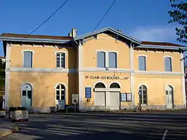 Train station | |
 Coat of arms | |
Location of Les Roches-de-Condrieu 
| |
 Les Roches-de-Condrieu  Les Roches-de-Condrieu | |
| Coordinates: 45°27′14″N 4°46′07″E | |
| Country | France |
| Region | Auvergne-Rhône-Alpes |
| Department | Isère |
| Arrondissement | Vienne |
| Canton | Vienne-2 |
| Government | |
| • Mayor (2014–2020) | Isabelle Dugua |
| Area 1 | 1.03 km2 (0.40 sq mi) |
| Population (2017-01-01)[1] | 1,925 |
| • Density | 1,900/km2 (4,800/sq mi) |
| Time zone | UTC+01:00 (CET) |
| • Summer (DST) | UTC+02:00 (CEST) |
| INSEE/Postal code | 38340 /38370 |
| Elevation | 155–200 m (509–656 ft) (avg. 157 m or 515 ft) |
| 1 French Land Register data, which excludes lakes, ponds, glaciers > 1 km2 (0.386 sq mi or 247 acres) and river estuaries. | |
Population
| Year | Pop. | ±% |
|---|---|---|
| 1793 | 1,481 | — |
| 1806 | 1,532 | +3.4% |
| 1821 | 1,436 | −6.3% |
| 1831 | 1,458 | +1.5% |
| 1841 | 1,429 | −2.0% |
| 1851 | 1,358 | −5.0% |
| 1861 | 1,217 | −10.4% |
| 1872 | 1,054 | −13.4% |
| 1881 | 873 | −17.2% |
| 1891 | 876 | +0.3% |
| 1901 | 940 | +7.3% |
| 1911 | 812 | −13.6% |
| 1921 | 868 | +6.9% |
| 1931 | 1,051 | +21.1% |
| 1946 | 1,132 | +7.7% |
| 19954 | 1,239 | +9.5% |
| 1962 | 1,297 | +4.7% |
| 1968 | 1,534 | +18.3% |
| 1975 | 1,576 | +2.7% |
| 1982 | 1,728 | +9.6% |
| 1990 | 1,836 | +6.2% |
| 1999 | 1,819 | −0.9% |
| 2006 | 1,912 | +5.1% |
| 2011 | 1,976 | +3.3% |
See also
References
- "Populations légales 2017". INSEE. Retrieved 6 January 2020.
| Wikimedia Commons has media related to Les Roches-de-Condrieu. |
| Authority control |
|---|
This article is issued from Wikipedia. The text is licensed under Creative Commons - Attribution - Sharealike. Additional terms may apply for the media files.