Sérézin-de-la-Tour
Sérézin-de-la-Tour is a commune in the Isère department in southeastern France.
Sérézin-de-la-Tour | |
|---|---|
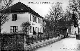 Sérezin-la Tour town hall in 1908 | |
Location of Sérézin-de-la-Tour 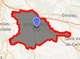
| |
 Sérézin-de-la-Tour  Sérézin-de-la-Tour | |
| Coordinates: 45°33′30″N 5°20′42″E | |
| Country | France |
| Region | Auvergne-Rhône-Alpes |
| Department | Isère |
| Arrondissement | La Tour-du-Pin |
| Canton | Bourgoin-Jallieu |
| Intercommunality | Porte de l'Isère |
| Government | |
| • Mayor (2014–2020) | Olivier Chanel |
| Area 1 | 9.31 km2 (3.59 sq mi) |
| Population (2017-01-01)[1] | 1,057 |
| • Density | 110/km2 (290/sq mi) |
| Time zone | UTC+01:00 (CET) |
| • Summer (DST) | UTC+02:00 (CEST) |
| INSEE/Postal code | 38481 /38300 |
| Elevation | 266–466 m (873–1,529 ft) (avg. 318 m or 1,043 ft) |
| 1 French Land Register data, which excludes lakes, ponds, glaciers > 1 km2 (0.386 sq mi or 247 acres) and river estuaries. | |
Geography
The Bourbre forms part of the commune's northern border.
Population
| Year | Pop. | ±% |
|---|---|---|
| 1793 | 2,504 | — |
| 1806 | 1,077 | −57.0% |
| 1821 | 1,208 | +12.2% |
| 1831 | 1,371 | +13.5% |
| 1841 | 1,360 | −0.8% |
| 1851 | 1,355 | −0.4% |
| 1861 | 1,416 | +4.5% |
| 1872 | 1,302 | −8.1% |
| 1881 | 569 | −56.3% |
| 1891 | 616 | +8.3% |
| 1901 | 543 | −11.9% |
| 1911 | 506 | −6.8% |
| 1921 | 451 | −10.9% |
| 1931 | 441 | −2.2% |
| 1946 | 405 | −8.2% |
| 1954 | 394 | −2.7% |
| 1962 | 391 | −0.8% |
| 1968 | 386 | −1.3% |
| 1975 | 389 | +0.8% |
| 1982 | 482 | +23.9% |
| 1990 | 529 | +9.8% |
| 1999 | 611 | +15.5% |
| 2006 | 776 | +27.0% |
| 2011 | 895 | +15.3% |
See also
References
- "Populations légales 2017". INSEE. Retrieved 6 January 2020.
External links
| Wikimedia Commons has media related to Sérézin-de-la-Tour. |
This article is issued from Wikipedia. The text is licensed under Creative Commons - Attribution - Sharealike. Additional terms may apply for the media files.