Saint-Jean-de-Moirans
Saint-Jean-de-Moirans is a commune in the Isère department in southeastern France.
Saint-Jean-de-Moirans | |
|---|---|
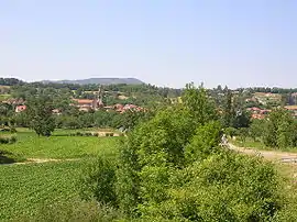 The village of Saint-Jean-de-Moirans | |
 Coat of arms | |
Location of Saint-Jean-de-Moirans 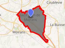
| |
 Saint-Jean-de-Moirans  Saint-Jean-de-Moirans | |
| Coordinates: 45°20′31″N 5°34′58″E | |
| Country | France |
| Region | Auvergne-Rhône-Alpes |
| Department | Isère |
| Arrondissement | Grenoble |
| Canton | Tullins |
| Intercommunality | CA Pays Voironnais |
| Government | |
| • Mayor (2014–2020) | Laurence Béthune |
| Area 1 | 6.43 km2 (2.48 sq mi) |
| Population (2017-01-01)[1] | 3,536 |
| • Density | 550/km2 (1,400/sq mi) |
| Time zone | UTC+01:00 (CET) |
| • Summer (DST) | UTC+02:00 (CEST) |
| INSEE/Postal code | 38400 /38430 |
| Elevation | 186–304 m (610–997 ft) (avg. 220 m or 720 ft) |
| 1 French Land Register data, which excludes lakes, ponds, glaciers > 1 km2 (0.386 sq mi or 247 acres) and river estuaries. | |
Population
| Year | Pop. | ±% |
|---|---|---|
| 1793 | 953 | — |
| 1806 | 1,157 | +21.4% |
| 1821 | 1,171 | +1.2% |
| 1831 | 1,107 | −5.5% |
| 1841 | 1,186 | +7.1% |
| 1851 | 1,217 | +2.6% |
| 1861 | 1,226 | +0.7% |
| 1872 | 1,102 | −10.1% |
| 1881 | 1,295 | +17.5% |
| 1891 | 1,188 | −8.3% |
| 1901 | 1,477 | +24.3% |
| 1911 | 1,324 | −10.4% |
| 1921 | 1,281 | −3.2% |
| 1931 | 1,461 | +14.1% |
| 1946 | 1,195 | −18.2% |
| 1954 | 1,550 | +29.7% |
| 1962 | 1,462 | −5.7% |
| 1968 | 1,579 | +8.0% |
| 1975 | 1,409 | −10.8% |
| 1982 | 1,896 | +34.6% |
| 1990 | 2,399 | +26.5% |
| 1999 | 2,680 | +11.7% |
| 2006 | 2,918 | +8.9% |
| 2011 | 3,152 | +8.0% |
See also
References
- "Populations légales 2017". INSEE. Retrieved 6 January 2020.
| Wikimedia Commons has media related to Saint-Jean-de-Moirans. |
| Authority control |
|---|
This article is issued from Wikipedia. The text is licensed under Creative Commons - Attribution - Sharealike. Additional terms may apply for the media files.