Saint-Jean-d'Hérans
Saint-Jean-d'Hérans is a commune in the Isère department in southeastern France.
Saint-Jean-d'Hérans | |
|---|---|
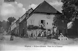 Saint-Jean-d'Hérans in 1905 | |
Location of Saint-Jean-d'Hérans 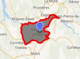
| |
 Saint-Jean-d'Hérans  Saint-Jean-d'Hérans | |
| Coordinates: 44°51′14″N 5°45′41″E | |
| Country | France |
| Region | Auvergne-Rhône-Alpes |
| Department | Isère |
| Arrondissement | Grenoble |
| Canton | Matheysine-Trièves |
| Government | |
| • Mayor (2014–2020) | Jean-Pierre Viallat |
| Area 1 | 17 km2 (7 sq mi) |
| Population (2017-01-01)[1] | 288 |
| • Density | 17/km2 (44/sq mi) |
| Time zone | UTC+01:00 (CET) |
| • Summer (DST) | UTC+02:00 (CEST) |
| INSEE/Postal code | 38403 /38710 |
| Elevation | 486–1,101 m (1,594–3,612 ft) (avg. 826 m or 2,710 ft) |
| 1 French Land Register data, which excludes lakes, ponds, glaciers > 1 km2 (0.386 sq mi or 247 acres) and river estuaries. | |
Population
| Year | Pop. | ±% |
|---|---|---|
| 1793 | 610 | — |
| 1806 | 711 | +16.6% |
| 1821 | 545 | −23.3% |
| 1831 | 760 | +39.4% |
| 1841 | 759 | −0.1% |
| 1851 | 752 | −0.9% |
| 1861 | 756 | +0.5% |
| 1872 | 691 | −8.6% |
| 1881 | 656 | −5.1% |
| 1891 | 555 | −15.4% |
| 1901 | 514 | −7.4% |
| 1911 | 501 | −2.5% |
| 1921 | 418 | −16.6% |
| 1931 | 365 | −12.7% |
| 1946 | 321 | −12.1% |
| 1954 | 508 | +58.3% |
| 1962 | 314 | −38.2% |
| 1968 | 227 | −27.7% |
| 1975 | 210 | −7.5% |
| 1982 | 218 | +3.8% |
| 1990 | 233 | +6.9% |
| 1999 | 242 | +3.9% |
| 2006 | 295 | +21.9% |
| 2011 | 299 | +1.4% |
See also
References
| Wikimedia Commons has media related to Saint-Jean-d'Hérans. |
- "Populations légales 2017". INSEE. Retrieved 6 January 2020.
| Authority control |
|---|
This article is issued from Wikipedia. The text is licensed under Creative Commons - Attribution - Sharealike. Additional terms may apply for the media files.